
പ്രമാണം:Parisattacks.png
ഈ പ്രിവ്യൂവിന്റെ വലിപ്പം: 279 × 598 പിക്സലുകൾ. മറ്റ് റെസലൂഷനുകൾ: 112 × 240 പിക്സലുകൾ | 224 × 480 പിക്സലുകൾ | 358 × 768 പിക്സലുകൾ | 477 × 1,024 പിക്സലുകൾ | 1,946 × 4,171 പിക്സലുകൾ.
പൂർണ്ണ വലിപ്പം (1,946 × 4,171 പിക്സൽ, പ്രമാണത്തിന്റെ വലിപ്പം: 12.78 എം.ബി., മൈം തരം: image/png)
| ഈ പ്രമാണം വിക്കിമീഡിയ കോമൺസിൽ നിന്നുള്ളതാണ്. പ്രമാണത്തെക്കുറിച്ചുള്ള വിവരണം താഴെ കൊടുത്തിരിക്കുന്നു.
|

|
ഈ map ചിത്രം വെക്റ്റർ ഗ്രാഫിക്സ് ഉപയോഗിച്ച് എസ്.വി.ജി. പ്രമാണമായി പുനർനിർമ്മിക്കേണ്ടതാണ്. അങ്ങനെ ചെയ്യുന്നതുകൊണ്ട് പല ഗുണങ്ങളുമുണ്ട്; കൂടുതൽ വിവരങ്ങൾക്ക് മെച്ചപ്പെടുത്തുവാനുള്ള മീഡിയകൾ കാണുക. ഈ ചിത്രത്തിന്റെ എസ്.വി.ജി. പതിപ്പ് കൈവശമുണ്ടെങ്കിൽ ദയവായി അപ്ലോഡ് ചെയ്യുക. അപ്ലോഡ് ചെയ്ത ശേഷം ഈ ഫലകം {{vector version available|പുതിയ ചിത്രത്തിന്റെ പേര്.svg}} എന്ന് മാറ്റിച്ചേർക്കുക.
|
| വിവരണം |
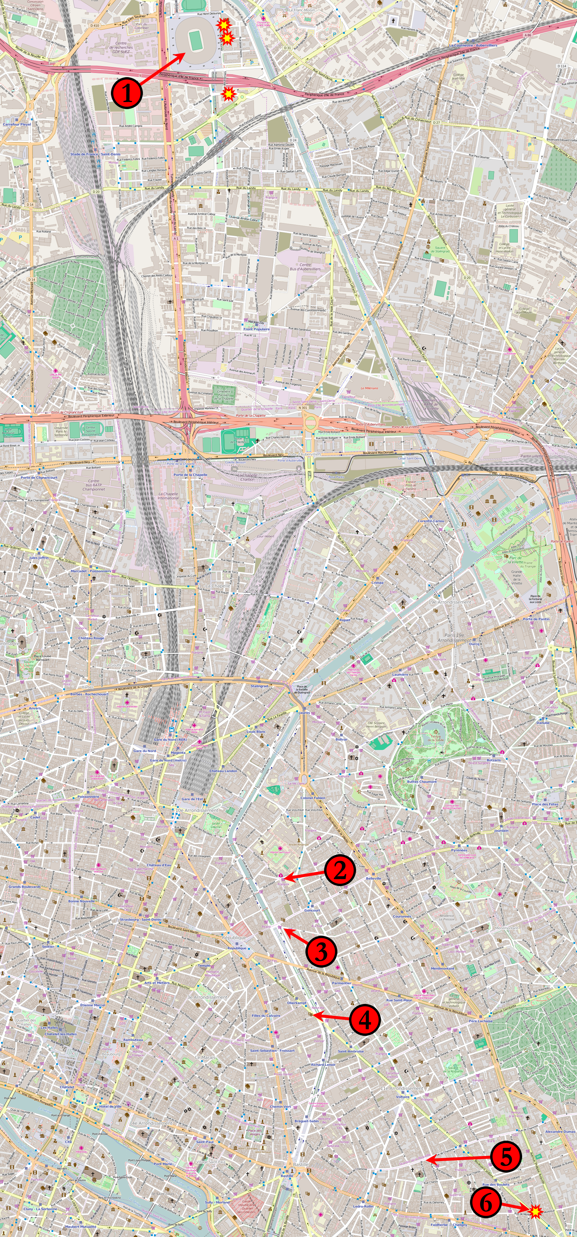
Français : Carte de novembre 2015, attaques parisiennes coordonnées.
(1) 21 h 20, 21 h 30, 21 h 53 : Stade de France à Saint-Denis. (2) 21 h 25 : Le Carillon, croisement des rues Alibert et Bichat et Le petit Cambodge, rue Alibert. (3) 21 h 32 : Café Bonne Bière, rue du Faubourg-du-Temple et Casa Nostra, rue de la Fontaine-au-Roi. (4) 21 h 40 : Le Bataclan, bar-concert, boulevard Voltaire. (5) 21 h 36 : La Belle Équipe, rue de Charonne. (6) 21 h 46 : Comptoir Voltaire, boulevard Voltaire. Étoiles : Attaques suicide à la ceinture explosive autour du Stade de France et du restaurant Comptoir Voltaire. Les kamikazes du Bataclan ne sont pas identifiés individuellement. English: Map of the November 2015 Paris attacks in relation to each other.
(1) 21:20, 21:30, 21:53 : Stade de France in Saint-Denis. (2) 21:25 : Le Carillon, junction of rue Bichat and rue Alibert and Le petit Cambodge, rue Alibert. (3) 21:32 : Café Bonne Bière, rue du Faubourg-du-Temple and Casa Nostra, rue de la Fontaine-au-Roi. (4) 21:40 : Le Bataclan theatre. (5) 21:36 : La Belle Équipe, rue de Charonne. (6) 21:46 : Comptoir Voltaire, boulevard Voltaire. Stars: Individual suicide bombings around the Stade de France and the Comptoir Voltaire restaurant. The suicide bombings at Le Bataclan are not individually distinguished. Čeština: Mapa míst teroristických útoků v Paříži:
1) Stade de France 2) křížení ulic Rue Bichat a Rue Alibert 3) Casa Nostra, Rue de la Fontaine-au-Roi 4) koncertní sál Bataclan 5) Rue de Charonne 6) Comptoir Voltaire, boulevard Voltaire. Русский: Карта мест террористических актов в Париже 13 ноября 2015 года: 1) «Стад де Франс» 2) пересечение улиц Rue Bichat и Rue Alibert 3) Casa Nostra, Rue de la Fontaine 4) концертный зал театра «Батаклан» 5) улица Rue de Charonne |
|||
| തീയതി | ||||
| സ്രോതസ്സ് | Base map from OpenStreetMap | |||
| സ്രഷ്ടാവ് | Veggies | |||
| അനുമതി (ഈ പ്രമാണത്തിന്റെ പുനരുപയോഗം) |
ഈ പ്രമാണത്തിന് അനുമതി നൽകപ്പെട്ടിരിക്കുന്നത് ക്രിയേറ്റീവ് കോമൺസ് ആട്രിബ്യൂഷൻ 2.0 ആട്രിബ്യൂഷൻ-ഷെയർ എലൈക് സാമാന്യ അനുവാദപത്ര പ്രകാരമാണ്.
|
|||
| മറ്റു പതിപ്പുകൾ |
 |
പ്രമാണ നാൾവഴി
ഏതെങ്കിലും തീയതി/സമയ കണ്ണിയിൽ ഞെക്കിയാൽ പ്രസ്തുതസമയത്ത് ഈ പ്രമാണം എങ്ങനെയായിരുന്നു എന്നു കാണാം.
| തീയതി/സമയം | ലഘുചിത്രം | അളവുകൾ | ഉപയോക്താവ് | അഭിപ്രായം | |
|---|---|---|---|---|---|
| നിലവിലുള്ളത് | 11:15, 20 നവംബർ 2015 | | 1,946 × 4,171 (12.78 എം.ബി.) | Veggies | Returning to original size. Map is unreadable in reduced version. |
| 20:11, 19 നവംബർ 2015 |  | 933 × 2,000 (3.85 എം.ബി.) | Flappiefh | Reduced the size of the picture to relieve Wikimedia servers. | |
| 18:27, 18 നവംബർ 2015 |  | 1,946 × 4,171 (14.59 എം.ബി.) | Flappiefh | Added a number next to the kamikaze attack near the Comptoir Voltaire. | |
| 04:18, 15 നവംബർ 2015 |  | 1,946 × 4,171 (12.79 എം.ബി.) | Veggies | Added the locations for the individual suicide bombings around the stadium and at the Comptoir Voltaire restaurant on Boulevard Voltaire. | |
| 13:15, 14 നവംബർ 2015 |  | 1,946 × 4,171 (12.77 എം.ബി.) | Veggies | Changed numbers to match order of attacks, added Casa Nostra location | |
| 05:17, 14 നവംബർ 2015 |  | 1,946 × 4,171 (12.78 എം.ബി.) | Veggies | {{Information |Description ={{en|1=Map of the November 2015 Paris attacks in relation to each other.}} |Source =Base map from [https://www.openstreetmap.org OpenStreetMap] |Author =Veggies |Date =2014-11-14... |
പ്രമാണത്തിന്റെ ഉപയോഗം
താഴെ കാണുന്ന താളിൽ ഈ ചിത്രം ഉപയോഗിക്കുന്നു:
പ്രമാണത്തിന്റെ ആഗോള ഉപയോഗം
താഴെ കൊടുത്തിരിക്കുന്ന മറ്റ് വിക്കികൾ ഈ പ്രമാണം ഉപയോഗിക്കുന്നു:
- ar.wikipedia.org സംരംഭത്തിലെ ഉപയോഗം
- arz.wikipedia.org സംരംഭത്തിലെ ഉപയോഗം
- as.wikipedia.org സംരംഭത്തിലെ ഉപയോഗം
- az.wikipedia.org സംരംഭത്തിലെ ഉപയോഗം
- bat-smg.wikipedia.org സംരംഭത്തിലെ ഉപയോഗം
- bg.wikipedia.org സംരംഭത്തിലെ ഉപയോഗം
- bn.wikipedia.org സംരംഭത്തിലെ ഉപയോഗം
- br.wikipedia.org സംരംഭത്തിലെ ഉപയോഗം
- bs.wikipedia.org സംരംഭത്തിലെ ഉപയോഗം
- ca.wikipedia.org സംരംഭത്തിലെ ഉപയോഗം
- ca.wikinews.org സംരംഭത്തിലെ ഉപയോഗം
- cs.wikipedia.org സംരംഭത്തിലെ ഉപയോഗം
- cs.wikinews.org സംരംഭത്തിലെ ഉപയോഗം
- da.wikipedia.org സംരംഭത്തിലെ ഉപയോഗം
- diq.wikipedia.org സംരംഭത്തിലെ ഉപയോഗം
- el.wikipedia.org സംരംഭത്തിലെ ഉപയോഗം
- en.wikipedia.org സംരംഭത്തിലെ ഉപയോഗം
- eo.wikipedia.org സംരംഭത്തിലെ ഉപയോഗം
- eo.wikinews.org സംരംഭത്തിലെ ഉപയോഗം
- es.wikipedia.org സംരംഭത്തിലെ ഉപയോഗം
- et.wikipedia.org സംരംഭത്തിലെ ഉപയോഗം
- eu.wikipedia.org സംരംഭത്തിലെ ഉപയോഗം
- fa.wikipedia.org സംരംഭത്തിലെ ഉപയോഗം
- fi.wikipedia.org സംരംഭത്തിലെ ഉപയോഗം
- fo.wikipedia.org സംരംഭത്തിലെ ഉപയോഗം
- fr.wikipedia.org സംരംഭത്തിലെ ഉപയോഗം
- fr.wikinews.org സംരംഭത്തിലെ ഉപയോഗം
- ga.wikipedia.org സംരംഭത്തിലെ ഉപയോഗം
- glk.wikipedia.org സംരംഭത്തിലെ ഉപയോഗം
- gl.wikipedia.org സംരംഭത്തിലെ ഉപയോഗം
- he.wikipedia.org സംരംഭത്തിലെ ഉപയോഗം
- hi.wikipedia.org സംരംഭത്തിലെ ഉപയോഗം
- hr.wikipedia.org സംരംഭത്തിലെ ഉപയോഗം
- hu.wikipedia.org സംരംഭത്തിലെ ഉപയോഗം
- hy.wikipedia.org സംരംഭത്തിലെ ഉപയോഗം
- id.wikipedia.org സംരംഭത്തിലെ ഉപയോഗം
- io.wikipedia.org സംരംഭത്തിലെ ഉപയോഗം
- is.wikipedia.org സംരംഭത്തിലെ ഉപയോഗം
- it.wikinews.org സംരംഭത്തിലെ ഉപയോഗം
- ja.wikipedia.org സംരംഭത്തിലെ ഉപയോഗം
ഈ പ്രമാണത്തിന്റെ കൂടുതൽ ആഗോള ഉപയോഗം കാണുക.