
പ്രമാണം:Ceratopsian map.png

ഈ പ്രിവ്യൂവിന്റെ വലിപ്പം: 800 × 352 പിക്സലുകൾ. മറ്റ് റെസലൂഷനുകൾ: 320 × 141 പിക്സലുകൾ | 640 × 282 പിക്സലുകൾ | 1,427 × 628 പിക്സലുകൾ.
പൂർണ്ണ വലിപ്പം (1,427 × 628 പിക്സൽ, പ്രമാണത്തിന്റെ വലിപ്പം: 72 കെ.ബി., മൈം തരം: image/png)
| ഈ പ്രമാണം വിക്കിമീഡിയ കോമൺസിൽ നിന്നുള്ളതാണ്. പ്രമാണത്തെക്കുറിച്ചുള്ള വിവരണം താഴെ കൊടുത്തിരിക്കുന്നു.
|
File:Ceratopsian map.png requires updating
Hi Ceratopsian map.png,
Thank you for your contributions to Commons. I noticed File:Ceratopsian map.png is out of date. Does not include localitiy of Ferrisaurus Could you update it? Thanks again. Extrapolaris (സംവാദം) 01:17, 11 November 2019 (UTC) Vahe Demirjian
- @Extrapolaris: Done. Thanks for informing me, next time you could leave message on my talk page directly (in traditional Chinese) so I can see it sooner. -- Tiouraren (സംവാദം) 10:21, 31 January 2020 (UTC)
ചുരുക്കം
| വിവരണം |
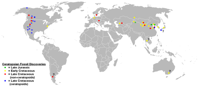
English: Map of ceratopsian fossil localities as of September 2006. I used the blank political map of the world commonly used on Wikipedia ((BlankMap-World.png).
Keep in mind that the land masses would not have been in the same places they are today in the Jurassic and Cretaceous periods. |
| തീയതി | 17 മാർച്ച് 2009 (യഥാർത്ഥ അപ്ലോഡ് തീയതി) |
| സ്രോതസ്സ് | en.wikipedia പദ്ധതിയിൽ നിന്നും കോമൺസിലേയ്ക്ക് ഉപയോക്താവ് FunkMonk, CommonsHelper എന്ന ഉപകരണം ഉപയോഗിച്ച് മാറ്റിയത്. |
| സ്രഷ്ടാവ് | ഇംഗ്ലീഷ് വിക്കിപീഡിയ പദ്ധതിയിലെ Sheep81 |
അനുമതി
| ഈ സൃഷ്ടി അതിന്റെ സ്രഷ്ടാവായ ഇംഗ്ലീഷ് വിക്കിപീഡിയ പദ്ധതിയിലെ Sheep81, സ്വയം പൊതുസഞ്ചയത്തിൽ പ്രസിദ്ധീകരിച്ചിരിക്കുന്നു. ഇത് ആഗോള വ്യാപകമായി ബാധകമാണ്. ചില രാജ്യങ്ങളിൽ ഇത് നിയമപ്രകാരം സാദ്ധ്യമല്ലെന്ന് വന്നേക്കാം; അങ്ങനെയെങ്കിൽ: ഈ സൃഷ്ടി, നിയമപ്രകാരം നിബന്ധനകൾ ഉണ്ടെങ്കിൽ അവയൊഴിച്ച്, യാതൊരു നിബന്ധനകളും ഇല്ലാതെ ഏതൊരാൾക്കും ഏതൊരു ഉപയോഗത്തിനും, ഉപയോഗപ്പെടുത്തുവാൻ Sheep81 അനുവദിച്ചിരിക്കുന്നു. |
യഥാർത്ഥ അപ്ലോഡ് രേഖ
ഈ ചിത്രം ആദ്യം അപ്ലോഡ് ചെയ്തത് ഇവിടെ കാണാം. താഴെയുള്ള എല്ലാ ഉപയോക്തൃനാമവും ഉള്ളത് en.wikipedia സംരംഭത്തിൽ ആണ്.
- 2009-03-17 18:48 Dinoguy2 1427×628× (47473 bytes) ''Turanoceratops'' as a ceratopsid, not non-ceratopsid (red dot -> blue dot).
- 2006-09-20 06:18 Sheep81 1427×628× (45407 bytes)
- 2006-09-20 04:44 Sheep81 1427×628× (45348 bytes) Map of ceratopsian fossil localities as of September 2006. I used the blank political map of the world commonly used on Wikipedia ((BlankMap-World.png). Keep in mind that the land masses would not have been in the same places they are today in the Jurass
പ്രമാണ നാൾവഴി
ഏതെങ്കിലും തീയതി/സമയ കണ്ണിയിൽ ഞെക്കിയാൽ പ്രസ്തുതസമയത്ത് ഈ പ്രമാണം എങ്ങനെയായിരുന്നു എന്നു കാണാം.
| തീയതി/സമയം | ലഘുചിത്രം | അളവുകൾ | ഉപയോക്താവ് | അഭിപ്രായം | |
|---|---|---|---|---|---|
| നിലവിലുള്ളത് | 10:11, 31 ജനുവരി 2020 | | 1,427 × 628 (72 കെ.ബി.) | Tiouraren | Added the locality of Ferrisaurus |
| 06:07, 31 ജൂലൈ 2019 |  | 1,427 × 628 (72 കെ.ബി.) | Tiouraren | fixing political border | |
| 14:51, 17 ജൂലൈ 2019 |  | 1,427 × 628 (71 കെ.ബി.) | Tiouraren | Records from Sweden (Lindgren et al., 2007) and Japan (Manabe et al., 2016) added | |
| 07:38, 14 ജൂലൈ 2019 |  | 1,427 × 628 (70 കെ.ബി.) | Tiouraren | Add locality of 50+ basal ceratopsian fossils and Crittendenceratops. | |
| 06:18, 14 ജൂലൈ 2019 |  | 1,427 × 628 (70 കെ.ബി.) | Tiouraren | Turanocertops update | |
| 06:53, 4 ജൂലൈ 2018 |  | 1,427 × 628 (61 കെ.ബി.) | Tiouraren | Add ''Sinoceratops'', ''Koreaceratops'', ''Yehuecauhceratops'', and ''Machairoceratops'' | |
| 21:46, 26 മാർച്ച് 2009 |  | 1,427 × 628 (46 കെ.ബി.) | File Upload Bot (Magnus Manske) | {{BotMoveToCommons|en.wikipedia|year={{subst:CURRENTYEAR}}|month={{subst:CURRENTMONTHNAME}}|day={{subst:CURRENTDAY}}}} {{Information |Description={{en|Map of ceratopsian fossil localities as of September 2006. I used the blank political map of the world |
പ്രമാണത്തിന്റെ ഉപയോഗം
താഴെ കാണുന്ന താളിൽ ഈ ചിത്രം ഉപയോഗിക്കുന്നു:
പ്രമാണത്തിന്റെ ആഗോള ഉപയോഗം
താഴെ കൊടുത്തിരിക്കുന്ന മറ്റ് വിക്കികൾ ഈ പ്രമാണം ഉപയോഗിക്കുന്നു:
- en.wikipedia.org സംരംഭത്തിലെ ഉപയോഗം
- es.wikipedia.org സംരംഭത്തിലെ ഉപയോഗം
- hr.wikipedia.org സംരംഭത്തിലെ ഉപയോഗം
- hu.wikipedia.org സംരംഭത്തിലെ ഉപയോഗം
- ko.wikipedia.org സംരംഭത്തിലെ ഉപയോഗം
- pl.wikipedia.org സംരംഭത്തിലെ ഉപയോഗം
- sh.wikipedia.org സംരംഭത്തിലെ ഉപയോഗം
- tr.wikipedia.org സംരംഭത്തിലെ ഉപയോഗം
- uk.wikipedia.org സംരംഭത്തിലെ ഉപയോഗം
- zh.wikipedia.org സംരംഭത്തിലെ ഉപയോഗം