
പ്രമാണം:Europe location SCO2.png

ഈ പ്രിവ്യൂവിന്റെ വലിപ്പം: 800 × 599 പിക്സലുകൾ. മറ്റ് റെസലൂഷനുകൾ: 320 × 240 പിക്സലുകൾ | 640 × 479 പിക്സലുകൾ | 1,024 × 767 പിക്സലുകൾ | 1,280 × 959 പിക്സലുകൾ | 1,594 × 1,194 പിക്സലുകൾ.
പൂർണ്ണ വലിപ്പം (1,594 × 1,194 പിക്സൽ, പ്രമാണത്തിന്റെ വലിപ്പം: 558 കെ.ബി., മൈം തരം: image/png)
| ഈ പ്രമാണം വിക്കിമീഡിയ കോമൺസിൽ നിന്നുള്ളതാണ്. പ്രമാണത്തെക്കുറിച്ചുള്ള വിവരണം താഴെ കൊടുത്തിരിക്കുന്നു.
|
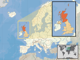
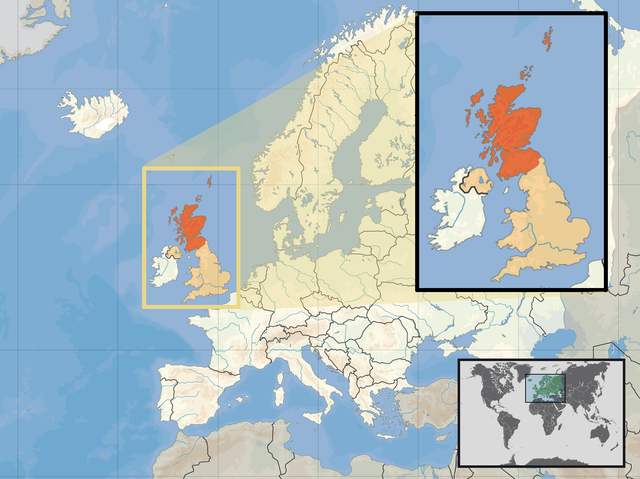
| വിവരണം | Location of Scotland in the UK and Europe, on terrain map showing surface and underwater contour areas. | |||
| തീയതി | ||||
| സ്രോതസ്സ് | Derived from Wikimedia Commons image of original work forming part of the "Europe location" map series created by David Liuzzo: derived from Image:Europe_location_SCO.png. | |||
| സ്രഷ്ടാവ് | uploaded by User:Kmusser (excerpt from User:David_Liuzzo) | |||
| അനുമതി (ഈ പ്രമാണത്തിന്റെ പുനരുപയോഗം) |
|
|||
| മറ്റു പതിപ്പുകൾ |
|


പ്രമാണ നാൾവഴി
ഏതെങ്കിലും തീയതി/സമയ കണ്ണിയിൽ ഞെക്കിയാൽ പ്രസ്തുതസമയത്ത് ഈ പ്രമാണം എങ്ങനെയായിരുന്നു എന്നു കാണാം.
| തീയതി/സമയം | ലഘുചിത്രം | അളവുകൾ | ഉപയോക്താവ് | അഭിപ്രായം | |
|---|---|---|---|---|---|
| നിലവിലുള്ളത് | 12:39, 10 ഏപ്രിൽ 2017 | | 1,594 × 1,194 (558 കെ.ബി.) | Von Sprat | Reverted to version as of 12:25, 27 May 2010 (UTC) |
| 12:39, 10 ഏപ്രിൽ 2017 |  | 1,600 × 1,200 (788 കെ.ബി.) | Von Sprat | greece/turkey border | |
| 12:25, 27 മേയ് 2010 |  | 1,594 × 1,194 (558 കെ.ബി.) | Ras67 | cropped | |
| 17:31, 29 സെപ്റ്റംബർ 2008 |  | 1,600 × 1,200 (767 കെ.ബി.) | Kmusser | re-cropped inset to include Shetlands | |
| 17:22, 29 സെപ്റ്റംബർ 2008 |  | 1,600 × 1,200 (807 കെ.ബി.) | Kmusser | {{Information |Description= Location of Scotland in the UK and Europe, on terrain map showing surface and underwater contour areas. |Source=Derived from Wikimedia Commons image of original work forming part of the "Europe location" map series |
പ്രമാണത്തിന്റെ ഉപയോഗം
താഴെ കാണുന്ന താളിൽ ഈ ചിത്രം ഉപയോഗിക്കുന്നു:
പ്രമാണത്തിന്റെ ആഗോള ഉപയോഗം
താഴെ കൊടുത്തിരിക്കുന്ന മറ്റ് വിക്കികൾ ഈ പ്രമാണം ഉപയോഗിക്കുന്നു:
- als.wikipedia.org സംരംഭത്തിലെ ഉപയോഗം
- an.wikipedia.org സംരംഭത്തിലെ ഉപയോഗം
- az.wiktionary.org സംരംഭത്തിലെ ഉപയോഗം
- ca.wikipedia.org സംരംഭത്തിലെ ഉപയോഗം
- da.wikipedia.org സംരംഭത്തിലെ ഉപയോഗം
- en.wikipedia.org സംരംഭത്തിലെ ഉപയോഗം
- es.wikipedia.org സംരംഭത്തിലെ ഉപയോഗം
- eu.wiktionary.org സംരംഭത്തിലെ ഉപയോഗം
- ext.wikipedia.org സംരംഭത്തിലെ ഉപയോഗം
- fiu-vro.wikipedia.org സംരംഭത്തിലെ ഉപയോഗം
- fr.wikinews.org സംരംഭത്തിലെ ഉപയോഗം
- gag.wikipedia.org സംരംഭത്തിലെ ഉപയോഗം
- gl.wikipedia.org സംരംഭത്തിലെ ഉപയോഗം
- hr.wikipedia.org സംരംഭത്തിലെ ഉപയോഗം
- hr.wikiquote.org സംരംഭത്തിലെ ഉപയോഗം
- kn.wikipedia.org സംരംഭത്തിലെ ഉപയോഗം
- krc.wikipedia.org സംരംഭത്തിലെ ഉപയോഗം
- mnw.wikipedia.org സംരംഭത്തിലെ ഉപയോഗം
- mr.wikipedia.org സംരംഭത്തിലെ ഉപയോഗം
- my.wikipedia.org സംരംഭത്തിലെ ഉപയോഗം
- nov.wikipedia.org സംരംഭത്തിലെ ഉപയോഗം
- no.wikipedia.org സംരംഭത്തിലെ ഉപയോഗം
- pl.wikipedia.org സംരംഭത്തിലെ ഉപയോഗം
- pl.wikivoyage.org സംരംഭത്തിലെ ഉപയോഗം
- pl.wiktionary.org സംരംഭത്തിലെ ഉപയോഗം
- su.wikipedia.org സംരംഭത്തിലെ ഉപയോഗം
- sv.wikivoyage.org സംരംഭത്തിലെ ഉപയോഗം
- te.wikipedia.org സംരംഭത്തിലെ ഉപയോഗം
- tr.wikipedia.org സംരംഭത്തിലെ ഉപയോഗം
- ug.wikipedia.org സംരംഭത്തിലെ ഉപയോഗം
- vls.wikipedia.org സംരംഭത്തിലെ ഉപയോഗം
- yo.wikipedia.org സംരംഭത്തിലെ ഉപയോഗം