
"സുപ്പീരിയർ തടാകം" എന്ന താളിന്റെ പതിപ്പുകൾ തമ്മിലുള്ള വ്യത്യാസം
Content deleted Content added
'ലോകത്തിലെ ഏറ്റവും വലിയ രണ്ടാമത്തെ തടാകമാണ് സ...' താൾ സൃഷ്ടിച്ചിരിക്കുന്നു |
Fotokannan (സംവാദം | സംഭാവനകൾ) No edit summary |
||
| വരി 1: | വരി 1: | ||
{{prettyurl|Lake Superior}} |
|||
{{Infobox lake |
|||
|lake_name = Lake Superior |
|||
|image_lake = Lake Superior NASA.jpg |
|||
|caption_lake = Landsat image |
|||
|location = [[North America]] |
|||
|group = [[Great Lakes]] |
|||
|image_bathymetry = Lake-Superior.svg |
|||
|caption_bathymetry = Lake Superior and the other [[Great Lakes]] |
|||
|coords = {{Coord|47.7|N|87.5|W|name=Lake Superior|type:waterbody_scale:5000000|display=inline,title}} |
|||
|type = [[Glacial]] |
|||
|inflow = [[Nipigon River|Nipigon]], [[Saint Louis River|St. Louis]], [[Pigeon River (Minnesota-Ontario)|Pigeon]], [[Pic River|Pic]], [[White River (Ontario)|White]], [[Michipicoten River|Michipicoten]], [[Kaministiquia River]]s |
|||
|outflow = [[St. Marys River (Michigan-Ontario)|St. Marys River]] |
|||
|catchment = 49,300 sq mi (127,700 km<sup>2</sup>)<ref name="EPAphysical"/> |
|||
|basin_countries = United States<br />Canada |
|||
|length = {{convert|350|<!--statute-->smi|km|abbr=on}}<ref name=EPAfact/> |
|||
|width = {{convert|160|<!--statute-->smi|km|abbr=on}}<ref name=EPAfact/> |
|||
|area = 31,700 sq mi (82,100 km<sup>2</sup>)<ref name="EPAphysical"/> |
|||
|depth = {{convert|483|ft|m|abbr=on}}<ref name="EPAphysical"/> |
|||
|max-depth = {{convert|1332|ft|m|abbr=on}}<ref name="EPAphysical"/><ref name=nyt/> |
|||
|volume = {{convert|2900|cumi|km3|abbr=on}}<ref name="EPAphysical"/> |
|||
|residence_time = 191 years |
|||
|shore = {{convert|2726|<!--statute mile-->smi|km|abbr=on}}<ref name="EPAphysical"/> |
|||
|elevation = {{convert|601|ft|m|0|abbr=on}} (2012 average)<ref>[http://w3.lre.usace.army.mil/hh/GreatLakesWaterLevels/GLWL-CurrentMonth-Feet.pdf ''Great Lakes Water Levels], published by the US Army Corps of Engineers. The link also has daily elevations for the current month.</ref> |
|||
|islands = [[Isle Royale]], [[Apostle Islands]], [[Michipicoten Island]], [[Slate Islands (Ontario)|Slate Islands]] |
|||
|islands_category = Islands of the Great Lakes |
|||
|cities = [[Thunder Bay]], [[Ontario]]<br /> [[Duluth, Minnesota]]<br /> [[Sault Ste. Marie, Ontario]]<br /> [[Marquette, Michigan]]<br /> [[Superior, Wisconsin]]<br /> [[Sault Ste. Marie, Michigan]] |
|||
|frozen = |
|||
}} |
|||
ലോകത്തിലെ ഏറ്റവും വലിയ രണ്ടാമത്തെ തടാകമാണ് സുപ്പീരിയർ [[തടാകം]].[[കാനഡ]]യിലാണ് ഇത് സ്ഥിതിചെയ്യുന്നത്. |
ലോകത്തിലെ ഏറ്റവും വലിയ രണ്ടാമത്തെ തടാകമാണ് സുപ്പീരിയർ [[തടാകം]].[[കാനഡ]]യിലാണ് ഇത് സ്ഥിതിചെയ്യുന്നത്. |
||
===ചിത്ര ജാലകം=== |
|||
<gallery> |
|||
Image:Lakesuperiorscenic.jpg|Lake Superior shoreline from Madeline Island in the Apostles |
|||
Image:Sunriseonlakesuperior.jpg|Sunrise on Lake Superior from Washburn, Wisconsin |
|||
Image:Lake_Superior_Coast.jpg|Lake Superior coast from Copper Harbor, Michigan |
|||
Image:Lake_superior_north_shore_sunset.jpg| Sunset from northern shore of Lake Superior |
|||
</gallery> |
|||
==അവലംബം== |
|||
<references/> |
|||
==അധിക വായനയ്ക്ക്== |
|||
* [http://books.google.com/books?id=6c0QAAAAIAAJ&dq=Bela+Hubbard&printsec=frontcover&source=bl&ots=i0NAnpAXP5&sig=EVHURUWrD98XjeTC-mw4e8hz5xY&hl=en&ei=ySiXSZjLGtCCtweV182qCw&sa=X&oi=book_result&resnum=3&ct=result Burt, Williams A., and Hubbard, Bela ''Reports on the Mineral Region of Lake Superior'' (Buffalo: L. Danforth, 1846), 113 pages]. |
|||
* Grady, Wayne. ''The Great Lakes: The Natural History of a Changing Region.''Greystone Books, D&M Publishers INC, 2007 |
|||
* Hyde, Charles K., and Ann and John Mahan. ''The Northern Lights: Lighthouses of the Upper Great Lakes.'' Detroit: Wayne State University Press, 1995. ISBN 0-8143-2554-8 ISBN 9780814325544. |
|||
* Oleszewski, Wes, ''Great Lakes Lighthouses, American and Canadian: A Comprehensive Directory/Guide to Great Lakes Lighthouses'', (Gwinn, Michigan: Avery Color Studios, Inc., 1998) ISBN 0-932212-98-0. |
|||
* Penrod, John, ''Lighthouses of Michigan'', (Berrien Center, Michigan: Penrod/Hiawatha, 1998) ISBN 978-0-942618-78-5 ISBN 9781893624238 |
|||
* Penrose, Laurie and Bill, A'' Traveler’s Guide to 116 Michigan Lighthouses'' (Petoskey, Michigan: Friede Publications, 1999). ISBN 0-923756-03-5 ISBN 9780923756031 |
|||
* Sims, P.K. and L.M.H. Carter, eds. ''Archean and Proterozoic Geology of the Lake Superior Region, U.S.A., 1993'' [U.S. Geological Survey Professional Paper 1556]. Washington, D.C.: U.S. Department of the Interior, U.S. Geological Survey, 1996. |
|||
* Splake, T. Kilgore. ''Superior Land Lights''. Battle Creek, MI: Angst Productions, 1984 |
|||
* Stonehouse, Frederick. ''Marquette Shipwrecks''. Marquette, MI: Harboridge Press, 1974 |
|||
* Wagner, John L., ''Michigan Lighthouses: An Aerial Photographic Perspective'', (East Lansing, Michigan: John L. Wagner, 1998) ISBN 1-880311-01-1 ISBN 9781880311011 |
|||
* Wright, Larry and Wright, Patricia, ''Great Lakes Lighthouses Encyclopedia'' Hardback (Erin: Boston Mills Press, 2006) ISBN 1-55046-399-3 |
|||
* U.S. Army Corps of Engineers. "[http://www.edisonsault.com/CustServ/USACOE%20LS%20WATER%208%2007.pdf Record Low Water Levels Expected on Lake Superior]." August 2007 |
|||
* Great Lakes Environmental Research Laboratory. "[http://www.glerl.noaa.gov/res/Programs/glscf/hydrology.html Great Lakes Sensitivity to Climatic Forcing: Hydrological Models]." NOAA, 2006 |
|||
;Shipwrecks |
|||
* "America"; Houghton, Michigan; Houghton Mining Gazette; Vol. 29; June 8, 1928 |
|||
* Stonehouse, Frederick; Isle Royale Shipwrecks; Marquette, Michigan; Arery Color Studios; 1977 |
|||
* "Cumberland" & "Wreck of Sidewheel Steamer Cumberland"; Detroit, Michigan; Detroit Free Press; January 29, 1974 |
|||
* "S.S.George M. Cox Wrecked"; Houghton, Michigan; Houghton Mining Gazette; May 28, 1933 |
|||
* Holdon, Thom "Reef of the Three C's"; Duluth, Minnesota; Lake Superior Marine Museum; Vol. 2, #4; July/August 1977 |
|||
* Holdon, Thom; "Above and Below: Steamer America"; Duluth, Minnesota; Lake Superior Marine Museum; Vol. 3, #3 & #4; May/June & July/August 1978 |
|||
==പുറം കണ്ണികൾ== |
|||
{{Commons category|Lake Superior}} |
|||
* [http://www.charts.noaa.gov/OnLineViewer/14961.shtml Lake Superior NOAA nautical chart #14961 online] |
|||
* [http://www.ijc.org/conseil_board/superior_lake/en/superior_home_accueil.htm International Lake Superior Board of Control] |
|||
* [http://www.epa.gov/glnpo/atlas/index.html EPA's Great Lakes Atlas] |
|||
* [http://www.epa.gov/glnpo/atlas/gl-fact1.html EPA's Great Lakes Atlas Factsheet #1] |
|||
* [http://www.coastwatch.msu.edu/ Great Lakes Coast Watch] |
|||
* [http://www.pc.gc.ca/progs/amnc-nmca/plan/gla2_E.asp Parks Canada Lake Superior] |
|||
* [http://seagrant.umn.edu/superior/ Minnesota Sea Grant - Lake Superior Page] |
|||
* [http://www.nrri.umn.edu/lsgis/bathy.htm Lake Superior Bathymetry] |
|||
01:24, 22 ജൂലൈ 2013-നു നിലവിലുണ്ടായിരുന്ന രൂപം
| സുപ്പീരിയർ തടാകം | |
|---|---|
 Lake Superior and the other Great Lakes | |
| സ്ഥാനം | North America |
| ഗ്രൂപ്പ് | Great Lakes |
| നിർദ്ദേശാങ്കങ്ങൾ | 47°42′N 87°30′W / 47.7°N 87.5°W |
| Type | Glacial |
| പ്രാഥമിക അന്തർപ്രവാഹം | Nipigon, St. Louis, Pigeon, Pic, White, Michipicoten, Kaministiquia Rivers |
| Primary outflows | St. Marys River |
| Catchment area | 49,300 sq mi (127,700 km2)[1] |
| Basin countries | United States Canada |
| പരമാവധി നീളം | 350 mi (560 km)[2] |
| പരമാവധി വീതി | 160 mi (260 km)[2] |
| ഉപരിതല വിസ്തീർണ്ണം | 31,700 sq mi (82,100 km2)[1] |
| ശരാശരി ആഴം | 483 ft (147 m)[1] |
| പരമാവധി ആഴം | 1,332 ft (406 m)[1][3] |
| Water volume | 2,900 cu mi (12,000 km3)[1] |
| Residence time | 191 years |
| തീരത്തിന്റെ നീളം1 | 2,726 mi (4,387 km)[1] |
| ഉപരിതല ഉയരം | 601 ft (183 m) (2012 average)[4] |
| ദ്വീപുകൾ | Isle Royale, Apostle Islands, Michipicoten Island, Slate Islands |
| അധിവാസ സ്ഥലങ്ങൾ | Thunder Bay, Ontario Duluth, Minnesota Sault Ste. Marie, Ontario Marquette, Michigan Superior, Wisconsin Sault Ste. Marie, Michigan |
| 1 Shore length is not a well-defined measure. | |
ലോകത്തിലെ ഏറ്റവും വലിയ രണ്ടാമത്തെ തടാകമാണ് സുപ്പീരിയർ തടാകം.കാനഡയിലാണ് ഇത് സ്ഥിതിചെയ്യുന്നത്.
ചിത്ര ജാലകം
-
 Lake Superior shoreline from Madeline Island in the Apostles
 -
 Sunrise on Lake Superior from Washburn, Wisconsin
 -
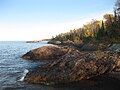 Lake Superior coast from Copper Harbor, Michigan
 -
 Sunset from northern shore of Lake Superior


അവലംബം
- ↑ 1.0 1.1 1.2 1.3 1.4 1.5 ഉദ്ധരിച്ചതിൽ പിഴവ്: അസാധുവായ
<ref>ടാഗ്;EPAphysicalഎന്ന പേരിലെ അവലംബങ്ങൾക്ക് എഴുത്തൊന്നും നൽകിയിട്ടില്ല. - ↑ 2.0 2.1 ഉദ്ധരിച്ചതിൽ പിഴവ്: അസാധുവായ
<ref>ടാഗ്;EPAfactഎന്ന പേരിലെ അവലംബങ്ങൾക്ക് എഴുത്തൊന്നും നൽകിയിട്ടില്ല. - ↑ ഉദ്ധരിച്ചതിൽ പിഴവ്: അസാധുവായ
<ref>ടാഗ്;nytഎന്ന പേരിലെ അവലംബങ്ങൾക്ക് എഴുത്തൊന്നും നൽകിയിട്ടില്ല. - ↑ Great Lakes Water Levels, published by the US Army Corps of Engineers. The link also has daily elevations for the current month.
അധിക വായനയ്ക്ക്
- Burt, Williams A., and Hubbard, Bela Reports on the Mineral Region of Lake Superior (Buffalo: L. Danforth, 1846), 113 pages.
- Grady, Wayne. The Great Lakes: The Natural History of a Changing Region.Greystone Books, D&M Publishers INC, 2007
- Hyde, Charles K., and Ann and John Mahan. The Northern Lights: Lighthouses of the Upper Great Lakes. Detroit: Wayne State University Press, 1995. ISBN 0-8143-2554-8 ISBN 9780814325544.
- Oleszewski, Wes, Great Lakes Lighthouses, American and Canadian: A Comprehensive Directory/Guide to Great Lakes Lighthouses, (Gwinn, Michigan: Avery Color Studios, Inc., 1998) ISBN 0-932212-98-0.
- Penrod, John, Lighthouses of Michigan, (Berrien Center, Michigan: Penrod/Hiawatha, 1998) ISBN 978-0-942618-78-5 ISBN 9781893624238
- Penrose, Laurie and Bill, A Traveler’s Guide to 116 Michigan Lighthouses (Petoskey, Michigan: Friede Publications, 1999). ISBN 0-923756-03-5 ISBN 9780923756031
- Sims, P.K. and L.M.H. Carter, eds. Archean and Proterozoic Geology of the Lake Superior Region, U.S.A., 1993 [U.S. Geological Survey Professional Paper 1556]. Washington, D.C.: U.S. Department of the Interior, U.S. Geological Survey, 1996.
- Splake, T. Kilgore. Superior Land Lights. Battle Creek, MI: Angst Productions, 1984
- Stonehouse, Frederick. Marquette Shipwrecks. Marquette, MI: Harboridge Press, 1974
- Wagner, John L., Michigan Lighthouses: An Aerial Photographic Perspective, (East Lansing, Michigan: John L. Wagner, 1998) ISBN 1-880311-01-1 ISBN 9781880311011
- Wright, Larry and Wright, Patricia, Great Lakes Lighthouses Encyclopedia Hardback (Erin: Boston Mills Press, 2006) ISBN 1-55046-399-3
- U.S. Army Corps of Engineers. "Record Low Water Levels Expected on Lake Superior." August 2007
- Great Lakes Environmental Research Laboratory. "Great Lakes Sensitivity to Climatic Forcing: Hydrological Models." NOAA, 2006
- Shipwrecks
- "America"; Houghton, Michigan; Houghton Mining Gazette; Vol. 29; June 8, 1928
- Stonehouse, Frederick; Isle Royale Shipwrecks; Marquette, Michigan; Arery Color Studios; 1977
- "Cumberland" & "Wreck of Sidewheel Steamer Cumberland"; Detroit, Michigan; Detroit Free Press; January 29, 1974
- "S.S.George M. Cox Wrecked"; Houghton, Michigan; Houghton Mining Gazette; May 28, 1933
- Holdon, Thom "Reef of the Three C's"; Duluth, Minnesota; Lake Superior Marine Museum; Vol. 2, #4; July/August 1977
- Holdon, Thom; "Above and Below: Steamer America"; Duluth, Minnesota; Lake Superior Marine Museum; Vol. 3, #3 & #4; May/June & July/August 1978
പുറം കണ്ണികൾ
Lake Superior എന്ന വിഷയവുമായി ബന്ധപ്പെട്ട ചിത്രങ്ങൾ വിക്കിമീഡിയ കോമൺസിലുണ്ട്.