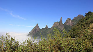
സെറ ഡോസ് ഒർഗാവോസ് ദേശീയോദ്യാനം
| സെറ ഡോസ് ഒർഗാവോസ് ദേശീയോദ്യാനം | |
|---|---|
| Parque Nacional da Serra dos Órgãos | |
ഐ.യു.സി.എൻ. ഗണം II (ദേശീയോദ്യാനം) | |
 Rock formations and the God's Finger peak in the background | |
| Nearest city | Teresópolis |
| Coordinates | 22°27′40″S 42°59′49″W / 22.461°S 42.997°W |
| Area | 10,527 ha (40.64 sq mi) |
| Designation | National park (Brazil) |
| Created | 1939 |
| Administrator | Chico Mendes Institute for Biodiversity Conservation |
സെറ ഡോസ് ഒർഗാവോസ് ദേശീയോദ്യാനം (പോർച്ചുഗീസ്: Parque Nacional da Serra dos Órgãos: "Organs Range") ബ്രസീലിലെ റിയോ ഡി ജെനീറോ സംസ്ഥാനത്തു സ്ഥിതിചെയ്യുന്ന ഒരു ദേശീയോദ്യാനമാണ്. സെറാ ഡോസ് ഓർഗാവോസ് മലനിരകളെയും അതിലെ ജലസ്രോതസ്സുകളെയും ഈ ദേശീയോദ്യാനം പരിരക്ഷിക്കുന്നു. ബ്രസീലിൽ രൂപീകരിക്കപ്പെട്ട മൂന്നാമത്തെ ദേശീയോദ്യാനമായിരുന്നു ഇത്.
ചിത്രശാല[തിരുത്തുക]
-
Peaks (from left to right): Escalavrado, Dedo de Nossa Senhora, Dedo de Deus, Cabeça de Peixe and Santo Antônio.
-
God's Finger
-
Devil's Needle
-
View of the park in Teresópolis, part of the Serra do Mar mountain range
-
Sunrise
-
Swimming pool with mineral water
-
Trail at the park, Petrópolis
-
Forest trail in Guapimirim
-
Suspended trail into the woods
-
Lake Comary in Teresópolis, with the Escalavrado and the God's Finger (far right) peaks in the background


