സാൻ പാബ്ലോ
സാൻ പാബ്ലോ നഗരം | ||
|---|---|---|
 Welcome sign over San Pablo Avenue | ||
| ||
| Motto(s): " City of New Directions " | ||
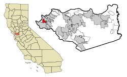
 Location in Contra Costa County and the state of California | ||
| Coordinates: 37°57′44″N 122°20′44″W / 37.96222°N 122.34556°W | ||
| Country | ||
| State | ||
| County | Contra Costa | |
| Incorporated | April 27, 1948[1] | |
| • Mayor | Cecilia Valdez [2] | |
| • County Board | District 1: John Gioia | |
| • State Senator | Nancy Skinner (D)[3] | |
| • State Assembly | Tony Thurmond (D)[4] | |
| • U. S. Congress | Mark DeSaulnier (D)[5] | |
| • ആകെ | 2.63 ച മൈ (6.81 ച.കി.മീ.) | |
| • ഭൂമി | 2.63 ച മൈ (6.81 ച.കി.മീ.) | |
| • ജലം | 0.00 ച മൈ (0.00 ച.കി.മീ.) 0% | |
| ഉയരം | 52 അടി (16 മീ) | |
(2010) | ||
| • ആകെ | 29,139 | |
| • കണക്ക് (2016)[7] | 30,536 | |
| • ജനസാന്ദ്രത | 11,610.65/ച മൈ (4,483.50/ച.കി.മീ.) | |
| സമയമേഖല | UTC-8 (PST) | |
| • Summer (DST) | UTC-7 (PDT) | |
| ZIP code | 94806 | |
| ഏരിയ കോഡ് | 510 | |
| FIPS code | 06-68294 | |
| GNIS feature IDs | 1659586, 2411801 | |
| വെബ്സൈറ്റ് | www | |
സാൻ പാബ്ലോ, അമേരിക്കൻ ഐക്യനാടുകളിലെ കാലിഫോർണിയ സംസ്ഥാനത്ത കോൺട്ര കോസ്റ്റ കൗണ്ടിയിലെ ഒരു നഗരമാണ്. ഈ നഗരം മുഴുവനായും റിച്ച്മോണ്ട് നഗരത്താൽ വലയം ചെയ്യപ്പെട്ടിരിക്കുന്നു. 2010 ലെ യു.എസ്. സെൻസസ് പ്രകാരമുള്ള ഈ നഗരത്തിലെ ആകെ ജനസംഖ്യ 29,139 ആയിരുന്നു. ഈ നഗരത്തിലെ ഇപ്പോഴത്തെ മേയർ സെസിലിയ വാൽഡെസ് ആണ്. അതുപോലെ പുതിയ കൌൺസിൽ അംഗങ്ങളിൽ പോൾ മോറിസ്, റിച്ച് കിന്നെ എന്നിവർ ഉൾപ്പെട്ടിരിക്കുന്നു.[8]
അവലംബം[തിരുത്തുക]
- ↑ "California Cities by Incorporation Date". California Association of Local Agency Formation Commissions. Archived from the original (Word) on 2014-11-03. Retrieved March 27, 2013.
- ↑ City Council, San Pablo, CA, retrieved August 12, 2017
- ↑ "Senators". State of California. Retrieved March 27, 2013.
- ↑ "Members Assembly". State of California. Retrieved March 27, 2013.
- ↑ "California's 11-ആം Congressional District - Representatives & District Map". Civic Impulse, LLC. Retrieved March 9, 2013.
- ↑ "2016 U.S. Gazetteer Files". United States Census Bureau. Retrieved Jun 28, 2017.
- ↑ ഉദ്ധരിച്ചതിൽ പിഴവ്: അസാധുവായ
<ref>ടാഗ്;USCensusEst2016എന്ന പേരിലെ അവലംബങ്ങൾക്ക് എഴുത്തൊന്നും നൽകിയിട്ടില്ല. - ↑ http://www.ci.san-pablo.ca.us/index.aspx?nid=319


