
ലിംഗായെൻ
ലിംഗായെൻ | ||
|---|---|---|
| Municipality of Lingayen | ||
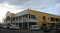
 Capitol Building (Poblacion) | ||
| ||
 Map of Pangasinan with ലിംഗായെൻ highlighted | ||
.svg) ലിംഗായെൻ Location within the ഫിലിപ്പീൻസ് | ||
| Coordinates: 16°01′00″N 120°14′00″E / 16.01667°N 120.23333°E | ||
| Country | ||
| Region | Ilocos Region (Region I) | |
| Province | Pangasinan[*] | |
| District | 2nd district of Pangasinan | |
| Founded | January 6, 1614 | |
| Barangays | 32 (see Barangays) | |
| • മേയർ | Josefina Vila Castañeda | |
| • Vice Mayor | Teng Tapia | |
| • ആകെ | 62.76 ച.കി.മീ.(24.23 ച മൈ) | |
(പിഴവ്:അസാധുവായ സമയം കാനേഷുമാരി) | ||
| • ആകെ | 1,07,728 | |
| • ജനസാന്ദ്രത | 1,700/ച.കി.മീ.(4,400/ച മൈ) | |
| ZIP code | 2401 | |
| PSGC | ||
| IDD : area code | +63 (0)75 | |
| Climate type | ഉഷ്ണമേഖലാ മൺസൂൺ കാലാവസ്ഥ | |
| Income class | 1st municipal income class | |
| Native languages | പംഗസിനാൻ ഭാഷ Ilocano ടാഗലോഗ് | |
| വെബ്സൈറ്റ് | www | |
Lingayen, ലിംഗായെൻ ഔദ്യോഗികമായി Municipality of Lingayen, (Baley na Lingayen; IlocanoIli ti Lingayen; Bayan ng Lingayen) അറിയപ്പെടുന്നു. ഫിലിപ്പൈൻസിലെ പൻഗസിനാൻ പ്രവിശ്യയിലെ ഒരു ഒന്നാം ക്ലാസ് മുനിസിപ്പാലിറ്റിയാണ്. 2015ലെ സെൻസസ് പ്രകാരം 103,278 ജനങ്ങളാണിവിടെയുള്ളത്[./Lingayen,_Pangasinan#cite_note-PSA15-01-3 [3]]
പൻഗസിനാന്റെ തലസ്ഥാനവും ആ പ്രവിശ്യയുടെ സർക്കാരിന്റെ ആസ്ഥാനവുമാണ്. ലിംഗായെൻ രണ്ടാം ലോകമഹായുദ്ധത്തിൽ ഒരു തന്ത്രപ്രധാനമായ സ്ഥലമായിരുന്നു. മുൻ പ്രസിഡന്റായ ഫിഡൽ വി. റാമോസിന്റെ ജന്മസ്ഥലവുമാണിത്.
ചരിത്രം[തിരുത്തുക]
അഗസ്തീനിയൻ മിഷണറിമാരും സ്പാനിഷ് കോൺക്വിസ്റ്റാഡോറീസ`കളും ഈ പട്ടണത്തിന്റെ രൂപരേഖ 1614ൽതയ്യാറാക്കി. ഈ പട്ടണം സ്ഥാപിച്ചു. തടിച്ച ചില പുളിമരങ്ങൾ നിന്നിരുന്ന സ്ഥലത്ത് തദ്ദേശീയരുടെ അഭിപ്രായപ്രകാരമാണ് ഈ നഗരം സ്ഥാപിച്ചത്. ഈ മരങ്ങൾ അതിഭീമമായിരുന്നുവത്രെ. അടുത്തുള്ള മറ്റു മരങ്ങൾ ഇവയെ അപേക്ഷിച്ച് വളരെ കുള്ളന്മാരെപ്പോലെ കാണപ്പെട്ടു. കാൽനടയാത്രക്കാർ ഈ മരങ്ങളെ നടന്നുപൊകുന്ന വഴിക്ക് തിരിഞ്ഞുനോക്കിക്കൊണ്ടുതന്നെ തങ്ങളുടെ കണ്ണിൽനിന്നും മറയുന്നതുവരെ കണ്ണെടുക്കാതെ പോകുമായിരുന്നു. അത്രയ്ക്കും ഈ മരങ്ങൾ ആളുകളുടെ ശ്രദ്ധ ആകർഷിച്ചിരുന്നുവത്രെ. ഏതു ദിക്കിലേയ്ക്കാണവർ നോക്കിയത് എന്ന വീട്ടുകാരുടെ ചോദ്യത്തിനു തങ്ങൾ ലിംഗായെൻ (പംഗസിനാൻ ഭാഷയിൽ)അല്ലെങ്കിൽ പിന്നോട്ട് നോക്കി എന്ന ഉത്തരം നൽകി. ഇങ്ങനെയാണ് ഈ സ്ഥലത്തിനു ഈ പേർ വന്നതെന്നു ഐതിഹ്യം.[3][4]
ലിംഗായെൻ പംഗസിനാന്റെ തലസ്ഥാനമായി പിന്നീടു മാറി.
രണ്ടാം ലോകമഹായുദ്ധസമയത്ത് ലിംഗായെൻ ഉൾക്കടൽ സഖ്യകക്ഷികളെത്തി.അവർ ലിംഗായെനിൽ ഇറങ്ങി. അന്ന് ആക്രമണത്തിനു പുറപ്പെട്ട വിമാനങ്ങളുടെ റൺവേ ആയത് ഈ കടൽത്തീരമായിരുന്നു.
ഭൂമിശാസ്ത്രം[തിരുത്തുക]
ലിംഗായെൻ ഉൾക്കടലിൻ തീരത്താണു ലിംഗായെൻ കിടക്കുന്നത്. ആഗ്നോ നദി, ലിമാഹോങ് ചാനൽ എന്നിവയും ഇവിടെയാണ്. 62.76 ചതുരശ്ര കിലോമീറ്റർ ആണ് ഈ പ്രദേശത്തിന്റെ വിസ്തീർണ്ണം. 32 ബരങ്ഗേകൾ ഉണ്ട്. ഇതിന്റെ ഉപരിതലം പരന്നതും കൃഷിക്കും മത്സ്യബന്ധനത്തിനു യോജിച്ചതുമാണ്. ലിംഗായെൻ കാലാവസ്ഥ ഡിസംബർ മുതൽ ഫെബ്രുവരി വരെ തണുപ്പുള്ളതും, മാർച്ച് മുതൽ ഏപ്രിൽ വരെ അത്യുഷ്ണമുള്ളതും മേയ് മുതൽ ഒക്ടോബർ വരെ മഴ നിറഞ്ഞതുമാണ്.
ബരൻഗെയ്സ്[തിരുത്തുക]
ലിംഗായെൻ രാഷ്ട്രീയമായി 32 ബരൻഗെയ്കൾ ആയി തിരിച്ചിട്ടുണ്ട്.
ജനസംഖ്യ[തിരുത്തുക]
സാമൂഹ്യ-സാംസ്കാരിക വികസനം[തിരുത്തുക]
Lingayen poblacion has two portions, architecturally and culturally different from each other : Spanish and American because of the large influence of both two major colonizers.
The older portion influenced by Spanish is located in the southern part. The infrastructure that the Spanish planned was all town buildings face each other around a town plaza. The buildings include the Three Kings Parish Church and the Municipal Hall.
The American one built near the Lingayen Gulf consists of many provincial government buildings including the Provincial Capitol and Urduja House, all located in the Capitol Grounds.[5]
സമ്പദ്വ്യവസ്ഥ[തിരുത്തുക]
കൃഷി, കാലിവളർത്തൽ, മത്സ്യബന്ധനം എന്നിവയാണ് പ്രധാന തൊഴിലുകൾ
നെല്ല്, ചോളം, തക്കാളി, മാങ്ങ, തണ്ണിമത്തൻ, പച്ചക്കറികൾ എന്നിവയാണ് പ്രധാന വിളകൾ.
ലിംഗായെൻ ഉൾക്കടലിലാണ് മത്യബന്ധനകേന്ദ്രം.
മറ്റു പ്രധാന വ്യവസായങ്ങൾ: മധുരം നിറച്ച തേങ്ങ, വിനാഗിരി, മരസാമാനങ്ങൾ, മുളയുപയോഗിച്ചുള്ള വിവിധ ഉത്പന്നങ്ങൾ, നിപ, ബഗൂങ് എന്നിവ.[6]
കൃഷി[തിരുത്തുക]
3,180 hectares or 47.5% സ്ഥലത്ത് കൃഷിയാണു ചെയ്യുന്നത്. [7]
ചിത്രങ്ങൾ[തിരുത്തുക]
-
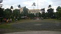
 Town Park & Capitol Grounds
 -
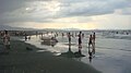
 Lingayen Beach
 -
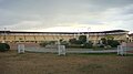
 Narciso Ramos Sports Complex & Civic Center
 -
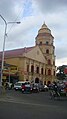
 Epiphany of the Lord Parish, Poblacion
 -


അവലംബം[തിരുത്തുക]
- ↑ "Municipality". Quezon City, Philippines: Department of the Interior and Local Government. Retrieved 31 May 2013.
- ↑ "Province: Pangasinan". PSGC Interactive. Quezon City, Philippines: Philippine Statistics Authority. Retrieved 12 നവംബർ 2016.
- ↑ "Jumpstarting Electronic Governance in Local Government Units- Lingayen (Historical Background)". Municipality of Lingayen. Archived from the original on December 10, 2004. Retrieved February 17, 2005.
- ↑ "Lingayen Official Website (Lingayen : "liñgayen")". Municipality of Lingayen. Archived from the original on January 27, 2011. Retrieved November 6, 2010.
- ↑ "Jumpstarting Electronic Governance in Local Government Units- Lingayen (Local Development)". Municipality of Lingayen. Archived from the original on December 10, 2004. Retrieved December 10, 2004.
- ↑ "Pasyalang Pangasinan: Lingayen". pasyalan.net. Archived from the original on April 29, 2009. Retrieved January 6, 2011.
- ↑ "Jumpstarting Electronic Governance in Local Government Units- Lingayen (Agricultural Profile)". Municipality of Lingayen. Archived from the original on December 10, 2004. Retrieved December 10, 2004.