
ലാൻസ്-ഔക്സ് മെഡോസ്
| L'Anse aux Meadows | |
|---|---|
 | |
| Coordinates | 51°35′42.96″N 55°31′52.4″W / 51.5952667°N 55.531222°W |
| Official name: L'Anse aux Meadows National Historic Site | |
| Type | Cultural |
| Criteria | vi |
| Designated | 1978 (2nd session) |
| Reference no. | 4 |
| Country | Canada |
| Region | Europe and North America |
| Official name: L'Anse aux Meadows National Historical Site of Canada. | |
| Designated | 28 നവംബർ 1968 |
 Location of L'Anse aux Meadows in Newfoundland | |


.jpg)
ലാൻസ്-ഔക്സ് മെഡോസ് (/ˈlænsi ˈmɛdoʊz/;[1] from the French L'Anse-aux-Méduses or "Jellyfish Cove") കാനഡയിലെ ന്യൂഫൗണ്ട്ലാൻറ് & ലാബ്രഡോർ പ്രവിശ്യയിലെ, ന്യൂഫൗണ്ട്ലാൻറ് ദ്വീപിന്റെ ഏറ്റവും വടക്കേ അറ്റത്തുള്ള ഒരു ആർക്കിയോളജിക്കൽ സൈറ്റാണ്. വടക്കേ അമേരിക്കയിലെ ഒരു നോർസ് അഥവാ വൈക്കിങ്ങ് കുടിയേറ്റകേന്ദ്രത്തിലെ ഏറ്റവും പ്രശസ്തമായ സൈറ്റ് 1960 ലാണ് കണ്ടെത്തിയത്. വർഷം 1000 ലേതെന്നു കരുതപ്പെടുന്ന ലാൻസ്-ഓക്സ് മെഡോസ്, കൊളംബസിനു മുമ്പുള്ള ട്രാൻസ്-ഓഷ്യാനിക് ബന്ധത്തിന്റെ തെളിവായി പരക്കെ അംഗീകരിക്കപ്പെട്ടിരിക്കുന്നു. ഇതേ കാലയളവിൽ ലീഫ് എറിക്സൺ ഇവിടെ സ്ഥാപിച്ചുവെന്നു വിശ്വസിക്കപ്പെടുന്ന വിൻലാൻറ് എന്ന കോളനിയുമായി, കൂടുതൽ വിശാലമായി, അമേരിക്കൻ ഭൂഖണ്ഡങ്ങളിലേയ്ക്കുള്ള നോർസ് പര്യവേക്ഷണവുമായി, ഈ പ്രദേശത്തിനുള്ള ബന്ധം അവിതർക്കിതമാണ്. 1978 ൽ യുനെസ്കോ ലോക പൈതൃകകേന്ദ്രമായി ഇതിനെ പരിഗണിച്ചിരുന്നു.
ചിത്രശാല[തിരുത്തുക]
-
 Remains of Norse settlement building, 2010 (building A)
 -
 L'Anse aux Meadows, reconstruction sod house, 2002
 -
 Entrance construction from inside, 2006
 -
 Inside of reconstruction sod house
 -
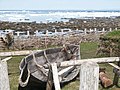 Reconstructed boat at L'Anse aux Meadows, 2002
 -
 Reenactment of a landing at L'Anse aux Meadows, 2000


അവലംബം[തിരുത്തുക]
- ↑ Giles Milton (26 August 2003). "Brave new world of the Vikings". Daily Mail. Retrieved 2014-02-02.
| Western | |
|---|---|
| Eastern | |
| Northern | |
| Tentative List | |
| Former |
|