
മൗണ്ട് മെരു
| മൌണ്ട് മെരു | |
|---|---|
 Mount Meru, 2012 | |
| ഉയരം കൂടിയ പർവതം | |
| Elevation | 4,562.13 m (14,967.6 ft) [1] |
| Prominence | 3,170 m (10,400 ft) [1] Ranked 72nd |
| Isolation | 70 km (43 mi) |
| Listing | Ultra |
| Coordinates | 3°14′48″S 36°44′54″E / 3.24667°S 36.74833°E [1] |
| ഭൂമിശാസ്ത്രപരമായ പ്രത്യേകതകൾ | |
 മൌണ്ട് മെരു Location in Tanzania | |
| സ്ഥാനം | Arusha Region, Tanzania |
| ഭൂവിജ്ഞാനീയം | |
| Mountain type | Stratovolcano |
| Last eruption | October to December 1910[2] |
| Climbing | |
| First ascent | 1904 by Fritz Jäger[3] |
| Easiest route | Hike |
മൗണ്ട് മെരു, ടാൻസാനിയയിൽ കിളിമഞ്ചാരോ പർവ്വതത്തിന് ഏകദേശം 70 കിലോമീറ്റർ (43 മൈൽ) പടിഞ്ഞാറായി സ്ഥിതിചെയ്യുന്നതും നിഷ്ക്രിയമായിക്കിടക്കുന്നതുമായ സ്ട്രാറ്റോവോൾക്കാനോ വിഭാഗത്തിൽപ്പെട്ട ഒരു അഗ്നിപർവ്വതമാണ്. സമുദ്രനിരപ്പിൽ നിന്നും 4,562.13 മീറ്റർ (14,968 അടി) ഉയരത്തിൽ സ്ഥിതിചെയ്യന്ന മൗണ്ട് മെരു, കിളിമഞ്ചാരോ പർവ്വതത്തിൽനിന്ന് തെളിഞ്ഞ ദിവസങ്ങളിൽ വ്യക്തമായി കാണാവുന്നതാണ്. ആഫ്രിക്കയിലെ അഞ്ചാമത്തെ വലിയ കൊടുമുടിയാണിത്.
ചിത്രശാല[തിരുത്തുക]
-
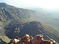 Ash cone
 -
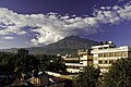 Overlooking Arusha
 -
 Little Meru Peak (3,820m)
 -
 Socialist Peak (4,562m)
 -
 A stream
 -
 Topography of Mount Meru
 -
 Mount Meru and Ngurdoto Crater (image top) from space
 -
 Mt Meru from Momella gate
 -
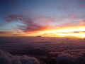 Sunrise on Mt Kili from the summit of Mt Meru


അവലംബം[തിരുത്തുക]
- ↑ 1.0 1.1 1.2 Africa Ultra-Prominences Peaklist.org. Retrieved 2011-11-22.
- ↑ "Meru". Global Volcanism Program. Smithsonian Institution.
- ↑ Mount Meru at SummitPost.org