ബൻടാല ദേശീയോദ്യാനം
| ബൻടാല ദേശീയോദ്യാനം | |
|---|---|
ഐ.യു.സി.എൻ. ഗണം II (ദേശീയോദ്യാനം) | |
 Sunset near Kirinda | |
| Location | Southern Province, Sri Lanka |
| Nearest city | Hambantota |
| Coordinates | 6°12′50″N 81°13′30″E / 6.21389°N 81.22500°E |
| Area | 3,339.38 hectares (12.8934 sq mi) after regazzetting in 2004, originally of 6,216 hectares (24.00 sq mi) |
| Established | 1969 (Sanctuary) 1993 (National park) |
| Governing body | Department of Wildlife Conservation |
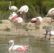
ബൻടാല ദേശീയോദ്യാനം ശ്രീലങ്കയിലെ ഹമ്പൻടോട്ടയിൽ നിന്നും 15 കിലോമീറ്റർ ദൂരത്തിൽ സ്ഥിതിചെയ്യുന്ന ദേശീയോദ്യാനങ്ങളിലൊന്നാണിത്. ഈ ദേശീയോദ്യാനത്തിലെ ബൻടാല തുറമുഖ പ്രദേശത്ത് കൂട്ടംകൂടുന്ന197 വർഗ്ഗത്തിൽപ്പെട്ട പക്ഷികളിൽ ദേശാടനപക്ഷിയായ വലിയ അരയന്നക്കൊക്കുകളുടെ വലിയകൂട്ടം ഇവിടെ കാണപ്പെടുന്നു.[1] 1969-ൽ ബൻടാലയെ വന്യജീവിസങ്കേതമായി നാമനിർദ്ദേശം ചെയ്തു. 1993 ജനുവരി 4 ന് ഇതിനെ ദേശീയോദ്യാനമായി മാറ്റപ്പെടുകയും ചെയ്തു.[2]1991-ൽ റാംസർ റാംസർ ഉടമ്പടി പ്രകാരം ശ്രീലങ്കയിലെ ആദ്യത്തെ തണ്ണീർത്തടമായി ബൻടാലയെ പ്രഖ്യാപിക്കപ്പെട്ടു. 2005-ൽ ഈ ദേശീയോദ്യാനത്തെ ശ്രീലങ്കയിലെ നാലാമത്തെ ബയോസ്ഫിയർ റിസർവ് ആയി യുനെസ്കോ നാമനിർദ്ദേശം ചെയ്തു. [3]കൊളംബോയിൽ നിന്നും 245 കിലോമീറ്റർ തെക്കു-കിഴക്കായി ഈ ദേശീയോദ്യാനം സ്ഥിതിചെയ്യുന്നു.[4]

ചരിത്രം[തിരുത്തുക]
ബൻടാലയെ 1969 ഡിസംബർ 5 ന് വന്യമൃഗസങ്കേതമായി പ്രഖ്യാപിക്കപ്പെട്ടു.[5]1993 ജനുവരി 4 ന് ഇതിനെ 6,216 ചതുരശ്രകിലോമീറ്റർ വിസ്തീർണ്ണം ഉള്ള ദേശീയോദ്യാനമായി ഉയർത്തി.[6] എങ്ങനെ ആയിരുന്നാലും 2004-ൽ ഈ ദേശീയോദ്യാനം 3,698 ചതുരശ്രകിലോമീറ്റർ വിസ്തീർണ്ണം ആയി ചുരുങ്ങി.1991-ൽ ബൻടാലയെ റാംസർ തണ്ണീർത്തടമായി നാമനിർദ്ദേശം ചെയ്തു. 2006 ജനുവരിയിൽ 3,339.38 ഹെക്ടർ പ്രദേശമുള്ള ബൻടാലയെയും ചുറ്റുമുള്ള പ്രദേശങ്ങളെയും ചേർത്ത് വിൽമണ്ണ സങ്കേതമായി പ്രഖ്യാപിക്കപ്പെട്ടു.
സസ്യജന്തുജാലങ്ങൾ[തിരുത്തുക]
ചിത്രശാല[തിരുത്തുക]
-
വലിയ അരയന്നക്കൊക്ക്
അവലംബം[തിരുത്തുക]
- ↑ "Wetland Cluster within Bundala National Park". Sri Lanka Wetlands Information and Database. IWMI. Archived from the original on 15 August 2011. Retrieved 10 September 2010.
- ↑ (in Sinhalese) Senarathna, P.M. (2005). Sri Lankawe wananthara (1st ed.). Sarasavi publishers. pp. 197–198. ISBN 955-573-401-1.
- ↑ "Twenty-three New Biosphere Reserves Added to UNESCO's Man and the Biosphere (MAB) Network". unesco.org. UNESCO. 29 June 2005. Archived from the original on 3 February 2009. Retrieved 20 May 2009.
- ↑ Senarathna, P. M. (2004). Sri Lankawe Jathika Vanodhyana [National Parks of Sri Lanka] (in Sinhala). Sarasavi Publishers. p. 195. ISBN 955-573-346-5.
- ↑ Green, Michael J. B. (1990). IUCN directory of South Asian protected areas. IUCN. pp. 198–201. ISBN 978-2-8317-0030-4.
- ↑ The National Atlas of Sri Lanka. Department of Survey. 2007. p. 88. ISBN 955-9059-04-1.
പുറത്തേയ്ക്കുള്ള കണ്ണി[തിരുത്തുക]
- Matsuno, Y; W. van der Hoek; M. Ranawake, eds. (1998). "Irrigation water management and the Bundala National Park Proceedings of the workshop on water quality of the Bundala Lagoons" (PDF). International Water Management Institute.
{{cite journal}}: Cite journal requires|journal=(help) - Perera, Nishanthi (2007). "An Overview of Bundala National Park: An exceptional wetland facing multitude of problems" (PDF). Siyoth. Field Ornithology Group of Sri Lanka. 2 (1): 4–8. Archived from the original (PDF) on 2011-07-23. Retrieved 2018-02-07.


