
പ്രമാണം:Zuid-Holland position.svg

ഈ SVG പ്രമാണത്തിന്റെ PNG പ്രിവ്യൂവിന്റെ വലിപ്പം: 200 × 236 പിക്സലുകൾ. മറ്റ് റെസലൂഷനുകൾ: 203 × 240 പിക്സലുകൾ | 407 × 480 പിക്സലുകൾ | 651 × 768 പിക്സലുകൾ | 868 × 1,024 പിക്സലുകൾ | 1,736 × 2,048 പിക്സലുകൾ.
പൂർണ്ണ വലിപ്പം (എസ്.വി.ജി. പ്രമാണം, നാമമാത്രമായ 200 × 236 പിക്സലുകൾ, പ്രമാണത്തിന്റെ വലിപ്പം: 158 കെ.ബി.)
| ഈ പ്രമാണം വിക്കിമീഡിയ കോമൺസിൽ നിന്നുള്ളതാണ്. പ്രമാണത്തെക്കുറിച്ചുള്ള വിവരണം താഴെ കൊടുത്തിരിക്കുന്നു.
|
ചുരുക്കം
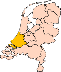
| വിവരണം | Location of the province of South-Holland (South Holland) in the Netherlands. |
| തീയതി | |
| സ്രോതസ്സ് | Own work, based on freely available GIS data |
| സ്രഷ്ടാവ് | User:Mtcv |
| അനുമതി (ഈ പ്രമാണത്തിന്റെ പുനരുപയോഗം) |
Data: attribution required; my work: PD |
| മറ്റു പതിപ്പുകൾ | I attempted to make an svg version of Image:Zuid Holland-Position.png (with less simplified boundaries) |
Clickable version

അനുമതി

|
ഈ പ്രമാണത്തിന്റെ പകർപ്പവകാശ ഉടമസ്ഥാവകാശം ഉള്ളയാളായ, Centraal Bureau voor de Statistiek, പകർപ്പവകാശ ഉടമസ്ഥാവകാശമുള്ളയാളെ ശരിയായ വിധത്തിൽ പരാമർശിച്ചിരിക്കണം എന്ന നിബന്ധനയോടെ ഏതൊരുപയോഗത്തിനും ആരേയും അനുവദിച്ചിരിക്കുന്നു. പുനർവിതരണമോ, വ്യുൽപ്പന്ന സൃഷ്ടിയോ, വ്യാപാരോപയോഗമോ, മറ്റുപയോഗമോ സാദ്ധ്യമാണ്. |
കടപ്പാട്:
|
| Annotations | This image is annotated: View the annotations at Commons |


പ്രമാണ നാൾവഴി
ഏതെങ്കിലും തീയതി/സമയ കണ്ണിയിൽ ഞെക്കിയാൽ പ്രസ്തുതസമയത്ത് ഈ പ്രമാണം എങ്ങനെയായിരുന്നു എന്നു കാണാം.
| തീയതി/സമയം | ലഘുചിത്രം | അളവുകൾ | ഉപയോക്താവ് | അഭിപ്രായം | |
|---|---|---|---|---|---|
| നിലവിലുള്ളത് | 17:21, 2 മാർച്ച് 2019 | | 200 × 236 (158 കെ.ബി.) | Thayts | update |
| 00:49, 3 ഒക്ടോബർ 2006 |  | 200 × 236 (158 കെ.ബി.) | Mtcv | {{Information| |Description=Location of the province of Noord-Holland (North Holland) in the Netherlands. |Source=Own work, based on freely available GIS data |Date=2006-10-03 |Author=User:Mtcv |Permission=Data: attribution required; my work: PD |othe |
പ്രമാണത്തിന്റെ ഉപയോഗം
താഴെ കാണുന്ന 2 താളുകളിൽ ഈ ചിത്രം ഉപയോഗിക്കുന്നു:
പ്രമാണത്തിന്റെ ആഗോള ഉപയോഗം
താഴെ കൊടുത്തിരിക്കുന്ന മറ്റ് വിക്കികൾ ഈ പ്രമാണം ഉപയോഗിക്കുന്നു:
- ar.wikipedia.org സംരംഭത്തിലെ ഉപയോഗം
- روتردام
- لاهاي
- جنوب هولندا
- لايدن
- دلفت
- خاودا
- زوترمير
- سخيدام
- قالب:بلديات جنوب هولندا
- خوريكوم
- خوريه- أوفرفلاكيه
- كاتفايك
- ماسلاوس
- فلاردينجن
- دوردريخت
- ليسه
- ألبلاسردام
- ألبراندزفارد
- ألفن آن دن راين
- باريندريخت
- كرمبنيرفارد
- نيسافارد
- بيننيماس
- بوديخرافن-ريودايك
- بريله
- كابيلا آن دن آيسل
- كرومستراين
- خيسينلاندن
- هاردينكسفيلد- خيسيندام
- هيليفوتسلاوس
- هندريك- إيدو- أمباخت
- هيليخوم
- كاخ آن براسم
- كوريندايك
- كريمبن آن دن آيسل
- لانسينجيرلاند
- ليردام
- لايدردورب
- لايتسيندام- فوربورخ
- ميدن- دلفلاند
- مولنفارد
- نيوكوب
- نوردفايك
- نوردفايكرهاوت
- أوخستخيست
- آود- بايرلاند
- آودركيرك
- بابندريخت
- باين آكر- نوتدورب
- ريدركيرك
ഈ പ്രമാണത്തിന്റെ കൂടുതൽ ആഗോള ഉപയോഗം കാണുക.