
പ്രമാണം:USA Hawaii relief location map.svg

പൂർണ്ണ വലിപ്പം (എസ്.വി.ജി. പ്രമാണം, നാമമാത്രമായ 1,441 × 935 പിക്സലുകൾ, പ്രമാണത്തിന്റെ വലിപ്പം: 317 കെ.ബി.)
| ഈ പ്രമാണം വിക്കിമീഡിയ കോമൺസിൽ നിന്നുള്ളതാണ്. പ്രമാണത്തെക്കുറിച്ചുള്ള വിവരണം താഴെ കൊടുത്തിരിക്കുന്നു.
|
ചുരുക്കം
| വിവരണം |
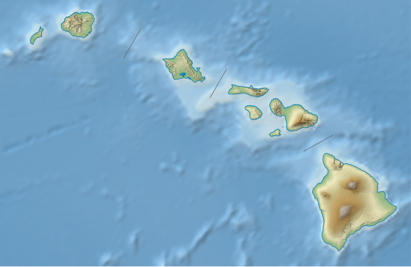
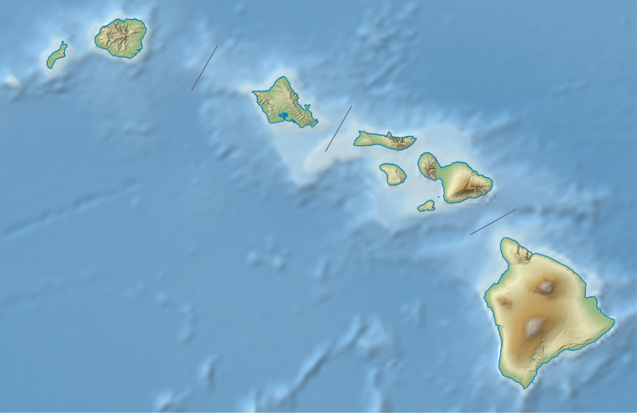
Quadratische Plattkarte, N-S-Streckung 107 %. Geographische Begrenzung der Karte:
Equirectangular projection, N/S stretching 107 %. Geographic limits of the map:
|
| തീയതി | |
| സ്രോതസ്സ് |
own work, using
|
| സ്രഷ്ടാവ് | NordNordWest |
| മറ്റു പതിപ്പുകൾ |
|


|
This map has been made or improved in the German Kartenwerkstatt (Map Lab). You can propose maps to improve as well.
|
അനുമതി
Usage of this file with:

explanatory notes: Legally binding is only the full legalcode. For a free usage I recommend to respect the following licence conditions:
1. Provide my name as given above: NordNordWest,
2. a copy of, or the URI for, the applicable license: https://creativecommons.org/licenses/by-sa/3.0/de/legalcode,
3. the title of the work,
4. in the case of an adaptation, a credit identifying the use of the work in the adaptation.
This license and the rights granted hereunder will terminate automatically upon any breach by you of the terms of this license. Any of the above conditions can be waived if you get permission from the copyright holder. If you have questions or wish differing conditions, please contact me through nnwest or my discussion page ![]() t-online.de
t-online.de
- താങ്കൾക്കുള്ള സ്വാതന്ത്ര്യങ്ങൾ:
- പങ്ക് വെയ്ക്കൽ – കൃതി പകർത്താനും, വിതരണം ചെയ്യാനും, പ്രസരിപ്പിക്കാനും
- പുനഃമിശ്രണം ചെയ്യൽ – കൃതി അനുയുക്തമാക്കാൻ
- താഴെ പറയുന്ന ഉപാധികൾ പാലിക്കുക:
- കടപ്പാട് – രചയിതാവോ അനുമതിയുള്ളയാളോ വ്യക്തമാക്കിയിട്ടുള്ള വിധത്തിൽ കൃതിയ്ക്കുള്ള കടപ്പാട് താങ്കൾ നൽകിയിരിക്കണം. താങ്കൾക്കിത് ഏത് വിധത്തിൽ വേണമെങ്കിലും ചെയ്യാവുന്നതാണ്, പക്ഷേ അത് അവർ താങ്കളേയോ താങ്കളുടെ ഉപയോഗത്തേയോ അടിച്ചേൽപ്പിച്ചതു പോലെയാവരുത്.
- ഇതു പോലെ പങ്ക് വെയ്ക്കുക – ഈ സൃഷ്ടിയെ പുനഃമിശ്രണം ചെയ്തോ രൂപാന്തരപ്പെടുത്തിയോ അടിസ്ഥാനപ്പെടുത്തിയോ ഉണ്ടാക്കുന്നവ; താങ്കളുടെ സംഭാവനയടക്കമുള്ള സൃഷ്ടി യഥാർത്ഥ സൃഷ്ടിയുടെ അതേ അല്ലെങ്കിൽ അനുരൂപമായ ഉപയോഗാനുമതിയിൽ മാത്രമേ താങ്കൾ വിതരണം ചെയ്യാവൂ.

പ്രമാണ നാൾവഴി
ഏതെങ്കിലും തീയതി/സമയ കണ്ണിയിൽ ഞെക്കിയാൽ പ്രസ്തുതസമയത്ത് ഈ പ്രമാണം എങ്ങനെയായിരുന്നു എന്നു കാണാം.
| തീയതി/സമയം | ലഘുചിത്രം | അളവുകൾ | ഉപയോക്താവ് | അഭിപ്രായം | |
|---|---|---|---|---|---|
| നിലവിലുള്ളത് | 19:22, 3 ഓഗസ്റ്റ് 2013 | | 1,441 × 935 (317 കെ.ബി.) | NordNordWest | brighter |
| 19:10, 3 ഓഗസ്റ്റ് 2013 |  | 1,441 × 935 (331 കെ.ബി.) | NordNordWest | {{Information |Description= {{de|Positionskarte von Hawaii, USA}} Quadratische Plattkarte, N-S-Streckung 107 %. Geographische Begrenzung der Karte: * N: 22.4° N * S: 18.7° N * W: 160.7° W * O: 154.6° W {{en|Location map o... |
പ്രമാണത്തിന്റെ ഉപയോഗം
പ്രമാണത്തിന്റെ ആഗോള ഉപയോഗം
താഴെ കൊടുത്തിരിക്കുന്ന മറ്റ് വിക്കികൾ ഈ പ്രമാണം ഉപയോഗിക്കുന്നു:
- ar.wikipedia.org സംരംഭത്തിലെ ഉപയോഗം
- ast.wikipedia.org സംരംഭത്തിലെ ഉപയോഗം
- azb.wikipedia.org സംരംഭത്തിലെ ഉപയോഗം
- az.wikipedia.org സംരംഭത്തിലെ ഉപയോഗം
- bg.wikipedia.org സംരംഭത്തിലെ ഉപയോഗം
- bn.wikipedia.org സംരംഭത്തിലെ ഉപയോഗം
- ca.wikipedia.org സംരംഭത്തിലെ ഉപയോഗം
- ceb.wikipedia.org സംരംഭത്തിലെ ഉപയോഗം
- ce.wikipedia.org സംരംഭത്തിലെ ഉപയോഗം
- ckb.wikipedia.org സംരംഭത്തിലെ ഉപയോഗം
- cs.wikipedia.org സംരംഭത്തിലെ ഉപയോഗം
- de.wikipedia.org സംരംഭത്തിലെ ഉപയോഗം
ഈ പ്രമാണത്തിന്റെ കൂടുതൽ ആഗോള ഉപയോഗം കാണുക.