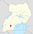
പ്രമാണം:Lyantonde District in Uganda.svg

Page contents not supported in other languages.
വിക്കിപീഡിയ, ഒരു സ്വതന്ത്ര വിജ്ഞാനകോശം.

പൂർണ്ണ വലിപ്പം(എസ്.വി.ജി. പ്രമാണം, നാമമാത്രമായ 1,441 × 1,466 പിക്സലുകൾ, പ്രമാണത്തിന്റെ വലിപ്പം: 366 കെ.ബി.)

ചുരുക്കം

Description
English: The location of Lyantonde District in Uganda, showing district boundaries as they stood in June 2017. For other districts, see Category:SVG locator maps of Districts in Uganda (location map scheme). This map may be incomplete, and may contain errors. Don't rely solely on it for navigation. In particular, note that this map overlays a spherical pseudo-mercator projection on an equirectangular projection; it is far from technically perfect.
 
വെക്റ്റർ ചിത്രം സൃഷ്ടിച്ചത് Inkscape ഉപയോഗിച്ചാണ് .
തീയതി
സ്രോതസ്സ്

Derivative of:

സ്രഷ്ടാവ്
OpenStreetMap contributors, Jarry1250, NordNordWest
അനുമതി
(ഈ പ്രമാണത്തിന്റെ പുനരുപയോഗം)
w:ml:ക്രിയേറ്റീവ് കോമൺസ്
കടപ്പാട് ഇതു പോലെ പങ്ക് വെയ്ക്കുക
ഈ പ്രമാണത്തിന് അനുമതി നൽകപ്പെട്ടിരിക്കുന്നത് ക്രിയേറ്റീവ് കോമൺസ് ആട്രിബ്യൂഷൻ-ഷെയർ എലൈക് 3.0 അൺപോർട്ടഡ് അനുവാദപത്ര പ്രകാരമാണ്.
കടപ്പാട്: © OpenStreetMap contributors, Jarry1250, NordNordWest/Wikipedia
താങ്കൾക്കുള്ള സ്വാതന്ത്ര്യങ്ങൾ:
  • പങ്ക് വെയ്ക്കൽ – കൃതി പകർത്താനും, വിതരണം ചെയ്യാനും, പ്രസരിപ്പിക്കാനും
  • പുനഃമിശ്രണം ചെയ്യൽ – കൃതി അനുയുക്തമാക്കാൻ
താഴെ പറയുന്ന ഉപാധികൾ പാലിക്കുക:
  • കടപ്പാട് – രചയിതാവോ അനുമതിയുള്ളയാളോ വ്യക്തമാക്കിയിട്ടുള്ള വിധത്തിൽ കൃതിയ്ക്കുള്ള കടപ്പാട് താങ്കൾ നൽകിയിരിക്കണം. താങ്കൾക്കിത് ഏത് വിധത്തിൽ വേണമെങ്കിലും ചെയ്യാവുന്നതാണ്, പക്ഷേ അത് അവർ താങ്കളേയോ താങ്കളുടെ ഉപയോഗത്തേയോ അടിച്ചേൽപ്പിച്ചതു പോലെയാവരുത്.
  • ഇതു പോലെ പങ്ക് വെയ്ക്കുക – ഈ സൃഷ്ടിയെ പുനഃമിശ്രണം ചെയ്തോ രൂപാന്തരപ്പെടുത്തിയോ അടിസ്ഥാനപ്പെടുത്തിയോ ഉണ്ടാക്കുന്നവ; താങ്കളുടെ സംഭാവനയടക്കമുള്ള സൃഷ്ടി യഥാർത്ഥ സൃഷ്ടിയുടെ അതേ അല്ലെങ്കിൽ അനുരൂപമായ ഉപയോഗാനുമതിയിൽ മാത്രമേ താങ്കൾ വിതരണം ചെയ്യാവൂ.
This work contains information from OpenStreetMap, which is made available under the Open Database License (ODbL).

The ODbL does not require any particular license for maps produced from ODbL data. Prior to 1 August 2020, map tiles produced by the OpenStreetMap Foundation were licensed under the CC-BY-SA-2.0 license. Maps produced by other people may be subject to other licences.

 Geotemporal data
Map location Lyantonde District, Uganda
Spatial reference system equirectangular
Bounding box
N: 4.5°N
W: 29.2°E E: 35.3°E
S: 1.7°S
Georeferencing Georeference the map in Wikimaps Warper If inappropriate please set warp_status = skip to hide.

തലവാചകങ്ങൾ

ഈ പ്രമാണം എന്തിനെ പ്രതിനിധീകരിക്കുന്നുവെന്ന ഒറ്റവരി വിശദീകരണം ചേർക്കുക

ഈ പ്രമാണത്തിൽ ചിത്രീകരിച്ചിരിക്കുന്ന ഇനങ്ങൾ

സൃഷ്ടിയിലുള്ളത്

പ്രമാണ നാൾവഴി

ഏതെങ്കിലും തീയതി/സമയ കണ്ണിയിൽ ഞെക്കിയാൽ പ്രസ്തുതസമയത്ത് ഈ പ്രമാണം എങ്ങനെയായിരുന്നു എന്നു കാണാം.

തീയതി/സമയംലഘുചിത്രംഅളവുകൾഉപയോക്താവ്അഭിപ്രായം
നിലവിലുള്ളത്21:05, 25 ജൂൺ 201721:05, 25 ജൂൺ 2017-ലെ പതിപ്പിന്റെ ലഘുചിത്രം1,441 × 1,466 (366 കെ.ബി.)Jarry1250pattypan 17.05

താഴെ കാണുന്ന താളിൽ ഈ ചിത്രം ഉപയോഗിക്കുന്നു:

പ്രമാണത്തിന്റെ ആഗോള ഉപയോഗം

താഴെ കൊടുത്തിരിക്കുന്ന മറ്റ് വിക്കികൾ ഈ പ്രമാണം ഉപയോഗിക്കുന്നു:

മെറ്റാഡാറ്റ

"https://ml.wikipedia.org/wiki/പ്രമാണം:Lyantonde_District_in_Uganda.svg" എന്ന താളിൽനിന്ന് ശേഖരിച്ചത്