പ്രമാണം:Location greek ancient.png

Page contents not supported in other languages.
വിക്കിപീഡിയ, ഒരു സ്വതന്ത്ര വിജ്ഞാനകോശം.

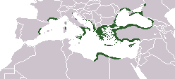
Location_greek_ancient.png(248 × 113 പിക്സൽ, പ്രമാണത്തിന്റെ വലിപ്പം: 4 കെ.ബി., മൈം തരം: image/png)

ചുരുക്കം

വിവരണം
English: Locator map depicting the ancient Greek world, c. 550 BC
തീയതി
സ്രോതസ്സ് Self-created, after http://www.wwnorton.com/nrl/english/nawol/maps/MAP7GRCO.JPG
സ്രഷ്ടാവ് User:ChrisO
അനുമതി
(ഈ പ്രമാണത്തിന്റെ പുനരുപയോഗം)
Public domain ഈ സൃഷ്ടിയുടെ പകർപ്പവകാശ ഉടമയായ ഞാൻ, ഈ സൃഷ്ടി പൊതുസഞ്ചയത്തിൽ പ്രസിദ്ധീകരിച്ചിരിക്കുന്നു. ഇത് ആഗോള തലത്തിൽ ബാധകമാണ്.
ചില രാജ്യങ്ങളിൽ ഇത് നിയമപ്രകാരം സാദ്ധ്യമല്ലെന്ന് വന്നേക്കാം; അങ്ങനെയെങ്കിൽ:
ഈ സൃഷ്ടി, നിയമപ്രകാരം നിബന്ധനകൾ ഉണ്ടെങ്കിൽ അവയൊഴിച്ച്, യാതൊരു നിബന്ധനകളും ഇല്ലാതെ ഏതൊരാൾക്കും ഏതൊരു ഉപയോഗത്തിനും, ഉപയോഗപ്പെടുത്തുവാൻ ഞാൻ അനുവദിച്ചിരിക്കുന്നു.
മറ്റു പതിപ്പുകൾ
ഈ ചിത്രത്തിന്റെ ഒരു വെക്റ്റർ പതിപ്പ് (SVG) File:Location greek ancient.svg ലഭ്യമാണ്.
ഈ ചിത്രത്തിനേക്കാൾ മികച്ച റസല്യൂഷൻ ആവശ്യമെങ്കിൽ ഈ റാസ്റ്റർ ചിത്രത്തിനു പകരം അതുപയോഗിക്കേണ്ടതാണ്.

File:Location greek ancient.png → File:Location greek ancient.svg

വെക്റ്റർ ഗ്രാഫിക്സിനെക്കുറിച്ച് കൂടുതൽ അറിയണമെന്നുണ്ടെങ്കിൽ, എസ്.വി.ജി.യിലേയ്ക്കുള്ള മാറ്റം എന്ന താൾ കാണുക.
മീഡിയവിക്കിയിൽ എസ്.വി.ജി.യ്ക്കുള്ള പിന്തുണ എന്നുമൊരു താൾ നിലവിലുണ്ട്.

മറ്റ് ഭാഷകളിൽ
Alemannisch  Bahasa Indonesia  Bahasa Melayu  British English  català  čeština  dansk  Deutsch  eesti  English  español  Esperanto  euskara  français  Frysk  galego  hrvatski  Ido  italiano  lietuvių  magyar  Nederlands  norsk bokmål  norsk nynorsk  occitan  Plattdüütsch  polski  português  português do Brasil  română  Scots  sicilianu  slovenčina  slovenščina  suomi  svenska  Tiếng Việt  Türkçe  vèneto  Ελληνικά  беларуская (тарашкевіца)  български  македонски  нохчийн  русский  српски / srpski  татарча/tatarça  українська  ქართული  հայերեն  বাংলা  தமிழ்  മലയാളം  ไทย  한국어  日本語  简体中文  繁體中文  עברית  العربية  فارسی  +/−
പുതിയ എസ്.വി.ജി. ചിത്രം

തലവാചകങ്ങൾ

ഈ പ്രമാണം എന്തിനെ പ്രതിനിധീകരിക്കുന്നുവെന്ന ഒറ്റവരി വിശദീകരണം ചേർക്കുക

ഈ പ്രമാണത്തിൽ ചിത്രീകരിച്ചിരിക്കുന്ന ഇനങ്ങൾ

സൃഷ്ടിയിലുള്ളത്

17 സെപ്റ്റംബർ 2006

പ്രമാണ നാൾവഴി

ഏതെങ്കിലും തീയതി/സമയ കണ്ണിയിൽ ഞെക്കിയാൽ പ്രസ്തുതസമയത്ത് ഈ പ്രമാണം എങ്ങനെയായിരുന്നു എന്നു കാണാം.

(ഏറ്റവും പുതിയവ | ഏറ്റവും പഴയവ) പുതിയ 10 | എണ്ണം കാണുക (10 | 20 | 50 | 100 | 250 | 500)
തീയതി/സമയംലഘുചിത്രംഅളവുകൾഉപയോക്താവ്അഭിപ്രായം
നിലവിലുള്ളത്16:20, 27 സെപ്റ്റംബർ 202116:20, 27 സെപ്റ്റംബർ 2021-ലെ പതിപ്പിന്റെ ലഘുചിത്രം248 × 113 (4 കെ.ബി.)Deji Olajide1999Added the missing regions of Orestis, Elimiotis, Eordaia and Tymphaea + cleared up the Greek colonies in Thrace.
09:22, 23 ജനുവരി 201809:22, 23 ജനുവരി 2018-ലെ പതിപ്പിന്റെ ലഘുചിത്രം248 × 113 (4 കെ.ബി.)MaphobbyistAdded Colchis.
16:15, 26 ജൂൺ 201416:15, 26 ജൂൺ 2014-ലെ പതിപ്പിന്റെ ലഘുചിത്രം248 × 113 (6 കെ.ബി.)SilentResidentAdded missing kingdom of Epirus
10:55, 29 ഡിസംബർ 201210:55, 29 ഡിസംബർ 2012-ലെ പതിപ്പിന്റെ ലഘുചിത്രം248 × 113 (5 കെ.ബി.)GepgepgepAggiunta l'area di colonizzazione greca dell'Adriatico, che mancava completamente
17:22, 5 സെപ്റ്റംബർ 201117:22, 5 സെപ്റ്റംബർ 2011-ലെ പതിപ്പിന്റെ ലഘുചിത്രം248 × 113 (5 കെ.ബി.)Spesh531Showing borders that are recognized. Still showing unrecognized countries for a reference of where Ancient Greek was. It was also about the shape of the lands, as Greek Islands where either not shown correctly or not there at all
13:00, 5 സെപ്റ്റംബർ 201113:00, 5 സെപ്റ്റംബർ 2011-ലെ പതിപ്പിന്റെ ലഘുചിത്രം248 × 113 (4 കെ.ബി.)MaphobbyistPfrevious user Saguamundi is right. International borders, and NOT disputed borders must be shown. Nor is this about the present but about historical Greek settlements. There is no place for current politics for a historical map.
22:28, 4 സെപ്റ്റംബർ 201122:28, 4 സെപ്റ്റംബർ 2011-ലെ പതിപ്പിന്റെ ലഘുചിത്രം248 × 113 (5 കെ.ബി.)Spesh531Reverted to version as of 01:56, 11 May 2011 The border were fine, your showing territories where some are unrecognizable
22:21, 4 സെപ്റ്റംബർ 201122:21, 4 സെപ്റ്റംബർ 2011-ലെ പതിപ്പിന്റെ ലഘുചിത്രം248 × 113 (5 കെ.ബി.)Spesh531Reverted to version as of 01:56, 11 May 2011 The border were fine, your showing territories where some are unrecognizable
21:26, 4 സെപ്റ്റംബർ 201121:26, 4 സെപ്റ്റംബർ 2011-ലെ പതിപ്പിന്റെ ലഘുചിത്രം248 × 113 (4 കെ.ബി.)SaguamundiSame map but with internationally recognized borders.
01:56, 11 മേയ് 201101:56, 11 മേയ് 2011-ലെ പതിപ്പിന്റെ ലഘുചിത്രം248 × 113 (5 കെ.ബി.)Spesh531update more to source, the current Greece was not under territory.
(ഏറ്റവും പുതിയവ | ഏറ്റവും പഴയവ) പുതിയ 10 | എണ്ണം കാണുക (10 | 20 | 50 | 100 | 250 | 500)

ഈ പ്രമാണം വിക്കിയിലെ താളുകളിലൊന്നിലും ഉപയോഗിക്കുന്നില്ല.

പ്രമാണത്തിന്റെ ആഗോള ഉപയോഗം

താഴെ കൊടുത്തിരിക്കുന്ന മറ്റ് വിക്കികൾ ഈ പ്രമാണം ഉപയോഗിക്കുന്നു:

മെറ്റാഡാറ്റ

"https://ml.wikipedia.org/wiki/പ്രമാണം:Location_greek_ancient.png" എന്ന താളിൽനിന്ന് ശേഖരിച്ചത്