പ്രമാണം:ISS029-E-008032 Fires along the Rio Xingu - Brazil.jpg

Page contents not supported in other languages.
വിക്കിപീഡിയ, ഒരു സ്വതന്ത്ര വിജ്ഞാനകോശം.

പൂർണ്ണ വലിപ്പം(4,288 × 2,848 പിക്സൽ, പ്രമാണത്തിന്റെ വലിപ്പം: 8.76 എം.ബി., മൈം തരം: image/jpeg)

ചുരുക്കം

വിവരണം
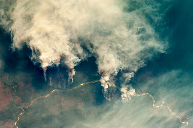
English: Slash-and-burn forest clearing along the Rio Xingu (Xingu River) in the state of Mato Grosso, Brazil.


International Space Station InsigniaISS Crew Earth Observations: ISS029-E-8032International Space Station Insignia
Identification
Mission ISS029 (Expedition 29)
Roll E
Frame 8032
Country or Geographic Name BRAZIL
Features RIO XINGU, FOREST, AMAZONIA, SMOKE PLUMES
Center Point Latitude -11.8° N
Center Point Longitude -53.6° E
Camera
Camera Tilt 28°
Camera Focal Length 200 mm
Camera Nikon D2Xs
Film 4288 x 2848 pixel CMOS sensor, RGBG imager color filter.
Quality
Percentage of Cloud Cover 0-10%
Nadir What is Nadir?
Date 2011-09-17
Time 20:13:03
Nadir Point Latitude -12.8° N
Nadir Point Longitude -55.1° E
Nadir to Photo Center Direction Northeast
Sun Azimuth 277°
Spacecraft Altitude 205 nautical miles (380 km)
Sun Elevation Angle 19°
Orbit Number 1537
Original image caption
The rain forest of South America, also known as “Amazonia”—the largest such forest on Earth—has been undergoing a continual and accelerated land use conversion process into farmlands (including pasture for livestock) since the early 1960s. This process has typically been achieved by clearing of the forest using fire – “slash and burn” – followed by planting of crops. The generally infertile soils of the region make sustainable farming difficult; this drives more forest conversion into new farmland. The area of clearing can be considerable, and as the deforested regions are easily identifiable and measurable from space the rate of deforestation is likewise easy to track.

This detailed astronaut photograph illustrates slash-and-burn forest clearing along the Xingu River (Rio) in the northeast of the state of Matto Grasso, Brazil. The image was taken from the International Space Station, a platform from which astronauts can take imagery of the Earth from a variety of viewing angles. The perspective of this image allows for a striking visualization of both the horizontal position and extent of the fire lines next to the river, as well as providing a sense of the vertical structure of the smoke plumes due to the viewing angle and shadowing.

Light colored areas within the river channel are sand bars, which show that the river is in its annual low-flow/ low water stage. For a sense of scale, the Xingu River channel within the view is approximately 63 kilometers long. Rivers in Amazonia are its natural highways, which may explain why the burning is occurring right next to the Xingu River, one of Amazonia’s largest. In recent years, preservation has gained traction in the region as a result of such considerations as new valuation of the ecosystem services provided by the forest, concerns about the impact of widespread burning on global climate change, and greater sensitivity to the ethnic and biological heritage of Amazonia.

തീയതി
സ്രോതസ്സ് ISS029-E-8032
സ്രഷ്ടാവ്
  • Expedition 29 Crew
  • Image courtesy of the Image Science & Analysis Laboratory, NASA Johnson Space Center
  • Derivative work including grading, noise removal and hotpixel corrections.: Julian Herzog
മറ്റു പതിപ്പുകൾ
Public domain
നാസയുടെ ജോൺസൺ ബഹിരാകാശ കേന്ദ്രത്തിലെ, ഇമേജ് സയൻസ് ആൻഡ് അനാലിസിസ് പരീക്ഷണശാല നിർമ്മിച്ചതായതിനാൽ ഈ പ്രമാണം പൊതുസഞ്ചയത്തിൽ പെടുന്നു. "മറ്റ് വിധത്തിൽ കുറിച്ചിട്ടില്ലെങ്കിൽ നാസയുടെ സൃഷ്ടികൾ പകർപ്പവകാശ സംരക്ഷിതം അല്ല" എന്നാണ് നാസയുടെ പകർപ്പവകാശ നയം വ്യക്തമാക്കുന്നത്. (നാസയുടെ പകർപ്പവകാശനയം താൾ അല്ലെങ്കിൽ ബഹിരാകാശ യാത്രികരുടെ ചിത്രങ്ങൾ ഉപയോഗിക്കുന്നതിനുള്ള നിബന്ധനകൾ). ഫോട്ടോയുടെ സ്രോതസ്സ്: ISS029-E-008032.

العربيَّة | Deutsch | English | español | français | italiano | kurdî | македонски | മലയാളം | português | sicilianu | +/−

അനുമതി

Public domain ഈ പ്രമാണം നാസ സൃഷ്ടിച്ചതായതിനാൽ പൊതുസഞ്ചയത്തിൽ വരുന്നു. "നാസ നൽകുന്ന വിവരങ്ങൾ മറ്റുവിധത്തിൽ കുറിച്ചിട്ടില്ലെങ്കിൽ പൊതുസഞ്ചയത്തിൽ വരുന്നു എന്നാണ് നാസയുടെ പകർപ്പവകാശ നയം വ്യക്തമാക്കുന്നത്". (Template:PD-USGov, നാസ പകർപ്പവകാശ നയം താൾ ഒപ്പം JPL ചിത്ര ഉപയോഗ നയം എന്നിവ കാണുക.)
മുന്നറിയിപ്പുകൾ:
  • നാസയുടെ ലോഗോകൾ, അടയാളങ്ങൾ, മുദ്രകൾ എന്നിവ അമേരിക്കൻ ഐക്യനാടുകളിലെ നിയമം 14 CFR 1221 പ്രകാരം ഉപയോഗം പരിമിതപ്പെടുത്തിയതാണ്.
  • നാസയുടെ വെബ്സൈറ്റിൽ സോവിയറ്റ് / റഷ്യൻ സ്പേസ് ഏജൻസി ഒപ്പം മറ്റ് അമേരിക്കൻ ഐക്യനാടുകളുടേതല്ലാത്ത ബഹിരാകാശ സ്ഥാപനങ്ങൾ എന്നിവ എടുത്തിട്ടുള്ള ചിത്രങ്ങൾ ധാരാളമായി കൊടുത്തിട്ടുണ്ട്. അവ പൊതുസഞ്ചയത്തിൽ വരണമെന്നില്ല.
  • ഹബിൾ ബഹിരാകാശ ദൂരദർശിനിയിൽ നിന്നുള്ള വിവരങ്ങൾ STScI പകർപ്പവകാശം വ്യക്തമാക്കി പ്രസിദ്ധീകരിച്ചിട്ടില്ലെങ്കിൽ പകർപ്പവകാശ സംരക്ഷിതമാണ്. [1] ഒപ്പം {{PD-Hubble}}, {{Cc-Hubble}}, {{Spacetelescope.org}} എന്നിവയും കാണുക.
  • SOHO (ESA & NASA) പങ്ക് പദ്ധതിയിലെ എല്ലാ ചിത്രങ്ങളും വ്യാണിജ്യപരമോ വിദ്യാഭ്യാസേതരമോ ആയ കാര്യങ്ങൾക്കുപയോഗിക്കാൻ പ്രത്യേക അനുമതി നേടിയിരിക്കണമെന്ന് ആവശ്യപ്പെടുന്നുണ്ട്. [2]
  • ഇന്നത്തെ ജ്യോതിർ ചിത്രം (Astronomy Picture of the Day - APOD) വെബ്സൈറ്റിലെ ചിത്രങ്ങൾ പകർപ്പവകാശ സംരക്ഷിതമാകാം. [3]

തലവാചകങ്ങൾ

ഈ പ്രമാണം എന്തിനെ പ്രതിനിധീകരിക്കുന്നുവെന്ന ഒറ്റവരി വിശദീകരണം ചേർക്കുക
Satellite photograph illustrating slash-and-burn forest clearing along the Xingu River in the state of Mato Grosso, Brazil

ഈ പ്രമാണത്തിൽ ചിത്രീകരിച്ചിരിക്കുന്ന ഇനങ്ങൾ

സൃഷ്ടിയിലുള്ളത്

17 സെപ്റ്റംബർ 2011

പ്രമാണ നാൾവഴി

ഏതെങ്കിലും തീയതി/സമയ കണ്ണിയിൽ ഞെക്കിയാൽ പ്രസ്തുതസമയത്ത് ഈ പ്രമാണം എങ്ങനെയായിരുന്നു എന്നു കാണാം.

തീയതി/സമയംലഘുചിത്രംഅളവുകൾഉപയോക്താവ്അഭിപ്രായം
നിലവിലുള്ളത്09:55, 27 ഏപ്രിൽ 201309:55, 27 ഏപ്രിൽ 2013-ലെ പതിപ്പിന്റെ ലഘുചിത്രം4,288 × 2,848 (8.76 എം.ബി.)Julian HerzogUser created page with UploadWizard

താഴെ കാണുന്ന 2 താളുകളിൽ ഈ ചിത്രം ഉപയോഗിക്കുന്നു:

പ്രമാണത്തിന്റെ ആഗോള ഉപയോഗം

താഴെ കൊടുത്തിരിക്കുന്ന മറ്റ് വിക്കികൾ ഈ പ്രമാണം ഉപയോഗിക്കുന്നു:

മെറ്റാഡാറ്റ

"https://ml.wikipedia.org/wiki/പ്രമാണം:ISS029-E-008032_Fires_along_the_Rio_Xingu_-_Brazil.jpg" എന്ന താളിൽനിന്ന് ശേഖരിച്ചത്