
പ്രമാണം:Flores Locator Topography.png

ഈ പ്രിവ്യൂവിന്റെ വലിപ്പം: 800 × 473 പിക്സലുകൾ. മറ്റ് റെസലൂഷനുകൾ: 320 × 189 പിക്സലുകൾ | 640 × 379 പിക്സലുകൾ | 1,024 × 606 പിക്സലുകൾ | 1,280 × 757 പിക്സലുകൾ | 2,559 × 1,514 പിക്സലുകൾ.
പൂർണ്ണ വലിപ്പം (2,559 × 1,514 പിക്സൽ, പ്രമാണത്തിന്റെ വലിപ്പം: 1.46 എം.ബി., മൈം തരം: image/png)
| ഈ പ്രമാണം വിക്കിമീഡിയ കോമൺസിൽ നിന്നുള്ളതാണ്. പ്രമാണത്തെക്കുറിച്ചുള്ള വിവരണം താഴെ കൊടുത്തിരിക്കുന്നു.
|
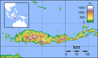
| വിവരണം | Topographic map of Flores, Indonesia. Created with GMT from SRTM data. |
| തീയതി | (UTC) |
| സ്രോതസ്സ് | |
| സ്രഷ്ടാവ് |
|
| ഇത് ഒരു മിനുക്കിയെടുത്ത ചിത്രമാണ്, യഥാർത്ഥ പതിപ്പിൽ നിന്ന് ഡിജിറ്റലായി മാറ്റങ്ങൾ വരുത്തിയിട്ടുണ്ടെന്നാണ് ഇതിനർത്ഥം. മാറ്റങ്ങൾ: croped margins. യഥാർത്ഥ പതിപ്പ് ഇവിടെ കാണാം: Flores Topography.png. മാറ്റങ്ങൾ വരുത്തിയത് Elekhh.
|
ഈ സൃഷ്ടിയുടെ പകർപ്പവകാശ ഉടമയായ ഞാൻ, താഴെ പറയുന്ന അനുമതികളിൽ ഈ സൃഷ്ടി ഇതിനാൽ പ്രസിദ്ധീകരിക്കുന്നു:
ഈ പ്രമാണത്തിന് അനുമതി നൽകപ്പെട്ടിരിക്കുന്നത് ക്രിയേറ്റീവ് കോമൺസ് ആട്രിബ്യൂഷൻ-ഷെയർ എലൈക് 3.0 അൺപോർട്ടഡ്, 2.5 സാമാന്യ, 2.0 സാമാന്യ ഒപ്പം 1.0 സാമാന്യ അനുവാദപത്രങ്ങൾ പ്രകാരമാണ്.
- താങ്കൾക്കുള്ള സ്വാതന്ത്ര്യങ്ങൾ:
- പങ്ക് വെയ്ക്കൽ – കൃതി പകർത്താനും, വിതരണം ചെയ്യാനും, പ്രസരിപ്പിക്കാനും
- പുനഃമിശ്രണം ചെയ്യൽ – കൃതി അനുയുക്തമാക്കാൻ
- താഴെ പറയുന്ന ഉപാധികൾ പാലിക്കുക:
- കടപ്പാട് – രചയിതാവോ അനുമതിയുള്ളയാളോ വ്യക്തമാക്കിയിട്ടുള്ള വിധത്തിൽ കൃതിയ്ക്കുള്ള കടപ്പാട് താങ്കൾ നൽകിയിരിക്കണം. താങ്കൾക്കിത് ഏത് വിധത്തിൽ വേണമെങ്കിലും ചെയ്യാവുന്നതാണ്, പക്ഷേ അത് അവർ താങ്കളേയോ താങ്കളുടെ ഉപയോഗത്തേയോ അടിച്ചേൽപ്പിച്ചതു പോലെയാവരുത്.
- ഇതു പോലെ പങ്ക് വെയ്ക്കുക – ഈ സൃഷ്ടിയെ പുനഃമിശ്രണം ചെയ്തോ രൂപാന്തരപ്പെടുത്തിയോ അടിസ്ഥാനപ്പെടുത്തിയോ ഉണ്ടാക്കുന്നവ; താങ്കളുടെ സംഭാവനയടക്കമുള്ള സൃഷ്ടി യഥാർത്ഥ സൃഷ്ടിയുടെ അതേ അല്ലെങ്കിൽ അനുരൂപമായ ഉപയോഗാനുമതിയിൽ മാത്രമേ താങ്കൾ വിതരണം ചെയ്യാവൂ.

|
സ്വതന്ത്ര സോഫ്റ്റ്വേർ സമിതി പ്രസിദ്ധീകരിച്ചിട്ടുള്ള ഗ്നു സ്വതന്ത്ര പ്രമാണ അനുവാദപത്രം പതിപ്പ് 1.2 അല്ലെങ്കിൽ പുതിയ പതിപ്പുകൾ പ്രകാരം; മാറ്റമില്ലാത്ത ഭാഗങ്ങളില്ലാതെ, മുൻചട്ടയിലെ എഴുത്തുകൾ ഇല്ലാതെ, പിൻചട്ടയിലെ എഴുത്തുകൾ ഇല്ലാതെ പകർത്താനും, വിതരണം ചെയ്യാനും ഒപ്പം/അല്ലെങ്കിൽ ഈ പ്രമാണത്തിൽ മാറ്റം വരുത്തുവാനും ഉള്ള അവകാശങ്ങൾ നൽകുന്നു. ഗ്നു സ്വതന്ത്ര പ്രമാണ അനുവാദപത്രം എന്ന തലക്കെട്ടിൽ അനുവാദപത്രത്തിന്റെ ഒരു പകർപ്പ് ഉൾപ്പെടുത്തിയിട്ടുണ്ട്. |
താങ്കൾക്ക് താങ്കളുടെ ഇച്ഛാനുസരണം അനുമതി തിരഞ്ഞെടുക്കാം.
യഥാർത്ഥ അപ്ലോഡ് രേഖ
This image is a derivative work of the following images:
- File:Flores_Topography.png licensed with Cc-by-sa-3.0,2.5,2.0,1.0, GFDL
- 2007-09-11T21:28:50Z Sadalmelik 2745x1665 (1468315 Bytes) {{Information |Description=Topographic map of Flores, Indonesia. Created with GMT from SRTM data. |Source=self-made |Date=Sep 11, 2007 |Author= [[User:Sadalmelik|Sadalmelik]] }} [[Category:Maps of Indonesia]] [[Category:Topo
ഡെറിവേറ്റീവ്എഫ്എക്സ് ഉപയോഗിച്ചാണ് അപ്ലോഡ് ചെയ്തത്
പ്രമാണ നാൾവഴി
ഏതെങ്കിലും തീയതി/സമയ കണ്ണിയിൽ ഞെക്കിയാൽ പ്രസ്തുതസമയത്ത് ഈ പ്രമാണം എങ്ങനെയായിരുന്നു എന്നു കാണാം.
| തീയതി/സമയം | ലഘുചിത്രം | അളവുകൾ | ഉപയോക്താവ് | അഭിപ്രായം | |
|---|---|---|---|---|---|
| നിലവിലുള്ളത് | 04:20, 1 ഫെബ്രുവരി 2010 | | 2,559 × 1,514 (1.46 എം.ബി.) | Elekhh | {{Information |Description=Topographic map of Flores, Indonesia. Created with GMT from SRTM data. |Source=*File:Flores_Topography.png |Date=2010-02-01 04:17 (UTC) |Author=*File:Flores_Topography.png: Sadalmelik *derivative |
പ്രമാണത്തിന്റെ ഉപയോഗം
താഴെ കാണുന്ന 3 താളുകളിൽ ഈ ചിത്രം ഉപയോഗിക്കുന്നു:
പ്രമാണത്തിന്റെ ആഗോള ഉപയോഗം
താഴെ കൊടുത്തിരിക്കുന്ന മറ്റ് വിക്കികൾ ഈ പ്രമാണം ഉപയോഗിക്കുന്നു:
- ar.wikipedia.org സംരംഭത്തിലെ ഉപയോഗം
- arz.wikipedia.org സംരംഭത്തിലെ ഉപയോഗം
- ban.wikipedia.org സംരംഭത്തിലെ ഉപയോഗം
- ceb.wikipedia.org സംരംഭത്തിലെ ഉപയോഗം
- en.wikipedia.org സംരംഭത്തിലെ ഉപയോഗം
- Komodo National Park
- Iliboleng
- Paluweh
- Kelimutu
- Palu'e language
- List of national parks of Indonesia
- Sikka Regency
- Ende Regency
- Ende (town)
- Maumere
- Poco Mandasawu
- Ranakah
- Lewotobi
- Leroboleng
- Mount Egon
- Ebulobo
- Inierie
- Mount Iya
- Inielika
- Wai Sano
- Sumba Strait
- Kelimutu National Park
- Larantuka
- H. Hasan Aroeboesman Airport
- Komodo International Airport
- Frans Xavier Seda Airport
- 1992 Flores earthquake and tsunami
- Ruteng
- Ngada Regency
- West Manggarai Regency
- East Flores Regency
- Manggarai Regency
- Nagekeo Regency
- East Manggarai Regency
- Labuan Bajo
- Module:Location map/data/Indonesia Flores/doc
ഈ പ്രമാണത്തിന്റെ കൂടുതൽ ആഗോള ഉപയോഗം കാണുക.