പ്രമാണം:EastJerusalemMap-es.svg

Page contents not supported in other languages.
വിക്കിപീഡിയ, ഒരു സ്വതന്ത്ര വിജ്ഞാനകോശം.

പൂർണ്ണ വലിപ്പം(എസ്.വി.ജി. പ്രമാണം, നാമമാത്രമായ 384 × 589 പിക്സലുകൾ, പ്രമാണത്തിന്റെ വലിപ്പം: 88 കെ.ബി.)

വിവരണം

[തിരുത്തുക]

Deutsch: Karte Jerusalems:
 
Westjerusalem und Skopusberg
 
Waffenstillstandslinie von 1949
 
Altstadt
 
Arabische Viertel in Ostjerusalem
 
Stadtgrenze bis 1967
 
Jüdische Viertel in Ostjerusalem
 
Stadtgrenze
 
Jüdische Gebiete im Westjordanland
 
Arabische Gebiete im Westjordanland
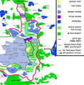
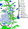
English: Map of Jerusalem:
 
West Jerusalem and Mount Scopus
 
1949 armistice line
 
Old City, fully annexed by Israel
 
East Jerusalem, occupied Arab areas, annexed by Israel
 
Pre-1967 municipal boundary
 
East Jerusalem, Jewish colonies, annexed by Israel
 
Current Israeli extended boundary of the municipality and of the district of Jerusalem
 
West Bank, Jewish colonies in the new district of Samaria and Judea (zone C)
 
West Bank, occupied Arab areas (zone A, partially controled by the Palestinian National Authority)
Español: Mapa de Jerusalén:
 
Jerusalén Oeste y Monte Scopus
 
Frontera de armisticio de 1949
 
Ciudad Vieja
 
Jerusalén Este, áreas árabes
 
Frontera anterior a 1967
 
Jerusalén Este, áreas judías
 
Frontera de Jerusalén
 
Cisjordania, áreas judías
 
Cisjordania, áreas árabes
Français : Carte de Jérusalem :
 
Jérusalem-Ouest et Mont Scopus
 
Ligne d'armistice de 1949
 
Vieille ville, entièrement annexée par Israël
 
Jérusalem-Est, secteurs arabes occupés par Israël
 
Frontière municipale avant 1967
 
Jérusalem-Est, colonies juives annexées par Israël après 1967
 
Frontière actuelle d'extension israélienne de la municipalité et du district de Jérusalem
 
Cisjordanie, colonies juives dans le nouveau district israélien de Samarie et de Judée (zone C)
 
Cisjordanie, secteurs arabes occupés (zone A, partiellement contrôlée par l'Autorité nationale palestinienne)
തീയതി
സ്രോതസ്സ്
image extraction process
ഈ ചിത്രം മറ്റൊരു ചിത്രത്തിൽ നിന്നും വെട്ടിയെടുത്തതാണ്
 : EastJerusalemMap.jpg
original file
സ്രഷ്ടാവ് Doron, Chabacano
അനുമതി
(ഈ പ്രമാണത്തിന്റെ പുനരുപയോഗം)
GNU head സ്വതന്ത്ര സോഫ്റ്റ്‌‌വേർ സമിതി പ്രസിദ്ധീകരിച്ചിട്ടുള്ള ഗ്നു സ്വതന്ത്ര പ്രമാണ അനുവാദപത്രം പതിപ്പ് 1.2 അല്ലെങ്കിൽ പുതിയ പതിപ്പുകൾ പ്രകാരം; മാറ്റമില്ലാത്ത ഭാഗങ്ങളില്ലാതെ, മുൻചട്ടയിലെ എഴുത്തുകൾ ഇല്ലാതെ, പിൻചട്ടയിലെ എഴുത്തുകൾ ഇല്ലാതെ പകർത്താനും, വിതരണം ചെയ്യാനും ഒപ്പം/അല്ലെങ്കിൽ ഈ പ്രമാണത്തിൽ മാറ്റം വരുത്തുവാനും ഉള്ള അവകാശങ്ങൾ നൽകുന്നു. ഗ്നു സ്വതന്ത്ര പ്രമാണ അനുവാദപത്രം എന്ന തലക്കെട്ടിൽ അനുവാദപത്രത്തിന്റെ ഒരു പകർപ്പ് ഉൾപ്പെടുത്തിയിട്ടുണ്ട്.
w:ml:ക്രിയേറ്റീവ് കോമൺസ്
കടപ്പാട് ഇതു പോലെ പങ്ക് വെയ്ക്കുക
ഈ പ്രമാണത്തിന് അനുമതി നൽകപ്പെട്ടിരിക്കുന്നത് ക്രിയേറ്റീവ് കോമൺസ് ആട്രിബ്യൂഷൻ-ഷെയർ എലൈക് 3.0 അൺപോർട്ടഡ് അനുവാദപത്ര പ്രകാരമാണ്.
താങ്കൾക്കുള്ള സ്വാതന്ത്ര്യങ്ങൾ:
  • പങ്ക് വെയ്ക്കൽ – കൃതി പകർത്താനും, വിതരണം ചെയ്യാനും, പ്രസരിപ്പിക്കാനും
  • പുനഃമിശ്രണം ചെയ്യൽ – കൃതി അനുയുക്തമാക്കാൻ
താഴെ പറയുന്ന ഉപാധികൾ പാലിക്കുക:
  • കടപ്പാട് – രചയിതാവോ അനുമതിയുള്ളയാളോ വ്യക്തമാക്കിയിട്ടുള്ള വിധത്തിൽ കൃതിയ്ക്കുള്ള കടപ്പാട് താങ്കൾ നൽകിയിരിക്കണം. താങ്കൾക്കിത് ഏത് വിധത്തിൽ വേണമെങ്കിലും ചെയ്യാവുന്നതാണ്, പക്ഷേ അത് അവർ താങ്കളേയോ താങ്കളുടെ ഉപയോഗത്തേയോ അടിച്ചേൽപ്പിച്ചതു പോലെയാവരുത്.
  • ഇതു പോലെ പങ്ക് വെയ്ക്കുക – ഈ സൃഷ്ടിയെ പുനഃമിശ്രണം ചെയ്തോ രൂപാന്തരപ്പെടുത്തിയോ അടിസ്ഥാനപ്പെടുത്തിയോ ഉണ്ടാക്കുന്നവ; താങ്കളുടെ സംഭാവനയടക്കമുള്ള സൃഷ്ടി യഥാർത്ഥ സൃഷ്ടിയുടെ അതേ അല്ലെങ്കിൽ അനുരൂപമായ ഉപയോഗാനുമതിയിൽ മാത്രമേ താങ്കൾ വിതരണം ചെയ്യാവൂ.
ജി.എഫ്.ഡി.എൽ. അനുവാദപത്രത്തിന്റെ അനുമതി പുതുക്കലിന്റെ ഭാഗമായാണ് ഈ ടാഗ് ചേർക്കപ്പെട്ടിരിക്കുന്നത്.
മറ്റു പതിപ്പുകൾ

[തിരുത്തുക]

Annotations
InfoField
This image is annotated: View the annotations at Commons

തലവാചകങ്ങൾ

ഈ പ്രമാണം എന്തിനെ പ്രതിനിധീകരിക്കുന്നുവെന്ന ഒറ്റവരി വിശദീകരണം ചേർക്കുക

ഈ പ്രമാണത്തിൽ ചിത്രീകരിച്ചിരിക്കുന്ന ഇനങ്ങൾ

സൃഷ്ടിയിലുള്ളത്

11 ജൂൺ 2007

MIME type ഇംഗ്ലീഷ്

image/svg+xml

പ്രമാണ നാൾവഴി

ഏതെങ്കിലും തീയതി/സമയ കണ്ണിയിൽ ഞെക്കിയാൽ പ്രസ്തുതസമയത്ത് ഈ പ്രമാണം എങ്ങനെയായിരുന്നു എന്നു കാണാം.

തീയതി/സമയംലഘുചിത്രംഅളവുകൾഉപയോക്താവ്അഭിപ്രായം
നിലവിലുള്ളത്00:55, 1 ഓഗസ്റ്റ് 200900:55, 1 ഓഗസ്റ്റ് 2009-ലെ പതിപ്പിന്റെ ലഘുചിത്രം384 × 589 (88 കെ.ബി.)Kordastranslated names
18:31, 26 ജൂൺ 200718:31, 26 ജൂൺ 2007-ലെ പതിപ്പിന്റെ ലഘുചിത്രം384 × 589 (87 കെ.ബി.)Ignacio Icke
20:42, 11 ജൂൺ 200720:42, 11 ജൂൺ 2007-ലെ പതിപ്പിന്റെ ലഘുചിത്രം384 × 589 (86 കെ.ബി.)Ignacio Icke{{Information |Description=Mapa de Jerusalén este: {{legend|#ac9f7f|Casco antiguo}} {{legend|#aebbe3|Jerusalén oeste}}{{legend|#5f8af6|Jerusalén este}}{{legend|#0049ee|West bank, áreas judías}}{{legend|#67f96c|Jerusalén este, áreas árabes}}{{legen

താഴെ കാണുന്ന താളിൽ ഈ ചിത്രം ഉപയോഗിക്കുന്നു:

പ്രമാണത്തിന്റെ ആഗോള ഉപയോഗം

താഴെ കൊടുത്തിരിക്കുന്ന മറ്റ് വിക്കികൾ ഈ പ്രമാണം ഉപയോഗിക്കുന്നു:

ഈ പ്രമാണത്തിന്റെ കൂടുതൽ ആഗോള ഉപയോഗം കാണുക.

മെറ്റാഡാറ്റ

"https://ml.wikipedia.org/wiki/പ്രമാണം:EastJerusalemMap-es.svg" എന്ന താളിൽനിന്ന് ശേഖരിച്ചത്