
പ്രമാണം:EAST AND NORTH SIDES, VILLAGE TO RIGHT - Protection of the Holy Thestokos Russian Orthodox Church, Kodiak Island, Akhiok, Kodiak Island Borough, AK HABS AK,12-AKHI,1-4.tif

ഈ TIF പ്രമാണത്തിന്റെ JPG പ്രിവ്യൂവിന്റെ വലിപ്പം: 800 × 564 പിക്സലുകൾ. മറ്റ് റെസലൂഷനുകൾ: 320 × 225 പിക്സലുകൾ | 640 × 451 പിക്സലുകൾ | 1,024 × 722 പിക്സലുകൾ | 1,280 × 902 പിക്സലുകൾ | 2,560 × 1,804 പിക്സലുകൾ | 5,000 × 3,523 പിക്സലുകൾ.
പൂർണ്ണ വലിപ്പം (5,000 × 3,523 പിക്സൽ, പ്രമാണത്തിന്റെ വലിപ്പം: 16.8 എം.ബി., മൈം തരം: image/tiff)
| ഈ പ്രമാണം വിക്കിമീഡിയ കോമൺസിൽ നിന്നുള്ളതാണ്. പ്രമാണത്തെക്കുറിച്ചുള്ള വിവരണം താഴെ കൊടുത്തിരിക്കുന്നു.
|
ചുരുക്കം
| EAST AND NORTH SIDES, VILLAGE TO RIGHT - Protection of the Holy Thestokos Russian Orthodox Church, Kodiak Island, Akhiok, Kodiak Island Borough, AK | ||||
|---|---|---|---|---|
| തലക്കെട്ട് |
EAST AND NORTH SIDES, VILLAGE TO RIGHT - Protection of the Holy Thestokos Russian Orthodox Church, Kodiak Island, Akhiok, Kodiak Island Borough, AK |
|||
| തീയതി | Documentation compiled after 1933 | |||
| മാദ്ധ്യമം | 5 x 7 in. | |||
| ഇപ്പോഴുള്ള സ്ഥലം |
Library of Congress Prints and Photographs Division Washington, D.C. 20540 USA http://hdl.loc.gov/loc.pnp/pp.print |
|||
| ഐ.ഡി. |
HABS AK,12-AKHI,1-4 |
|||
| Place of creation | Alaska; Kodiak Island Borough; Akhiok | |||
| കടപ്പാട് കുറിപ്പുകൾ |
|
|||
| കുറിപ്പുകൾ |
|
|||
| സ്രോതസ്സ്/ഛായാഗ്രാഹക(ൻ) | https://www.loc.gov/pictures/item/ak0261.photos.000349p | |||
| അനുമതി (ഈ പ്രമാണത്തിന്റെ പുനരുപയോഗം) |
|
|||

| വസ്തുവിന്റെ സ്ഥാനം | | സ്ഥാനമനുസരിച്ച് ഇതും മറ്റു ചിത്രങ്ങളും: ഓപ്പൺസ്ട്രീറ്റ്മാപ്പ് |
|---|
പ്രമാണ നാൾവഴി
ഏതെങ്കിലും തീയതി/സമയ കണ്ണിയിൽ ഞെക്കിയാൽ പ്രസ്തുതസമയത്ത് ഈ പ്രമാണം എങ്ങനെയായിരുന്നു എന്നു കാണാം.
| തീയതി/സമയം | ലഘുചിത്രം | അളവുകൾ | ഉപയോക്താവ് | അഭിപ്രായം | |
|---|---|---|---|---|---|
| നിലവിലുള്ളത് | 11:18, 25 ജൂൺ 2014 | 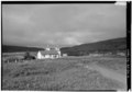 | 5,000 × 3,523 (16.8 എം.ബി.) | Fæ | GWToolset: Creating mediafile for Fæ. HABS batch uploads start 24 June 2014 |
പ്രമാണത്തിന്റെ ഉപയോഗം
താഴെ കാണുന്ന താളിൽ ഈ ചിത്രം ഉപയോഗിക്കുന്നു: