
പ്രമാണം:Cambridgeshire outline map with UK.png

ഈ പ്രിവ്യൂവിന്റെ വലിപ്പം: 504 × 600 പിക്സലുകൾ. മറ്റ് റെസലൂഷനുകൾ: 202 × 240 പിക്സലുകൾ | 600 × 714 പിക്സലുകൾ.
പൂർണ്ണ വലിപ്പം (600 × 714 പിക്സൽ, പ്രമാണത്തിന്റെ വലിപ്പം: 342 കെ.ബി., മൈം തരം: image/png)
| ഈ പ്രമാണം വിക്കിമീഡിയ കോമൺസിൽ നിന്നുള്ളതാണ്. പ്രമാണത്തെക്കുറിച്ചുള്ള വിവരണം താഴെ കൊടുത്തിരിക്കുന്നു.
|
ചുരുക്കം
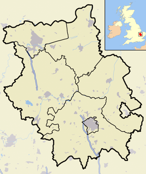
| വിവരണം | A map of the ceremonial county of Cambridgeshire, in the East of England. Appended to the top right is a mini map of the British Isles with Cambridgeshire's location and relative size marked in red. On the main map rural areas are in yellow; urban areas are in grey; district and county boundaries are in black; bodies of water are in light blue; motorways are in dark blue with a white stripe. |
| തീയതി | |
| സ്രോതസ്സ് | Completely self-made, but boundaries and features can be verified via a variety of sources including (but not exclusive to) the Fifth periodical report - Volume 3 Mapping for the London Boroughs and the Metropolitan Counties by the Boundary Commission for England. |
| സ്രഷ്ടാവ് | Jhamez84 |
| അനുമതി (ഈ പ്രമാണത്തിന്റെ പുനരുപയോഗം) |
സ്വന്തം സൃഷ്ടി |
| മറ്റു പതിപ്പുകൾ |
ഈ പ്രമാണത്തിൽ നിന്നും സൃഷ്ടിച്ചവ: |
അനുമതി
| ഈ സൃഷ്ടിയുടെ പകർപ്പവകാശ ഉടമയായ ഞാൻ, ഈ സൃഷ്ടി പൊതുസഞ്ചയത്തിൽ പ്രസിദ്ധീകരിച്ചിരിക്കുന്നു. ഇത് ആഗോള തലത്തിൽ ബാധകമാണ്. ചില രാജ്യങ്ങളിൽ ഇത് നിയമപ്രകാരം സാദ്ധ്യമല്ലെന്ന് വന്നേക്കാം; അങ്ങനെയെങ്കിൽ: ഈ സൃഷ്ടി, നിയമപ്രകാരം നിബന്ധനകൾ ഉണ്ടെങ്കിൽ അവയൊഴിച്ച്, യാതൊരു നിബന്ധനകളും ഇല്ലാതെ ഏതൊരാൾക്കും ഏതൊരു ഉപയോഗത്തിനും, ഉപയോഗപ്പെടുത്തുവാൻ ഞാൻ അനുവദിച്ചിരിക്കുന്നു. |
പ്രമാണ നാൾവഴി
ഏതെങ്കിലും തീയതി/സമയ കണ്ണിയിൽ ഞെക്കിയാൽ പ്രസ്തുതസമയത്ത് ഈ പ്രമാണം എങ്ങനെയായിരുന്നു എന്നു കാണാം.
| തീയതി/സമയം | ലഘുചിത്രം | അളവുകൾ | ഉപയോക്താവ് | അഭിപ്രായം | |
|---|---|---|---|---|---|
| നിലവിലുള്ളത് | 00:01, 23 നവംബർ 2007 | | 600 × 714 (342 കെ.ബി.) | Jza84 | {{Information |Description=Map of the County of Cambridgeshire, England, United Kingdom |Source=self-made |Date=November 2007 |Author= Jhamez84 |Permission=See below |other_versions= }} |
പ്രമാണത്തിന്റെ ഉപയോഗം
താഴെ കാണുന്ന താളിൽ ഈ ചിത്രം ഉപയോഗിക്കുന്നു:
പ്രമാണത്തിന്റെ ആഗോള ഉപയോഗം
താഴെ കൊടുത്തിരിക്കുന്ന മറ്റ് വിക്കികൾ ഈ പ്രമാണം ഉപയോഗിക്കുന്നു:
- ar.wikipedia.org സംരംഭത്തിലെ ഉപയോഗം
- arz.wikipedia.org സംരംഭത്തിലെ ഉപയോഗം
- ceb.wikipedia.org സംരംഭത്തിലെ ഉപയോഗം
- en.wikipedia.org സംരംഭത്തിലെ ഉപയോഗം
- fr.wikipedia.org സംരംഭത്തിലെ ഉപയോഗം
- ro.wikipedia.org സംരംഭത്തിലെ ഉപയോഗം
- sv.wikipedia.org സംരംഭത്തിലെ ഉപയോഗം
- www.wikidata.org സംരംഭത്തിലെ ഉപയോഗം