
പ്രമാണം:Amazon-river-NASA.jpg

ഈ പ്രിവ്യൂവിന്റെ വലിപ്പം: 600 × 600 പിക്സലുകൾ. മറ്റ് റെസലൂഷനുകൾ: 240 × 240 പിക്സലുകൾ | 480 × 480 പിക്സലുകൾ | 768 × 768 പിക്സലുകൾ | 1,024 × 1,024 പിക്സലുകൾ | 2,048 × 2,048 പിക്സലുകൾ | 4,096 × 4,096 പിക്സലുകൾ.
പൂർണ്ണ വലിപ്പം (4,096 × 4,096 പിക്സൽ, പ്രമാണത്തിന്റെ വലിപ്പം: 2.79 എം.ബി., മൈം തരം: image/jpeg)
| ഈ പ്രമാണം വിക്കിമീഡിയ കോമൺസിൽ നിന്നുള്ളതാണ്. പ്രമാണത്തെക്കുറിച്ചുള്ള വിവരണം താഴെ കൊടുത്തിരിക്കുന്നു.
|
ചുരുക്കം
| വിവരണം |
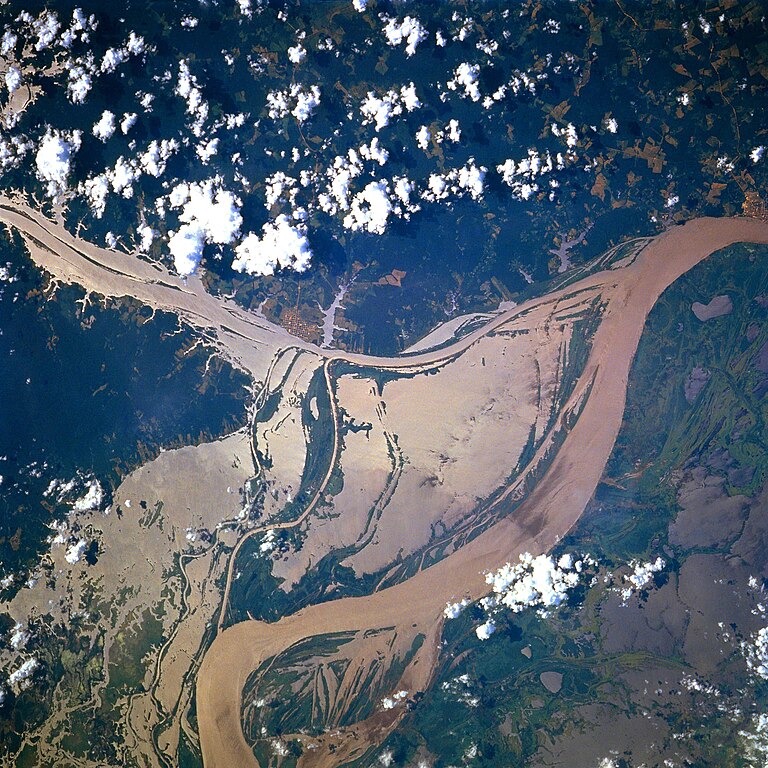
Afrikaans: STS078-751-094 Oorstroomde Amasonerivieroewers in westelike Pará-provinsie, Brasilië in Junie 1996. Die ligging is sowat halfpad tussen Manaus en die Amasonerivierdelta.
Hierdie beeld toon oorstroomde oewers van 'n klein segment van die Amasonerivier, insluitend die oerwouddorpies Oriximiná en Óbidos. Songlans op die modderige rivierwater fasiliteer die onderskeiding van land en water. Deur hierdie beeld met 'n gedetailleerde gebiedskaart te vergelyk, word dit duidelik dat die Amazonerivier sy oewers in die laagliggende dele aanliggend aan die vloedvlakte van die hoofkanaal oorstroom, en groot dele suid van die hoofkanaal staan ook onder (skoon) water. Ontbosde gebiede is binne die digbegroeide terrein aan die noordekant van die Amasonerivier waarneembaar. Die hoofkanaal van die Trombetasrivier kan suidooswaarts nagespeur word, van die linkerrand van die prent af, totdat die Trombetas tussen die oerwouddorpies Oriximiná en Óbidos met die Amasone saamvloei. English: A satellite image of a part of the Amazon River.
Esperanto: La bildo estas kopiita de wikipedia:en. La originala priskribo estas
English: Original caption: [altered to reflect rotation]
|
| തീയതി | |
| സ്രോതസ്സ് | http://earth.jsc.nasa.gov/sseop/EFS/photoinfo.pl?PHOTO=STS078-751-94 (file) |
| സ്രഷ്ടാവ് | NASA |
| വസ്തുവിന്റെ സ്ഥാനം | | സ്ഥാനമനുസരിച്ച് ഇതും മറ്റു ചിത്രങ്ങളും: ഓപ്പൺസ്ട്രീറ്റ്മാപ്പ് |
|---|
ഈ ചിത്രം അല്ലെങ്കിൽ ചലച്ചിത്രം അമേരിക്കൻ ഐക്യനാടുകളിലെ നാസയുടെ (NASA) ഒരു കേന്ദ്രത്തിൽ നിന്ന് പ്രസിദ്ധീകരിച്ചതാണ്, ഫോട്ടോ ഐ.ഡി.: STS078-751-94. ഈ റ്റാഗ് ഇത് ഉൾപ്പെടുത്തിയിരിക്കുന്ന സൃഷ്ടിയുടെ പകർപ്പവകാശസ്ഥിതിയെ സൂചിപ്പിക്കുന്നില്ല. ഒരു സാധാരണ പകർപ്പവകാശ റ്റാഗ് ആവശ്യമാണ്. കോമൺസ്:അനുമതി നൽകൽ കാണുക. മറ്റു ഭാഷകൾ:
|
അനുമതി
| ഈ പ്രമാണം നാസ സൃഷ്ടിച്ചതായതിനാൽ പൊതുസഞ്ചയത്തിൽ വരുന്നു. "നാസ നൽകുന്ന വിവരങ്ങൾ മറ്റുവിധത്തിൽ കുറിച്ചിട്ടില്ലെങ്കിൽ പൊതുസഞ്ചയത്തിൽ വരുന്നു എന്നാണ് നാസയുടെ പകർപ്പവകാശ നയം വ്യക്തമാക്കുന്നത്". (Template:PD-USGov, നാസ പകർപ്പവകാശ നയം താൾ ഒപ്പം JPL ചിത്ര ഉപയോഗ നയം എന്നിവ കാണുക.) | ||
 |
മുന്നറിയിപ്പുകൾ:
|
Old file history
Transferred from English-Wikipedia:
| date/time | username | edit summary |
|---|---|---|
| 02:26, 6 January 2005 | en:User:Quadell | (tagged) |
| 18:08, 18 June 2004 | en:User:Sverdrup | (Image info) |
| 18:06, 18 June 2004 | en:User:Sverdrup | (A satellite image of a part of the <a href="/wiki/Amazon_River" title="Amazon River">Amazon River</a>) |
| Annotations | This image is annotated: View the annotations at Commons |
പ്രമാണ നാൾവഴി
ഏതെങ്കിലും തീയതി/സമയ കണ്ണിയിൽ ഞെക്കിയാൽ പ്രസ്തുതസമയത്ത് ഈ പ്രമാണം എങ്ങനെയായിരുന്നു എന്നു കാണാം.
| തീയതി/സമയം | ലഘുചിത്രം | അളവുകൾ | ഉപയോക്താവ് | അഭിപ്രായം | |
|---|---|---|---|---|---|
| നിലവിലുള്ളത് | 17:13, 8 ഡിസംബർ 2022 | | 4,096 × 4,096 (2.79 എം.ബി.) | JMK | boost saturation, add some contrast |
| 17:10, 8 ഡിസംബർ 2022 |  | 4,096 × 4,096 (2.69 എം.ബി.) | JMK | rotate 180, north up | |
| 10:10, 10 നവംബർ 2022 |  | 4,096 × 4,096 (15.22 എം.ബി.) | Askeuhd | Higher resolution version | |
| 14:15, 10 ഒക്ടോബർ 2012 |  | 640 × 640 (418 കെ.ബി.) | Rotatebot | Bot: Image rotated by 180° | |
| 14:39, 29 ജനുവരി 2006 |  | 640 × 640 (377 കെ.ബി.) | Maksim | La bildo estas kopiita de wikipedia:en. La originala priskribo estas: A satellite image of a part of the Amazon River. {{PD-USGov-NASA}} '''Original caption:''' :''STS078-751-094 Amazon River, Western Para Province, Brazil June 1996'' :''This image s |
പ്രമാണത്തിന്റെ ഉപയോഗം
താഴെ കാണുന്ന താളിൽ ഈ ചിത്രം ഉപയോഗിക്കുന്നു:
പ്രമാണത്തിന്റെ ആഗോള ഉപയോഗം
താഴെ കൊടുത്തിരിക്കുന്ന മറ്റ് വിക്കികൾ ഈ പ്രമാണം ഉപയോഗിക്കുന്നു:
- ar.wikipedia.org സംരംഭത്തിലെ ഉപയോഗം
- ast.wikipedia.org സംരംഭത്തിലെ ഉപയോഗം
- azb.wikipedia.org സംരംഭത്തിലെ ഉപയോഗം
- ca.wikipedia.org സംരംഭത്തിലെ ഉപയോഗം
- ce.wikipedia.org സംരംഭത്തിലെ ഉപയോഗം
- cv.wikipedia.org സംരംഭത്തിലെ ഉപയോഗം
- en.wikipedia.org സംരംഭത്തിലെ ഉപയോഗം
- eo.wikipedia.org സംരംഭത്തിലെ ഉപയോഗം
- es.wikipedia.org സംരംഭത്തിലെ ഉപയോഗം
- eu.wikipedia.org സംരംഭത്തിലെ ഉപയോഗം
- fa.wikipedia.org സംരംഭത്തിലെ ഉപയോഗം
- fr.wikipedia.org സംരംഭത്തിലെ ഉപയോഗം
- fy.wikipedia.org സംരംഭത്തിലെ ഉപയോഗം
- id.wikipedia.org സംരംഭത്തിലെ ഉപയോഗം
- ilo.wikipedia.org സംരംഭത്തിലെ ഉപയോഗം
- kk.wikipedia.org സംരംഭത്തിലെ ഉപയോഗം
- krc.wikipedia.org സംരംഭത്തിലെ ഉപയോഗം
- mr.wikipedia.org സംരംഭത്തിലെ ഉപയോഗം
- nl.wikipedia.org സംരംഭത്തിലെ ഉപയോഗം
- no.wikipedia.org സംരംഭത്തിലെ ഉപയോഗം
- os.wikipedia.org സംരംഭത്തിലെ ഉപയോഗം
- pl.wiktionary.org സംരംഭത്തിലെ ഉപയോഗം
- pt.wikipedia.org സംരംഭത്തിലെ ഉപയോഗം
- rm.wikipedia.org സംരംഭത്തിലെ ഉപയോഗം
- ru.wikipedia.org സംരംഭത്തിലെ ഉപയോഗം
- uk.wikipedia.org സംരംഭത്തിലെ ഉപയോഗം
- vec.wikipedia.org സംരംഭത്തിലെ ഉപയോഗം
- vi.wikipedia.org സംരംഭത്തിലെ ഉപയോഗം
- www.wikidata.org സംരംഭത്തിലെ ഉപയോഗം
- zh-yue.wikipedia.org സംരംഭത്തിലെ ഉപയോഗം
- zh.wikipedia.org സംരംഭത്തിലെ ഉപയോഗം