"ജയ്പൂർ ജില്ല" എന്ന താളിന്റെ പതിപ്പുകൾ തമ്മിലുള്ള വ്യത്യാസം
Content deleted Content added
Rescuing 1 sources and tagging 0 as dead.) #IABot (v2.0.8 |
Rescuing 1 sources and tagging 0 as dead.) #IABot (v2.0.8 |
||
| വരി 16: | വരി 16: | ||
|SexRatio = |
|SexRatio = |
||
|Collector = |
|Collector = |
||
|Tehsils = <ref name="Jaipur Parliamentary Constituency" >{{cite web | url = http://164.100.9.199/ecimaps/ECIPDF/State_pc_Map/RAJASTHAN.pdf | title = Parliamentary Constituencies of Rajasthan | accessdate = 28-Feb-2012 | year = 2012 | publisher = 164.100.9.199/home.html}}</ref> |
|Tehsils = <ref name="Jaipur Parliamentary Constituency" >{{cite web | url = http://164.100.9.199/ecimaps/ECIPDF/State_pc_Map/RAJASTHAN.pdf | title = Parliamentary Constituencies of Rajasthan | accessdate = 28-Feb-2012 | year = 2012 | publisher = 164.100.9.199/home.html | archive-date = 2013-06-16 | archive-url = https://web.archive.org/web/20130616220354/http://164.100.9.199/ecimaps/ECIPDF/State_pc_Map/RAJASTHAN.pdf | url-status = dead }}</ref> |
||
|Assembly = <ref name="Jaipur district Assembly Constituencies" >{{cite web | url = http://gisserver1.nic.in/ecimaps/ECIPDF%5CRaj_Maps%5Cac_jaipur.pdf | title = Assembly Constituencies of Jaipur district | accessdate = 28-Feb-2012-02-23 | year = 2012 | publisher = gisserver1.nic.in/ | archive-date = 2013-12-21 | archive-url = https://web.archive.org/web/20131221235824/http://gisserver1.nic.in/ecimaps/ECIPDF%5CRaj_Maps%5Cac_jaipur.pdf | url-status = dead }}</ref> |
|Assembly = <ref name="Jaipur district Assembly Constituencies" >{{cite web | url = http://gisserver1.nic.in/ecimaps/ECIPDF%5CRaj_Maps%5Cac_jaipur.pdf | title = Assembly Constituencies of Jaipur district | accessdate = 28-Feb-2012-02-23 | year = 2012 | publisher = gisserver1.nic.in/ | archive-date = 2013-12-21 | archive-url = https://web.archive.org/web/20131221235824/http://gisserver1.nic.in/ecimaps/ECIPDF%5CRaj_Maps%5Cac_jaipur.pdf | url-status = dead }}</ref> |
||
|Highways = National Highway 11 (NH-11), National Highway 8 (NH-8) |
|Highways = National Highway 11 (NH-11), National Highway 8 (NH-8) |
||
20:10, 29 ഓഗസ്റ്റ് 2021-നു നിലവിലുണ്ടായിരുന്ന രൂപം
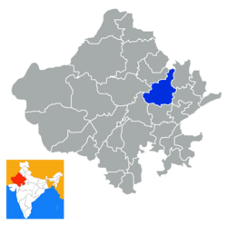
Jaipur ജില്ല Jaipur District | |
|---|---|
 Jaipur ജില്ല (Rajasthan) | |
| രാജ്യം | ഇന്ത്യ |
| സംസ്ഥാനം | Rajasthan |
| ഭരണനിർവ്വഹണ പ്രദേശം | Jaipur Division |
| ആസ്ഥാനം | Jaipur |
| താലൂക്കുകൾ | [1] |
| • നിയമസഭാ മണ്ഡലങ്ങൾ | [2] |
(2011) | |
| • ആകെ | 6,663,971ഉദ്ധരിച്ചതിൽ പിഴവ്: അസാധുവായ <ref> ടാഗ്;
അസാധുവായ പേരുകൾ, ഉദാ: too many |
| പ്രധാന പാതകൾ | National Highway 11 (NH-11), National Highway 8 (NH-8) |
| നിർദ്ദേശാങ്കം | 26°55′34″N 75°49′25″E / 26.926°N 75.8235°E |
| ശരാശരി വാർഷിക പാതം | 459.8 mm |
| വെബ്സൈറ്റ് | ഔദ്യോഗിക വെബ്സൈറ്റ് |

ജയ്പൂർ ജില്ല:വടക്കേ ഇന്ത്യൻ സംസ്ഥാനമായ രാജസ്ഥാനിലെ ഒരു ജില്ലയാണ് ജയ്പൂർ ജില്ല.രാജസ്ഥാൻ സംസ്ഥാനത്തിന്റെ തലസ്ഥാനവും സംസ്ഥാനത്തിലെ ഏറ്റവും വലിയ പട്ടനവുമായ ജയ്പൂർ പട്ടണം ഈ ജില്ലാ ആസ്ഥാനം കൂടിയാണ്. ജയ്പൂർ ജില്ല വിസ്തീർണം 11,152 ചതുരശ്ര കിലോ മീറ്റർ,ജനസംഖ്യ :5,252,388 ,ജനസാന്ദ്രത;471 ആളുകൾ /ചതുരശ്ര കിലോമീറ്റർ.ഈ ജില്ലയുടെ വടക്ക് ഭാഗത്തായി സികർ ജില്ലയും വടക്ക് കിഴക്കായി ഹരിയാന സംസ്ഥാനവും കിഴക്ക് ഭാഗം അൽവാർ ,ദുസ ജില്ലകളും തെക്ക്കിഴക്കായി സവായീ മാധേപൂർ ജില്ലയും തെക്ക് ടോങ്ക് ജില്ലയും പടിഞ്ഞാറു അജ്മീർ ജില്ലയും വടക്ക് പടിഞ്ഞരായീ നാഗൂർ ജില്ലയും സ്ഥിതി ചെയ്യുന്നു.
അവലംബം
- ↑ "Parliamentary Constituencies of Rajasthan" (PDF). 164.100.9.199/home.html. 2012. Archived from the original (PDF) on 2013-06-16. Retrieved 28-Feb-2012.
{{cite web}}: Check date values in:|accessdate=(help) - ↑ "Assembly Constituencies of Jaipur district" (PDF). gisserver1.nic.in/. 2012. Archived from the original (PDF) on 2013-12-21. Retrieved 28-Feb-2012-02-23.
{{cite web}}: Check date values in:|accessdate=(help)
