
"ജമ്മു-കശ്മീർ" എന്ന താളിന്റെ പതിപ്പുകൾ തമ്മിലുള്ള വ്യത്യാസം
(ചെ.) →ചരിത്രം |
No edit summary റ്റാഗുകൾ: കണ്ടുതിരുത്തൽ സൗകര്യം മൊബൈൽ സൈറ്റ് മൊബൈൽ വെബിലെ തിരുത്ത് |
||
| വരി 3: | വരി 3: | ||
{{prettyurl|Jammu and Kashmir}} |
{{prettyurl|Jammu and Kashmir}} |
||
{{Infobox settlement |
{{Infobox settlement |
||
<!-- See Template:Infobox settlement for additional fields and descriptions --> |
<!-- See Template:Infobox settlement for additional fields and descriptions -->| name = ജമ്മു-കശ്മീർ |
||
| ⚫ | |||
| name = ജമ്മു-കശ്മീർ |
|||
| ⚫ | |||
| ⚫ | |||
| ⚫ | |||
| ⚫ | |||
| ⚫ | |||
| ⚫ | |||
| ⚫ | |||
| ⚫ | |||
| ⚫ | |||
| ⚫ | |||
| image_flag = |
|||
| ⚫ | |||
| ⚫ | |||
| image_flag = Jammu-Kashmir-flag.svg |
|||
| ⚫ | |||
| ⚫ | |||
| ⚫ | |||
| ⚫ | |||
| map_alt = |
|||
| ⚫ | |||
| ⚫ | |||
| map_alt = |
|||
| ⚫ | |||
| ⚫ | |||
| ⚫ | |||
| ⚫ | |||
| ⚫ | |||
| ⚫ | |||
| ⚫ | |||
| ⚫ | |||
| ⚫ | |||
| ⚫ | |||
| ⚫ | |||
| ⚫ | |||
| ⚫ | |||
| ⚫ | |||
| ⚫ | |||
| ⚫ | |||
| ⚫ | |||
| ⚫ | |||
| ⚫ | |||
| ⚫ | |||
| ⚫ | |||
| ⚫ | |||
| ⚫ | |||
| ⚫ | |||
| ⚫ | |||
| ⚫ | |||
| ⚫ | |||
| ⚫ | |||
| ⚫ | |||
| ⚫ | |||
| p1 = 22 |
|||
| ⚫ | |||
| ⚫ | |||
| p1 = 22 |
|||
| ⚫ | |||
| ⚫ | |||
| seat = |
|||
| ⚫ | |||
* [[ശ്രീനഗർ]] (വേനൽക്കാലം) |
* [[ശ്രീനഗർ]] (വേനൽക്കാലം) |
||
| seat1_type |
| seat1_type = Largest city |
||
| seat1 |
| seat1 = ശ്രീനഗർ |
||
| government_footnotes |
| government_footnotes = {{ref|leg|[*]}} |
||
| leader_title |
| leader_title = [[Governors of Jammu and Kashmir|Governor]] |
||
| leader_name |
| leader_name = [[നരീന്ദർ നാഥ് വോറ]] |
||
| leader_title1 |
| leader_title1 = [[List of Prime and Chief Ministers of Jammu and Kashmir|Chief Minister]] |
||
| leader_name1 |
| leader_name1 = [[മെഹബൂബ മുഫ്തി]]<small>(നിർദ്ദേശിക്കപ്പെട്ടിരിക്കുന്നു)</small>, ([[പീപ്പിൾസ് ഡെമോക്രാറ്റിക് പാർട്ടി (ജമ്മു കശ്മീർ)|പി.ഡി.പി]]) |
||
| leader_title2 |
| leader_title2 = [[Jammu and Kashmir Legislature|Legislature]] |
||
| leader_name2 |
| leader_name2 = [[Bicameralism|Bicameral]] (89 + 36 seats) |
||
| unit_pref |
| unit_pref = Metric |
||
| area_footnotes |
| area_footnotes = |
||
| area_total_km2 |
| area_total_km2 = 222236 |
||
| area_note |
| area_note = |
||
| area_rank |
| area_rank = [[List of states and territories of India by area|6th]] |
||
| elevation_footnotes |
| elevation_footnotes = |
||
| elevation_m |
| elevation_m = 327 |
||
| population_footnotes |
| population_footnotes = |
||
| population_total |
| population_total = 12548926 |
||
| population_as_of |
| population_as_of = 2011 |
||
| population_rank |
| population_rank = [[List of states and union territories of India by population|18th]] |
||
| population_density_km2 |
| population_density_km2 = 56 |
||
| population_note |
| population_note = |
||
| timezone1 |
| timezone1 = [[Indian Standard Time|IST]] |
||
| utc_offset1 |
| utc_offset1 = +05:30 |
||
| iso_code |
| iso_code = [[ISO 3166-2:IN|IN-JK]] |
||
| unemployment_rate = |
|||
| blank_name_sec1 |
| blank_name_sec1 = [[Human Development Index|HDI]] |
||
| blank_info_sec1 |
| blank_info_sec1 = {{increase}} 0.601 (<span style="color:#fc0">medium</span>) |
||
| blank1_name_sec1 |
| blank1_name_sec1 = HDI rank |
||
| blank1_info_sec1 |
| blank1_info_sec1 = 17th (2005) |
||
| blank_name_sec2 |
| blank_name_sec2 = [[Literacy in India|Literacy]] |
||
| blank_info_sec2 |
| blank_info_sec2 = 66.7% (21st) |
||
| blank1_name_sec2 |
| blank1_name_sec2 = Official language |
||
| blank1_info_sec2 |
| blank1_info_sec2 = [[കശ്മീരി ഭാഷ|കശ്മീരി]], [[ഉർദു]] |
||
| blank2_name_sec2 |
| blank2_name_sec2 = Other languages |
||
| blank2_info_sec2 |
| blank2_info_sec2 = [[Dogri language|ദോഗ്രി]], [[ഹിന്ദി]], [[Indian English|ഇംഗ്ലീഷ്]], [[Ladakhi language|ലഡാക്കി]] |
||
| website |
| website = {{URL|www.jammukashmir.nic.in}} |
||
| footnotes |
| footnotes = |
||
}} |
}} |
||
06:54, 5 ഓഗസ്റ്റ് 2019-നു നിലവിലുണ്ടായിരുന്ന രൂപം
ജമ്മു-കശ്മീർ जोम त कशीर جوم تِ کشیر | ||
|---|---|---|
| ||
 ജമ്മു-കശ്മീരിന്റെ ഭൂപടം | ||
| Country | ||
| Established | 26 October 1947 | |
| Capital | ||
| Largest city | ശ്രീനഗർ | |
| Districts | 22 | |
| • Governor | നരീന്ദർ നാഥ് വോറ | |
| • Chief Minister | മെഹബൂബ മുഫ്തി(നിർദ്ദേശിക്കപ്പെട്ടിരിക്കുന്നു), (പി.ഡി.പി) | |
| • Legislature | Bicameral (89 + 36 seats) | |
| • ആകെ | 2,22,236 ച.കി.മീ.(85,806 ച മൈ) | |
| •റാങ്ക് | 6th | |
| ഉയരം | 327 മീ(1,073 അടി) | |
(2011) | ||
| • ആകെ | 1,25,48,926 | |
| • റാങ്ക് | 18th | |
| • ജനസാന്ദ്രത | 56/ച.കി.മീ.(150/ച മൈ) | |
| സമയമേഖല | UTC+05:30 (IST) | |
| ISO കോഡ് | IN-JK | |
| HDI | ||
| HDI rank | 17th (2005) | |
| Literacy | 66.7% (21st) | |
| Official language | കശ്മീരി, ഉർദു | |
| Other languages | ദോഗ്രി, ഹിന്ദി, ഇംഗ്ലീഷ്, ലഡാക്കി | |
| വെബ്സൈറ്റ് | www | |

ജമ്മു-കശ്മീർ (ദോഗ്രി: जम्मू और कश्मीर; ഉറുദു: مقبوضہ کشمیر) ) ഇന്ത്യയുടെ വടക്കേ അതിർത്തി സംസ്ഥാനമാണ്. ഹിമാലയൻ പർവതനിരകളിലും താഴ്വാരങ്ങളിലുമായി വ്യാപിച്ചുകിടക്കുന്ന സംസ്ഥാനമാണിത്. തെക്ക് ഹിമാചൽ പ്രദേശ്, പടിഞ്ഞാറ് പാകിസ്താൻ, വടക്കും കിഴക്കും ചൈന എന്നിവയാണ് ജമ്മു-കാശ്മീരിന്റെ അതിർത്തികൾ. ജമ്മു, കശ്മീർ, ലഡാക് എന്നിങ്ങനെ മൂന്നു പ്രദേശങ്ങളുടെ സഞ്ചയമാണീ സംസ്ഥാനം. വേനൽക്കാലത്ത് ശ്രീനഗറും മഞ്ഞുകാലത്ത് ജമ്മുവുമാണ് തലസ്ഥാനം. മനോഹരങ്ങളായ തടാകങ്ങളും മഞ്ഞു മലകളും പച്ചതാഴ്വാരങ്ങളും നിറഞ്ഞ ഈ പ്രദേശം ഇന്ത്യയിലെ ഏറ്റവും പ്രകൃതിരമണീയമായ സംസ്ഥാനങ്ങളിലൊന്നാണ്[1].
ഇന്ത്യ സ്വതന്ത്രമായതിനുശേഷം ഏറ്റവുമേറെ വിവാദങ്ങളുണ്ടാക്കിയ ഭൂപ്രദേശമാണിത്. ഇന്ത്യ, പാകിസ്താൻ, ചൈന എന്നീ മൂന്നു രാജ്യങ്ങളുൾപ്പെടുന്ന തർക്കപ്രദേശമെന്ന നിലയിലും ഇതിന്റെ ഫലമായുള്ള സംഘർഷങ്ങളുടെ പേരിലും രാജ്യാന്തര ശ്രദ്ധയാകർഷിക്കുന്നു. ജമ്മു-കാശ്മീരിനെ ഇന്ത്യ അതിന്റെ അവിഭാജ്യ ഘടകമായി കരുതുന്നു. എന്നാൽ ഈ ഭൂപ്രദേശത്തിന്റെ പകുതിയോളമേ ഇന്ത്യയുടെ നേരിട്ടുള്ള നിയന്ത്രണത്തിലുള്ളൂ. ഭരണഘടനയുടെ 370ആം അനുച്ഛേദപ്രകാരം ഇന്ത്യയിൽ പ്രത്യേക പരിഗണനകളുള്ള സംസ്ഥാനമാണിത്. എന്നാൽ ജമ്മു-കാശ്മീരിന്റെ മേലുള്ള ഇന്ത്യയുടെ അവകാശവാദത്തെ അയൽ രാജ്യങ്ങളായ പാകിസ്താനും ചൈനയും വർഷങ്ങളായി എതിർക്കുന്നു. വടക്കു പടിഞ്ഞാറുള്ള പ്രദേശങ്ങൾ പാകിസ്താന്റെ നിയന്ത്രണത്തിലുമാണ്. ഇന്ത്യ ഈ പ്രദേശത്തെ പാക്ക് അധിനിവേശ കശ്മീർ എന്നു വിശേഷിപ്പിക്കുന്നു. കിഴക്കുഭാഗത്തുള്ള അക്സായി ചിൻ പ്രദേശം ചൈനയുടെ നിയന്ത്രണത്തിലുമാണ്. ഇവയ്ക്കൊക്കെ പുറമേ സ്വതന്ത്ര കാശ്മീരിനായി പോരാടുന്ന തീവ്രവാദ സംഘങ്ങളും ഇവിടെ സജീവമാണ്. ചുരുക്കത്തിൽ അതിർത്തി തർക്കങ്ങളും വിഘടനവാദ പ്രവർത്തനങ്ങളും സൈനിക കടന്ന് കയറ്റങ്ങളും മൂലം ഇന്ത്യയിലെ ഏറ്റവും അരക്ഷിതമായ പ്രദേശമായി മാറിയിട്ടുണ്ട് ഈ സംസ്ഥാനം.
ചരിത്രം
ഇന്ത്യ-പാകിസ്താൻ വിഭജനകാലത്ത് സ്വതന്ത്രമായി നിന്ന പ്രദേശം ആണ് കാശ്മീർ. പിന്നാലെ പാകിസ്താൻ അവരുടെ കൂടെ ചേർക്കുന്നതിന് കാശ്മീരിൽ സൈനിക മുന്നേറ്റം നടത്തി മൂന്നിലൊന്ന് പ്രദേശം കൈവശപ്പെടുത്തി. അപ്പോൾ കശ്മീർ മഹാരാജാവ് ഇന്ത്യയുടെ സഹായം തേടുകയും ഇന്ത്യയിൽ ലയിക്കാൻ സമ്മതിക്കുകയും ചെയ്തു. അപ്പോൾ മാത്രം ആണ് ഇന്തൃൻ സൈനൃം കാശ്മീരിൽ പ്രവേശിച്ച് പാകിസ്താനുമായി യുദ്ധം ചെയ്തതും. പക്ഷെ പാകിസ്താൻ പിടിച്ചെടുത്ത പ്രദേശം തിരിച്ചു പിടിക്കാൻ ഇന്ത്യക്ക് പറ്റിയില്ല . ഇത് പാക് അധിനിവേശ കാശ്മീർ എന്നറിയപ്പെട്ടു. പാകിസ്താൻ ഗവൺമെന്റ് ഇതിന്റെ സ്വയംഭരണാവകാശം ഉണ്ട് എന്ന് പ്രഖ്യപിച്ചു കൊണ്ട് ഇന്ത്യയുമായി 1947,1965 യുദ്ധം ചെയ്യുകയുണ്ടായി. രണ്ടു യുദ്ധത്തിലും പാകിസ്താൻ പരാജിതരായി. (പക്ഷെ പോയത് പോയി). ഇതിനെ തുടർന്ന് പാകിസ്താനിനെ തീവ്രവാദികൾ ഭൂരിഭാഗ ജനവിഭാഗമായ കാശ്മീരിലെ മുസ്ലീം ജനതയെ മതവികാരത്തിന്റെ പേരിൽ ഇളക്കിവിടുകയും തീവ്രവാദി സംഘടകൾ ഉണ്ടാക്കുകയും, കാശ്മീരിലെ ജനജീവിതം ദുസ്സഹകമാക്കുകയും കുട്ടകൊലകൾ നടത്തുകയും ചെയ്തു. 1985 സിയാച്ചിനിൽ നുഴഞ്ഞുകയറ്റം നടത്തിയ പാകിസ്താൻ സേനക്കെതിരെ ഇന്ത്യ ശക്തമായി പ്രതിരോധിക്കുകയും ഒരു യൂദ്ധത്തിന്റെ വക്കിൽ എത്തുകയും ചെയ്തു. അതിനുശേഷം 1999ൽ പാകിസ്താൻ സൈന്യം വീണ്ടും കാർഗിലിൽ നുഴഞ്ഞു കയറുകയും ഇന്ത്യയുമായി യുദ്ധത്തിൽ എത്തുകയും ചെയ്റ്റു. യുദ്ധാവസാനം പാകിസ്താൻ സേനയെ തുരത്തി ഓടിക്കുകയും കാർഗിൽ കീഴടക്കുകയും ചെയ്തു
-
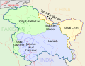 ജമ്മു-കശ്മീർ - ഭൂപടം
 -
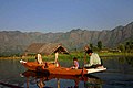 ശ്രീനഗറിലെ ദാൽ തടാകം

പ്രത്യേക പദവി
ഇന്ത്യൻ യൂണിയനിൽ പ്രത്യേക പദവിയുള്ള ഒരേയൊരു സംസ്ഥാനമാണിത്. ഇന്ത്യൻ ഭരണഘടനയുടെ 370-ആം വകുപ്പനുസരിച്ച് പ്രതിരോധം, വാർത്താവിനിമയം, വിദേശകാര്യം എന്നീ മേഖലകളിലൊഴികെ ഇന്ത്യൻ പാർലമെന്റ് പാസ്സാക്കുന്ന നിയമങ്ങൾ ജമ്മു-കശ്മീരിന് ബാധകമാകണമെങ്കിൽ സംസ്ഥാന സർക്കാരിന്റെ അംഗീകാരം ആവശ്യമാണ്. സ്വന്തമായി ഭരണഘടനയും പതാകയുമുള്ള ഒരേയൊരു ഇന്ത്യൻ സംസ്ഥാനമാണിത്.
അവലംബം
- ↑ "സോനാമാർഗിലെ പ്രഭാതം" (PDF). മലയാളം വാരിക. 2012 ഒക്റ്റോബർ 12. Retrieved 2013 ഫെബ്രുവരി 11.
{{cite news}}: Check date values in:|accessdate=and|date=(help)

|
| |||
ഇതും കാണുക
|
ജമ്മു-കശ്മീരിന്റെ ഭൂമിശാസ്ത്രവുമായി ബന്ധപ്പെട്ട ഈ ലേഖനം അപൂർണ്ണമാണ്. ഇതു വികസിപ്പിക്കുവാൻ സഹായിക്കുക. |