"ജാൽസൂർ" എന്ന താളിന്റെ പതിപ്പുകൾ തമ്മിലുള്ള വ്യത്യാസം
Content deleted Content added
'കർണാടകത്തിലെ ഒരു നഗരം ആണ് '''ജാൽസൂർ'''.' താൾ സൃഷ്ടിച്ചിരിക്കുന്നു റ്റാഗുകൾ: മൊബൈൽ സൈറ്റ് മൊബൈൽ വെബിലെ തിരുത്ത് |
No edit summary |
||
| വരി 1: | വരി 1: | ||
{{Infobox settlement |
|||
| name = Jalsoor |
|||
| native_name = |
|||
| native_name_lang = |
|||
| other_name = Jalsur |
|||
| nickname = |
|||
| settlement_type = village |
|||
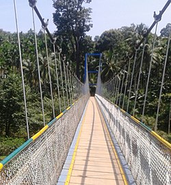
| image_skyline = File:Hanging Bridge, Jalsoor.jpg |
|||
| image_alt = |
|||
| image_caption = Hanging Bridge |
|||
| pushpin_map = |
|||
| pushpin_label_position = right |
|||
| pushpin_map_alt = |
|||
| pushpin_map_caption = Location in Karnataka, India |
|||
| coordinates = {{coord|12.33|N|75.23|E|display=inline,title}} |
|||
| subdivision_type = Country |
|||
| subdivision_name = {{flag|India}} |
|||
| subdivision_type1 = [[States and territories of India|State]] |
|||
| subdivision_name1 = [[Karnataka]] |
|||
| subdivision_type2 = [[List of districts of India|District]] |
|||
| subdivision_name2 = [[Dakshina Kannada]] |
|||
| established_title = <!-- Established --> |
|||
| established_date = |
|||
| founder = |
|||
| named_for = |
|||
| parts_type = [[Taluka]]s |
|||
| parts = Sullia |
|||
| government_type = |
|||
| governing_body = [[Gram panchayat]] |
|||
| unit_pref = Metric |
|||
| area_footnotes = |
|||
| area_rank = |
|||
| area_total_km2 = |
|||
| elevation_footnotes = |
|||
| elevation_m = |
|||
| population_total = 6368 |
|||
| population_as_of = 2001 |
|||
| population_rank = |
|||
| population_density_km2 = auto |
|||
| population_demonym = |
|||
| population_footnotes = |
|||
| demographics_type1 = Languages |
|||
| demographics1_title1 = Official |
|||
| demographics1_info1 = [[Kannada]], [[Tulu language|Tulu]] and [[Arebhashe]] |
|||
| timezone1 = [[Indian Standard Time|IST]] |
|||
| utc_offset1 = +5:30 |
|||
| postal_code_type = [[Postal Index Number|PIN]] |
|||
| postal_code = 574239 |
|||
| area_code_type = Telephone code |
|||
| area_code = 08257 |
|||
| telephone = 288*** |
|||
| registration_plate = KA 21 |
|||
| blank1_name_sec1 = Nearest city |
|||
| blank1_info_sec1 = [[Mangalore]] |
|||
| blank2_name_sec1 = [[Human sex ratio|Sex ratio]] |
|||
| blank2_info_sec1 = 1:1 [[male|♂]]/[[female|♀]] |
|||
| blank3_name_sec1 = Literacy |
|||
| blank3_info_sec1 = 100%% |
|||
| blank4_name_sec1 = [[Lok Sabha]] constituency |
|||
| blank4_info_sec1 = Mangalore |
|||
| blank5_name_sec1 = [[Vidhan Sabha]] constituency |
|||
| blank5_info_sec1 = Sullia |
|||
| blank1_name_sec2 = [[Climate of India|Climate]] |
|||
| blank1_info_sec2 = [[Climatic regions of India|cool]] <small>([[Köppen climate classification|Köppen]])</small> |
|||
| website = |
|||
| iso_code = [[ISO 3166-2:IN|IN-KA]] |
|||
| footnotes = |
|||
}} |
|||
[[കർണാടകം|കർണാടകത്തിലെ]] ഒരു നഗരം ആണ് '''ജാൽസൂർ'''. |
[[കർണാടകം|കർണാടകത്തിലെ]] ഒരു നഗരം ആണ് '''ജാൽസൂർ'''. |
||
==ചിത്രശാല== |
|||
<gallery> |
|||
File:Panchakkal school. Jalsoor.jpg|Panchakkal School |
|||
File:Jalsoor Sullia (2).jpg|Jalsoor Junction |
|||
File:Jalsoor Sullia (1).jpg|Jalsoor Mosque |
|||
</gallery> |
|||
17:00, 27 മാർച്ച് 2019-നു നിലവിലുണ്ടായിരുന്ന രൂപം
Jalsoor Jalsur | |
|---|---|
village | |
 Hanging Bridge | |
| Coordinates: 12°20′N 75°14′E / 12.33°N 75.23°E | |
| Country | |
| State | Karnataka |
| District | Dakshina Kannada |
| Talukas | Sullia |
| • ഭരണസമിതി | Gram panchayat |
(2001) | |
| • ആകെ | 6,368 |
| • Official | Kannada, Tulu and Arebhashe |
| സമയമേഖല | UTC+5:30 (IST) |
| PIN | 574239 |
| Telephone code | 08257 |
| ISO കോഡ് | IN-KA |
| വാഹന റെജിസ്ട്രേഷൻ | KA 21 |
| Nearest city | Mangalore |
| Sex ratio | 1:1 ♂/♀ |
| Literacy | 100%% |
| Lok Sabha constituency | Mangalore |
| Vidhan Sabha constituency | Sullia |
| Climate | cool (Köppen) |
കർണാടകത്തിലെ ഒരു നഗരം ആണ് ജാൽസൂർ.
ചിത്രശാല
-
Panchakkal School
-
Jalsoor Junction
-
Jalsoor Mosque


