"ഫ്രാങ്ക്ഫോർട്ട്, കെൻറുക്കി" എന്ന താളിന്റെ പതിപ്പുകൾ തമ്മിലുള്ള വ്യത്യാസം
Content deleted Content added
''''ഫ്രാങ്ക്ഫോർട്ട് പട്ടണം''' യു.എസ് സംസ്ഥാനമായി...' താൾ സൃഷ്ടിച്ചിരിക്കുന്നു |
(ചെ.)No edit summary |
||
| വരി 1: | വരി 1: | ||
{{Infobox settlement |
|||
|official_name = Frankfort |
|||
|settlement_type = [[list of cities in Kentucky|City]] |
|||
|nickname = |
|||
|motto = |
|||
<!-- Images --> |
|||
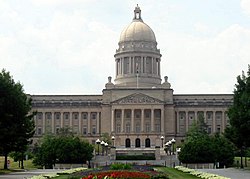
|image_skyline = KY State Capitol.jpg |
|||
|imagesize = 250px |
|||
|image_caption = [[Kentucky State Capitol]] |
|||
|image_flag = |
|||
|image_seal = |
|||
<!-- Maps --> |
|||
|image_map = Franklin County Kentucky incorporated and unincorporated areas Frankfort highlighted.svg |
|||
|mapsize = 300px |
|||
|map_caption = Location in [[Franklin County, Kentucky|Franklin County]] and the state of [[Kentucky]] |
|||
| pushpin_map = USA |
|||
| pushpin_map_caption = Location in the United States |
|||
<!-- Location --> |
|||
|coordinates_region = US-KY |
|||
|subdivision_type = Country |
|||
|subdivision_name = United States |
|||
|subdivision_type1 = [[US state|State]] |
|||
|subdivision_name1 = [[Kentucky]] |
|||
|subdivision_type2 = [[List of counties in Kentucky|County]] |
|||
|subdivision_name2 = [[Franklin County, Kentucky|Franklin]] |
|||
|government_footnotes = |
|||
|government_type = Council/Manager |
|||
|leader_title = [[Mayor]] |
|||
|leader_name = [[William May (American politician)|William May]] |
|||
|leader_title1 = |
|||
|leader_name1 = |
|||
|established_title = Established |
|||
|established_title2 = [[Municipal corporation|Incorporated]] |
|||
|established_date = 1786 |
|||
|established_date2 = February 28, 1835 |
|||
<!-- Area --> |
|||
|unit_pref = Imperial |
|||
|area_footnotes = |
|||
|area_magnitude = |
|||
|area_total_km2 = 37.9<!--37.861053 m2--> |
|||
|area_land_km2 = 37.1<!--37081381 m2--> |
|||
|area_water_km2 = 0.8<!--779672 m2--> |
|||
|area_total_sq_mi = 14.6<!--14.618054 mi2--> |
|||
|area_land_sq_mi = 14.3<!--14.317021 mi2--> |
|||
|area_water_sq_mi = 0.3<!--0.301033 mi2--> |
|||
<!-- Population --> |
|||
|population_as_of = [[2010 United States Census|2010]] |
|||
|population_footnotes = |
|||
|population_total = 25527 |
|||
|population_density_km2 = 674.2 |
|||
|population_density_sq_mi = 1746.3 |
|||
<!-- General information --> |
|||
|timezone = [[Eastern Time Zone|Eastern (EST)]] |
|||
|utc_offset = -5 |
|||
|timezone_DST = EDT |
|||
|utc_offset_DST = -4 |
|||
|elevation_footnotes = |
|||
|elevation_m = |
|||
|elevation_ft = 509 |
|||
|latd = 38 |latm = 12 |latNS = N |
|||
|longd = 84 |longm = 52 |longEW = W |
|||
<!-- Area/postal codes & others --> |
|||
|postal_code_type = [[ZIP Code]] |
|||
|postal_code = 40601-40604, 40618-40622 |
|||
|area_code = [[Area code 502|502]] |
|||
|blank_name = [[Federal Information Processing Standard|FIPS code]] |
|||
|blank_info = 21-28900 |
|||
|blank1_name = [[Geographic Names Information System|GNIS]] feature ID |
|||
|blank1_info = 0517517 |
|||
|website = [http://www.frankfort.ky.gov/ City website] |
|||
|footnotes = |
|||
}} |
|||
'''ഫ്രാങ്ക്ഫോർട്ട് പട്ടണം''' യു.എസ് സംസ്ഥാനമായി കോമൺവെൽത്ത് ഓഫ് കെൻറുക്കിയുടെ തലസ്ഥാനവും ഫ്രാങ്ക്ളിൻ കൌണ്ടിയുടെ കൌണ്ടി സീറ്റുമാണ് <ref name="GR6">{{cite web|url=http://www.naco.org/Counties/Pages/FindACounty.aspx|title=Find a County|publisher=National Association of Counties|accessdate=2011-06-07}}</ref> ജനസംഖ്യാപരമായി നോക്കിയാൽ ഐക്യനാടുകളിലെ അഞ്ചാമത്തെ ചെറിയ സംസ്ഥാന തലസ്ഥാനമാണിത്. ഇതൊരു [[List of Kentucky cities|ഹോം റൂള്-ക്ലാസ് പട്ടണമാണ്]]<ref>{{cite web|url=http://www.klc.org/UserFiles/files/ClassificationReformFACT(3).pdf|title=Summary and Reference Guide to House Bill 331 City Classification Reform|publisher=Kentucky League of Cities|accessdate=December 30, 2014}}</ref> 2010 ലെ സെൻസസ് പ്രകാരം [[Kentucky|കെൻറുക്കിയിലെ]] ജനസംഖ്യ 25,527 ആണ്. കെൻറുക്കി നദിയ്ക്കു നെടുനീളത്തിൽ സ്ഥിതി ചെയ്യുന്ന ഈ പട്ടണം ഫ്രാങ്ക്ഫോർട്ട് കെൻറുക്കി മെട്രോപോളിറ്റൻ സ്റ്റാറ്റിസ്റ്റിക്കൽ മേഖലയിലെ പ്രമുഖ പട്ടണമാണ്. ഈ സ്റ്റാറ്റിസ്റ്റിക്കൽ മേഖലയിൽ ഫ്രാങ്ക്ലിൻ, ആൻഡേർസൺ കൌണ്ടികളുടെ മുഴുവൻ ഭാഗങ്ങളും ഉൾപ്പെട്ടിരിക്കുന്നു. |
'''ഫ്രാങ്ക്ഫോർട്ട് പട്ടണം''' യു.എസ് സംസ്ഥാനമായി കോമൺവെൽത്ത് ഓഫ് കെൻറുക്കിയുടെ തലസ്ഥാനവും ഫ്രാങ്ക്ളിൻ കൌണ്ടിയുടെ കൌണ്ടി സീറ്റുമാണ് <ref name="GR6">{{cite web|url=http://www.naco.org/Counties/Pages/FindACounty.aspx|title=Find a County|publisher=National Association of Counties|accessdate=2011-06-07}}</ref> ജനസംഖ്യാപരമായി നോക്കിയാൽ ഐക്യനാടുകളിലെ അഞ്ചാമത്തെ ചെറിയ സംസ്ഥാന തലസ്ഥാനമാണിത്. ഇതൊരു [[List of Kentucky cities|ഹോം റൂള്-ക്ലാസ് പട്ടണമാണ്]]<ref>{{cite web|url=http://www.klc.org/UserFiles/files/ClassificationReformFACT(3).pdf|title=Summary and Reference Guide to House Bill 331 City Classification Reform|publisher=Kentucky League of Cities|accessdate=December 30, 2014}}</ref> 2010 ലെ സെൻസസ് പ്രകാരം [[Kentucky|കെൻറുക്കിയിലെ]] ജനസംഖ്യ 25,527 ആണ്. കെൻറുക്കി നദിയ്ക്കു നെടുനീളത്തിൽ സ്ഥിതി ചെയ്യുന്ന ഈ പട്ടണം ഫ്രാങ്ക്ഫോർട്ട് കെൻറുക്കി മെട്രോപോളിറ്റൻ സ്റ്റാറ്റിസ്റ്റിക്കൽ മേഖലയിലെ പ്രമുഖ പട്ടണമാണ്. ഈ സ്റ്റാറ്റിസ്റ്റിക്കൽ മേഖലയിൽ ഫ്രാങ്ക്ലിൻ, ആൻഡേർസൺ കൌണ്ടികളുടെ മുഴുവൻ ഭാഗങ്ങളും ഉൾപ്പെട്ടിരിക്കുന്നു. |
||
18:51, 31 ഒക്ടോബർ 2016-നു നിലവിലുണ്ടായിരുന്ന രൂപം
Frankfort | |
|---|---|
 | |
 Location in Franklin County and the state of Kentucky | |
| Country | United States |
| State | Kentucky |
| County | Franklin |
| Established | 1786 |
| Incorporated | February 28, 1835 |
| • Mayor | William May |
| • ആകെ | 14.6 ച മൈ (37.9 ച.കി.മീ.) |
| • ഭൂമി | 14.3 ച മൈ (37.1 ച.കി.മീ.) |
| • ജലം | 0.3 ച മൈ (0.8 ച.കി.മീ.) |
| ഉയരം | 509 അടി (155 മീ) |
(2010) | |
| • ആകെ | 25,527 |
| • ജനസാന്ദ്രത | 1,746.3/ച മൈ (674.2/ച.കി.മീ.) |
| സമയമേഖല | UTC-5 (Eastern (EST)) |
| • Summer (DST) | UTC-4 (EDT) |
| ZIP Code | 40601-40604, 40618-40622 |
| ഏരിയ കോഡ് | 502 |
| FIPS code | 21-28900 |
| GNIS feature ID | 0517517 |
| വെബ്സൈറ്റ് | City website |
ഫ്രാങ്ക്ഫോർട്ട് പട്ടണം യു.എസ് സംസ്ഥാനമായി കോമൺവെൽത്ത് ഓഫ് കെൻറുക്കിയുടെ തലസ്ഥാനവും ഫ്രാങ്ക്ളിൻ കൌണ്ടിയുടെ കൌണ്ടി സീറ്റുമാണ് [1] ജനസംഖ്യാപരമായി നോക്കിയാൽ ഐക്യനാടുകളിലെ അഞ്ചാമത്തെ ചെറിയ സംസ്ഥാന തലസ്ഥാനമാണിത്. ഇതൊരു ഹോം റൂള്-ക്ലാസ് പട്ടണമാണ്[2] 2010 ലെ സെൻസസ് പ്രകാരം കെൻറുക്കിയിലെ ജനസംഖ്യ 25,527 ആണ്. കെൻറുക്കി നദിയ്ക്കു നെടുനീളത്തിൽ സ്ഥിതി ചെയ്യുന്ന ഈ പട്ടണം ഫ്രാങ്ക്ഫോർട്ട് കെൻറുക്കി മെട്രോപോളിറ്റൻ സ്റ്റാറ്റിസ്റ്റിക്കൽ മേഖലയിലെ പ്രമുഖ പട്ടണമാണ്. ഈ സ്റ്റാറ്റിസ്റ്റിക്കൽ മേഖലയിൽ ഫ്രാങ്ക്ലിൻ, ആൻഡേർസൺ കൌണ്ടികളുടെ മുഴുവൻ ഭാഗങ്ങളും ഉൾപ്പെട്ടിരിക്കുന്നു.
- ↑ "Find a County". National Association of Counties. Retrieved 2011-06-07.
- ↑ "Summary and Reference Guide to House Bill 331 City Classification Reform" (PDF). Kentucky League of Cities. Retrieved December 30, 2014.
