"മ്യാൻമാർ" എന്ന താളിന്റെ പതിപ്പുകൾ തമ്മിലുള്ള വ്യത്യാസം
(ചെ.) വർഗ്ഗം:ദക്ഷിണപൂർവ്വേഷ്യൻ രാജ്യങ്ങൾ ചേർത്തു ഹോട്ട്ക്യാറ്റ് ഉപയ... |
(ചെ.) government |
||
| വരി 15: | വരി 15: | ||
|largest_city = [[Yangon]] (Rangoon) |
|largest_city = [[Yangon]] (Rangoon) |
||
|latd=19 |latm=45 |latNS=N |longd=96 |longm=6 |longEW=E |
|latd=19 |latm=45 |latNS=N |longd=96 |longm=6 |longEW=E |
||
|government_type = [[Unitary state|Unitary]] [[Presidential system|presidential]] [[Constitutional republic|constitutional]] [[republic]] |
|||
|government_type = [[Military dictatorship]] |
|||
|leader_title1 = [[ |
|leader_title1 = [[President of Burma|President]] |
||
|leader_name1 = |
|leader_name1 = [[Thein Sein]] |
||
|leader_title2 = Vice |
|leader_title2 = [[Vice President of Burma|Vice President]]s |
||
|leader_name2 = |
|leader_name2 = {{unbulleted list |[[Sai Mauk Kham]] |[[Nyan Tun]]}} |
||
| |
|sovereignty_type = [[History of Burma|Formation]] |
||
| ⚫ | |||
|leader_name3 = General [[Thein Sein]] |
|||
| ⚫ | |||
|leader_title4 = Secretary-1 of the State Peace and Development Council |
|||
| ⚫ | |||
|leader_name4 = Lt-Gen [[Thiha Thura Tin Aung Myint Oo]] |
|||
| ⚫ | |||
|sovereignty_type = [[History of Myanmar|Establishment]] |
|||
| ⚫ | |||
| ⚫ | |||
| ⚫ | |||
| ⚫ | |||
|established_event4 = {{nowrap|[[Post-independence Burma, 1948–1962|Independence]]<br>(from [[United Kingdom]])}} |
|||
| ⚫ | |||
| ⚫ | |||
| ⚫ | |||
|established_event5 = [[1962 Burmese coup d'état|Coup d'état]] |
|||
| ⚫ | |||
| ⚫ | |||
| ⚫ | |||
|established_event6 = [[Constitution of Burma|New constitution]] |
|||
|established_event4 = [[Konbaung Dynasty|Konbaung]] |
|||
| ⚫ | |||
| ⚫ | |||
|legislature = [[Assembly of the Union]] |
|||
|established_event5 = Colonial rule |
|||
|upper_house = [[House of Nationalities]] |
|||
| ⚫ | |||
|lower_house = {{nowrap|[[House of Representatives (Burma)|House of Representatives]]}} |
|||
|established_event6 = Independence from the United Kingdom |
|||
| ⚫ | |||
|area_rank = 40th |
|area_rank = 40th |
||
|area_magnitude = 1 E11 |
|area_magnitude = 1 E11 |
||
22:11, 12 നവംബർ 2013-നു നിലവിലുണ്ടായിരുന്ന രൂപം
Union of Myanmar | |
|---|---|
|
Flag | |
ദേശീയ ഗാനം: Kaba Ma Kyei | |
 | |
| തലസ്ഥാനം | Naypyidaw |
| വലിയ നഗരം | Yangon (Rangoon) |
| ഔദ്യോഗിക ഭാഷകൾ | Burmese |
| അംഗീകരിച്ച പ്രാദേശിക ഭാഷകൾ | Jingpho, Shan, Karen, Mon, (Spoken in Myanmar's Autonomous States.) |
| നിവാസികളുടെ പേര് | Burmese |
| ഭരണസമ്പ്രദായം | Unitary presidential constitutional republic |
| Thein Sein | |
| നിയമനിർമ്മാണസഭ | Assembly of the Union |
• ഉപരിസഭ | House of Nationalities |
• അധോസഭ | House of Representatives |
| Formation | |
| 23 December 849 | |
| 16 October 1510 | |
| 29 February 1752 | |
• Independence (from United Kingdom) | 4 January 1948 |
| 2 March 1962 | |
| 30 March 2011 | |
• ആകെ വിസ്തീർണ്ണം | 676,578 km2 (261,228 sq mi) (40th) |
• ജലം (%) | 3.06 |
• 2005-2006 estimate | 55,400,000 (24th) |
• 1983 census | 33,234,000 |
• ജനസാന്ദ്രത | 75/km2 (194.2/sq mi) (119th) |
| ജി.ഡി.പി. (PPP) | 2005 estimate |
• ആകെ | $93.77 billion (59th) |
• പ്രതിശീർഷം | $1,691 (150th) |
| എച്ച്.ഡി.ഐ. (2007) | Error: Invalid HDI value · 132nd |
| നാണയവ്യവസ്ഥ | kyat (K) (mmK) |
| സമയമേഖല | UTC+6:30 (MMT) |
| കോളിംഗ് കോഡ് | 95 |
| ISO കോഡ് | MM |
| ഇൻ്റർനെറ്റ് ഡൊമൈൻ | .mm |
| |

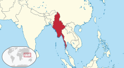
തെക്കുകിഴക്കേ ഏഷ്യൻ ഉപഭൂഖണ്ഡത്തിലെ ഏറ്റവും വലിയ രാജ്യമാണ് മ്യാൻമാർ (ഉച്ചാരണം /ˈmjɑnˌmɑ/[1]), ഔദ്യോഗികനാമം: യൂണിയൻ ഓഫ് മ്യാന്മാർ (ബർമ്മീസ്: [pjìdàunzṵ mjəmà nàinŋàndɔ̀]). ബ്രിട്ടീഷ് കോളനിയായിരുന്ന "യൂണിയൻ ഓഫ് ബർമ്മ"യ്ക്ക് 1948 ജനുവരി 4-നു ബ്രിട്ടണിൽ നിന്നും സ്വാതന്ത്ര്യം ലഭിച്ചു.1974 ജനുവരി 4-നു രാജ്യത്തിന്റെ പേര് "സോഷ്യലിസ്റ്റ് റിപ്പബ്ലിക്ക് ഓഫ് ദ് യൂണിയൻ ഓഫ് ബർമ്മ" എന്ന് മാറ്റി. 1988 സെപ്റ്റംബർ 23-നു പേര് വീണ്ടും "യൂണിയൻ ഓഫ് ബർമ്മ" എന്നുമാറ്റി. 1989 സെപ്റ്റംബർ 23-നു സ്റ്റേറ്റ് ലാ ആന്റ് ഓർഡർ റിസ്റ്റൊറേഷൻ കൗൺസിൽ രാജ്യത്തിന്റെ പേര് "യൂണിയൻ ഓഫ് മ്യാന്മാർ" എന്ന് നാമകരണം ചെയ്തു.
പീപ്പിൾസ് റിപ്പബ്ലിക്ക് ഓഫ് ചൈന (വടക്ക്), ലാവോസ് (കിഴക്ക്), തായ്ലാന്റ് (തെക്കുകിഴക്ക്), ബംഗ്ലാദേശ് (പടിഞ്ഞാറ്), ഇന്ത്യ (വടക്കുകിഴക്ക്) എന്നിവയാണ് മ്യാന്മാറിന്റെ അയൽരാജ്യങ്ങൾ. തെക്ക് ആൻഡമാൻ കടലും തെക്കുപടിഞ്ഞാറ് ബംഗാൾ ഉൾക്കടലുമാണ് സമുദ്രാതിർത്തികൾ. മ്യാന്മാറിന്റെ ചുറ്റളവിന്റെ മൂന്നിലൊന്ന് (1,930 ച.കി.മീ - 1,199 ച.മൈൽ) അഖണ്ഡമായ തീരപ്രദേശമാണ്.
വംശീയ കലാപങ്ങൾ
ജൂൺ 2012 മുതൽ മ്യാന്മാറിൽ അരാകാന സംസ്ഥാനത്തുനിന്ന് റോഹിങ്ക്യ വിഭാഗം മുസ്ലീങ്ങൾക്കെതിരേ അക്രമാസക്തമായ ജനക്കൂട്ടം അതിക്രമങ്ങൾ നടത്തുന്നുണ്ട്.[2] റോഹിങ്ക്യ വിഭാഗം മുസ്ലീങ്ങൾ ബംഗ്ലാദേശിൽ നിന്നും അനധികൃതമായി നുഴഞ്ഞുകയറിയവരാണെന്ന് ആരോപിക്കപ്പെടുന്നു.[2] അധികൃതരുടെ സഹായത്തോടെയാണ് കലാപം നടക്കുന്നതെന്ന് ഹ്യൂമൻ റൈറ്റ് വാച്ച് റിപ്പോർട്ടു ചെയ്തു. [2]
അവലംബം
- ↑ Merriam-Webster's Collegiate Dictionary (Eleventh ed.). Springfield, Massachusetts, USA: Merriam-Webster. ISBN 0-87779-807-5.
{{cite book}}: Check|isbn=value: checksum (help) - ↑ 2.0 2.1 2.2 "മ്യാൻമറിലേത് വംശഹത്യയെന്ന് ഹ്യൂമൻറൈറ്റ് വാച്ച്".
| തെക്കുകിഴക്കേ ഏഷ്യ |
|---|
|
ബ്രൂണൈ • കംബോഡിയ • ഈസ്റ്റ് ടിമോർ • ഇന്തോനേഷ്യ • ലാവോസ് • മലേഷ്യ • മ്യാൻമാർ • ഫിലിപ്പീൻസ് • സിംഗപ്പൂർ • തായ്ലാന്റ് • വിയറ്റ്നാം |


