പലോമാനി
| Palomani | |
|---|---|
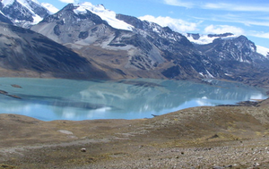
 The southern slope of Palumani (on the left) behind Suches Lake as seen from the southeast | |
| ഉയരം കൂടിയ പർവതം | |
| Elevation | 5,723[1] m (18,776 ft) |
| Coordinates | 14°43′03″S 69°14′31″W / 14.71750°S 69.24194°W |
| ഭൂമിശാസ്ത്രപരമായ പ്രത്യേകതകൾ | |
| സ്ഥാനം | Bolivia–Peru border |
| Parent range | Andes, Apolobamba |
ബൊളീവിയയുടെയും പെറുവിന്റെയും അതിർത്തിയിലുള്ള അപ്പോളോബാംബ പർവതനിരയിലെ ഒരു പർവ്വതമാണ് പലോമാനി (ഒരുപക്ഷേ അയ്മര, ഉർപി, പലുമ ഡോവ്, [2][3] "the one with a dove (or doves)"). ഇത് ഏകദേശം 5,723 മീറ്റർ (18,776 അടി) ഉയരത്തിൽ എത്തുന്നു. ലാ പാസ് ഡിപ്പാർട്ട്മെന്റ്, ഫ്രാൻസ് തമയോ പ്രവിശ്യ, പെലെചുക്കോ മുനിസിപ്പാലിറ്റിയിലെ ബൊളീവിയൻ ഭാഗത്ത് ഇത് സ്ഥിതിചെയ്യുന്നു. പെറുവിയൻ ഭാഗത്ത് അനനിയ ജില്ലയിലെ പുടിന പ്രവിശ്യയിലെ പുനോ മേഖലയിലാണ് ഇത് സ്ഥിതിചെയ്യുന്നത്. സുച്ചസ് തടാകത്തിന്റെ വടക്ക് ഭാഗത്താണ് ഇത് സ്ഥിതിചെയ്യുന്നത്. പടിഞ്ഞാറ് ചോക്ക്നക്കോട്ടയ്ക്കടുത്തുള്ള ചൗപി ഓർകോ (അല്ലെങ്കിൽ വിസ്കാചാനി), സല്ലുയു, ജിച്ചു കുല്ലു എന്നിവയ്ക്ക് തെക്ക് ഭാഗത്താണ് പലോമാനി.[4][5]
അവലംബം[തിരുത്തുക]
- ↑ John Biggar, The Andes: A Guide for Climbers, p. 126
- ↑ ഫലകം:Ref Bertonio
- ↑ Guillermo Cutipa Añamuro, Chacra qarpaña: Regando la chacra, IECTA, Iquique - Chile 2005, p. 27
- ↑ "Pelechuco". ine.gob.bo. Archived from the original on December 7, 2014. Retrieved December 15, 2014.
- ↑ escale.minedu.gob.pe - UGEL map of the Putina Province (Puno Region)


