നൊവിറ്റ്ന നദി
| നൊവിറ്റ്ന നദി | |
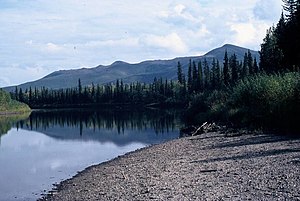
Gravel bar in the Nowitna National Wildlife Refuge
| |
| രാജ്യം | United States |
|---|---|
| സംസ്ഥാനം | Alaska |
| Census Area | Yukon–Koyukuk |
| സ്രോതസ്സ് | Kuskokwim Mountains |
| - ഉയരം | 1,688 ft (515 m) [1] |
| - നിർദേശാങ്കം | 63°30′28″N 155°32′34″W / 63.50778°N 155.54278°W [2] |
| അഴിമുഖം | Yukon River [3] |
| - സ്ഥാനം | 38 miles (61 km) northeast of Ruby |
| - ഉയരം | 154 ft (47 m) [2] |
| - നിർദേശാങ്കം | 64°55′38″N 154°16′11″W / 64.92722°N 154.26972°W [2] |
| നീളം | 250 mi (402 km) [3] |
നൊവിറ്റ്ന (Nowitna) നദി അമേരിക്കൻ ഐക്യനാടുകളിലെ സംസ്ഥാനമായ അലാസ്കയിലെ യൂക്കോൺ നദിയുടെ പോഷകനദിയാണ്. 250 മൈൽ (400 കി.മീ.) നീളമുണ്ട്. ഇത് കുസ്കോക്വിം (Kuskokwim) മലനിരകളിൽ നിന്നു വടക്കുകിഴക്കായിട്ടൊഴുകി നൊവിറ്റ്ന ദേശീയ വന്യമൃഗസങ്കേതത്തിലൂടെ കടന്നു പോകുന്നു. നൊവിറ്റന നദിയുടെ പ്രധാന പോഷകനദികൾ ടിട്ന, ബിഗ് മഡ്, ലോസ്റ്റ്, സുലാറ്റ്ന എന്നിവയാണ്.
അവലംബം[തിരുത്തുക]
- ↑ Derived by entering source coordinates in Google Earth.
- ↑ 2.0 2.1 2.2 "Nowitna River". Geographic Names Information System. United States Geological Survey. January 1, 2000. Archived from the original on 2020-06-21. Retrieved October 19, 2013.
- ↑ 3.0 3.1 Orth, Donald J.; United States Geological Survey (1971) [1967]. Dictionary of Alaska Place Names: Geological Survey Professional Paper 567 (PDF). University of Alaska Fairbanks. United States Government Printing Office. p. 705. Retrieved October 12, 2013.


