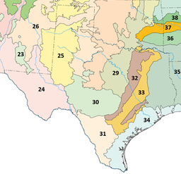
ടെക്സസ് ബ്ലാക്ക്ലാൻഡ് പ്രയറീസ്
| ടെക്സസ് ബ്ലാക്ക്ലാൻഡ് പ്രയറീസ് | |
|---|---|
 | |
 Texas blackland prairies (area 32 on the map) | |
| Ecology | |
| Ecozone | Nearctic |
| Biome | Temperate grasslands, savannas, and shrublands |
| Borders | East Central Texas forests (area 33 on the map)[2], Edwards Plateau (area 30 on the map)[2] and Cross Timbers (area 29 on the map)[2] |
| Bird species | 216[1] |
| Mammal species | 61[1] |
| Geography | |
| Area | 50,300 km2 (19,400 sq mi) |
| Country | United States |
| State | Texas |
| Climate type | Humid subtropical |
| Conservation | |
| Habitat loss | 76.458%[1] |
| Protected | 0.64%[1] |
ടെക്സസ് ബ്ലാക്ക്ലാൻഡ് പ്രയറീസ് അമേരിക്കൻ ഐക്യനാടുകളിൽ ടെക്സസ് സംസ്ഥാനത്ത് സ്ഥിതി ചെയ്യുന്ന ഒരു മിതശീതോഷ്ണ പുൽമൈതാന പ്രദേശമാണ്. ഇത് വടക്കൻ ടെക്സസിലെ റെഡ് റിവറിൽ നിന്ന് തെക്ക് സാൻ അന്റോണിയോ വരെ ഏകദേശം 300 മൈൽ (480 കി.മീ) പ്രദേശത്തേയ്ക്ക് വ്യാപിച്ചുകിടക്കുന്നു. ഈ പ്രദേശത്തെ സമൃദ്ധവും ഇരുണ്ടതുമായ മണ്ണിന്റെ പേരിലാണ് പ്രെയ്റിക്ക് പേര് ലഭിച്ചത്.[3] തുണ്ടുകളായി ടെക്സസിൽ ചിതറിക്കിടക്കുന്ന യഥാർത്ഥ ബ്ലാക്ക്ലാൻഡ് പ്രയറി സസ്യജാലങ്ങളുടെ 1 ശതമാനത്തിൽൽ താഴെ മാത്രമേ ഇന്ന് അവശേഷിക്കുന്നുള്ളൂ.[4]
അവലംബം[തിരുത്തുക]
- ↑ 1.0 1.1 1.2 1.3 Hoekstra, J. M.; Molnar, J. L.; Jennings, M.; Revenga, C.; Spalding, M. D.; Boucher, T. M.; Robertson, J. C.; Heibel, T. J.; Ellison, K. (2010). Molnar, J. L. (ed.). The Atlas of Global Conservation: Changes, Challenges, and Opportunities to Make a Difference. University of California Press. ISBN 978-0-520-26256-0.
- ↑ 2.0 2.1 2.2 "Ecoregions of Texas" (PDF). U.S. EPA. Retrieved 2016-02-06.[പ്രവർത്തിക്കാത്ത കണ്ണി]
- ↑ "Blackland Prairies". Invasives 101. Texas Invasives. Retrieved 2017-02-06.
- ↑ D’Annunzio, Francesca (2021-12-28). "North America's Most Endangered Ecoregion is in North Texas' Backyard". Dallas News.
