ഗ്രാസ് വാലി
City of Grass Valley | |
|---|---|
 The historic Holbrooke Hotel and Restaurant | |
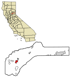
 Location of Grass Valley in Nevada County, California | |
| Coordinates: 39°13′9″N 121°3′30″W / 39.21917°N 121.05833°W | |
| Country | United States |
| State | California |
| County | Nevada |
| Incorporated | March 13, 1893[1] |
| • ആകെ | 5.25 ച മൈ (13.59 ച.കി.മീ.) |
| • ഭൂമി | 5.25 ച മൈ (13.59 ച.കി.മീ.) |
| • ജലം | 0.00 ച മൈ (0.00 ച.കി.മീ.) 0% |
| ഉയരം | 2,411 അടി (735 മീ) |
(2010) | |
| • ആകെ | 12,860 |
| • കണക്ക് (2016)[4] | 12,934 |
| • ജനസാന്ദ്രത | 2,464.09/ച മൈ (951.42/ച.കി.മീ.) |
| സമയമേഖല | UTC-8 (Pacific (PST)) |
| • Summer (DST) | UTC-7 (PDT) |
| ZIP codes | 95945, 95949 |
| Area code | 530 |
| FIPS code | 06-30798 |
| GNIS feature IDs | 277525, 2410651 |
| വെബ്സൈറ്റ് | www |
അമേരിക്കൻ ഐക്യനാടുകളിലെ കാലിഫോർണിയ സംസ്ഥാനത്ത് നെവാഡ കൗണ്ടിയുടെ പടിഞ്ഞാറൻ മേഖലയിലെ ഏറ്റവും വലിയ പട്ടണമാണ് ഗ്രാസ് വാലി. സിയേറ നെവാഡ മലനിരകളുടെ പടിഞ്ഞാറൻ മലകളുടെ താഴ്വരയിൽ സമുദ്രനിരപ്പിൽനിന്ന് ഏകദേശം 2,500 അടി (760 മീറ്റർ) ഉയരത്തിൽ സ്ഥിതി ചെയ്യുന്ന ഈ ചരിത്രപ്രാധാന്യമുള്ള വടക്കൻ ഗോൾഡ് കണ്ട്രി പട്ടണത്തിലേയ്ക്ക് സംസ്ഥാന തലസ്ഥാനമായ സാക്രമെന്റോയിൽനിന്ന് കാർമാർഗ്ഗം 57 മൈലും (92 കി.മീ) സാക്രമെന്റോ അന്താരാഷ്ട്ര വിമാനത്താവളത്തിൽനിന്ന് 64 മൈലും (103 കിലോമീറ്റർ) റെനോയ്ക്ക് പടിഞ്ഞാറ് 88 മൈലും (142 കിലോമീറ്റർ) വടക്കുകിഴക്കുള്ള സാൻ ഫ്രാൻസിസ്കോയിലേയ്ക്ക് 143 മൈൽ (230 കിലോമീറ്റർ) ദൂരവുമാണുള്ളത്.
അവലംബം[തിരുത്തുക]
- ↑ "California Cities by Incorporation Date". California Association of Local Agency Formation Commissions. Archived from the original (Word) on നവംബർ 3, 2014. Retrieved ഓഗസ്റ്റ് 25, 2014.
- ↑ "2016 U.S. Gazetteer Files". United States Census Bureau. Retrieved Jul 19, 2017.
- ↑ "Grass Valley". Geographic Names Information System. United States Geological Survey. Retrieved October 7, 2014.
- ↑ ഉദ്ധരിച്ചതിൽ പിഴവ്: അസാധുവായ
<ref>ടാഗ്;USCensusEst2016എന്ന പേരിലെ അവലംബങ്ങൾക്ക് എഴുത്തൊന്നും നൽകിയിട്ടില്ല.

