ഐർ തടാകം
ഈ ലേഖനം ഏതെങ്കിലും സ്രോതസ്സുകളിൽ നിന്നുള്ള വേണ്ടത്ര തെളിവുകൾ ഉൾക്കൊള്ളുന്നില്ല. ദയവായി യോഗ്യങ്ങളായ സ്രോതസ്സുകളിൽ നിന്നുമുള്ള അവലംബങ്ങൾ ചേർത്ത് ലേഖനം മെച്ചപ്പെടുത്തുക. അവലംബമില്ലാത്ത വസ്തുതകൾ ചോദ്യം ചെയ്യപ്പെടുകയും നീക്കപ്പെടുകയും ചെയ്തേക്കാം. |
| Kati Thanda–Lake Eyre | |
|---|---|
 Composite Landsat 7 satellite image in 1999 using shortwave infrared, near-infrared, and blue wavelengths | |
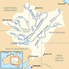
 A map of the Lake Eyre basin, with the lake at bottom left | |
| സ്ഥാനം | Northern South Australia |
| നിർദ്ദേശാങ്കങ്ങൾ | 28°22′S 137°22′E / 28.367°S 137.367°E |
| Lake type | Endorheic |
| പ്രാഥമിക അന്തർപ്രവാഹം | Warburton River |
| Primary outflows | Evaporation |
| Basin countries | Australia |
| Surface area | 9,500 km2 (3,668 sq mi) (max) |
| ശരാശരി ആഴം | 1.5 m (5 ft) (every 3 years), 4 m (13 ft) (every decade) |
| ഉപരിതല ഉയരം | −9 m (−30 ft) (shoreline when full); −15 m (−49 ft) (lowest point when empty) |
ദക്ഷിണ ഓസ്ട്രേലിയയിലെ ഒരു ലവണ ജലതടാകമാണ് ഐർ.[1] പോർട്ട് അഗസ്റ്റയ്ക്ക് 56 കി.മീ. വടക്കായി സ്ഥിതിചെയ്യുന്നു. ആഴം കുറഞ്ഞ ഈ തടാകത്തിന്റെ പരമാവധി നീളം : 200 കി.മീ.; വീതി: 50 കി.മീ.; വിസ്തീർണം : 5780 ച.കി.മീ. 1840-ൽ എഡ്വാർഡ് ജോൺ ഐർ ആണ് ഐർ തടാകം കണ്ടെത്തിയത്.
സ്പെൻസർ ഉൾക്കടലിനു വടക്കായാണ് ഐർ തടാകം സ്ഥിതിചെയ്യുന്നത്. . വർഷത്തിൽ 200 മി.മീ. -നു താഴെ മാത്രം മഴ ലഭിക്കുന്ന പ്രദേശത്തിലായതിനാൽ ഉപ്പുരസമുള്ള ജലം നിറഞ്ഞ ചതുപ്പുനിലംപോലെയാണ് ഐർ തടാകം മിക്കപ്പോഴും കാണപ്പെടുന്നത്. ആഗമന-ബഹിർഗമന അരുവികളുടെ അഭാവം ഈ തടാകത്തിന്റെ പ്രത്യേകതയാണ്.
1840-ൽ ആദ്യമായി യൂറോപ്യൻ ആയിരുന്ന എഡ്വേർഡ് ജോൺ ഐറിൻറെ ബഹുമാനാർത്ഥം ഈ തടാകത്തിന് യൂറോപ്യൻമാർ പേര് നൽകി. തടാകത്തിന്റെ ഔദ്യോഗിക നാമം 2012 ഡിസംബറിൽ മാറ്റി "ഐർ തടാകം" എന്ന പേര് തദ്ദേശീയ നാമമായ കാറ്റി തണ്ടയുമായി സംയോജിപ്പിച്ചു. [1] തടാകത്തിനും ചുറ്റുമുള്ള പ്രദേശത്തിനും നേറ്റീവ് ടൈറ്റിൽ അരബാന ജനത നൽകിയിരിക്കുന്നു.[2]
അവലംബം[തിരുത്തുക]
- ↑ 1.0 1.1 "New name adopted for outback Lake Eyre". Australian Broadcasting Corporation. 19 December 2012. Retrieved 19 December 2012.
- ↑ "Federal Court awards native title over Lake Eyre". ABC News. Australia. 23 May 2012. Retrieved 2 January 2012.
കൂടുതൽ വായനയ്ക്ക്[തിരുത്തുക]
- Schwarz, Dominique (10 May 2019). "The re-birth of Lake Eyre" (video). ABC News. 7:30 Report. Australian Broadcasting Corporation.
- Dr Vincent Kotwicki: Floods of Lake Eyre Archived 2006-08-21 at the Wayback Machine. - interesting site with lots of data, including Lake Eyre inflows 1885-2012.
- Salt Archived 2019-11-17 at the Wayback Machine. - documentary film by Murray Fredericks and Michael Angus (synopsis)
