ആർലിങ്ടൺ, വിർജീനിയ
| Arlington County, Virginia | |||||
|---|---|---|---|---|---|
| County | |||||
| Arlington County | |||||
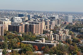
 The skylines of Arlington's Courthouse and Rosslyn neighborhoods, with the Georgetown and Downtown neighborhoods of Washington, D.C. immediately past them. The county accounts for most of Virginia's border with the District. | |||||
| |||||
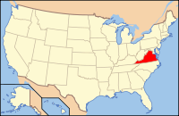
 Location in the U.S. state of Virginia | |||||
 Virginia's location in the U.S. | |||||
| സ്ഥാപിതം | February 27, 1801 | ||||
| Named for | Arlington House | ||||
| സീറ്റ് | Arlington | ||||
| വിസ്തീർണ്ണം | |||||
| • ആകെ. | 26 sq mi (67 km2) | ||||
| • ഭൂതലം | 26 sq mi (67 km2) | ||||
| • ജലം | 0.2 sq mi (1 km2), 0.4% | ||||
| ജനസംഖ്യ (est.) | |||||
| • (2017) | 234,965 | ||||
| • ജനസാന്ദ്രത | 9,037/sq mi (3,489/km²) | ||||
| Congressional district | 8th | ||||
| സമയമേഖല | Eastern: UTC-5/-4 | ||||
| Website | www | ||||
കോമൺവെൽത്ത് ഓഫ് വെർജീനിയയിലെ ഒരു കൗണ്ടിയാണ് ആർലിങ്ടൺ.[1] 2016 ലെ കണക്കുകൂട്ടലിൽ ഈ കൌണ്ടിയിലെ ആകെ ജനസംഖ്യ 230,050 ആണെന്ന് കണ്ടെത്തിയിരുന്നു. ഇത് വിർജീനിയയിലെ ആറാമത്തെ ഏറ്റവും വലിയ കൗണ്ടിയാണ്, അഥവാ മറ്റുള്ളവയേപ്പോലെ ഒരു നഗരമായി സംയോജിപ്പിക്കപ്പെട്ടിരുന്നവെങ്കിൽ ഇത് സംസ്ഥാനത്തെ നാലാമത്തെ വലിയ നഗരമാകുമായിരുന്നു. ശരാശരി കുടുംബ വരുമാനം[2] കണക്കാക്കിയയാൽ ഇത് യു എസിലെ അഞ്ചാമത്തെ ഏറ്റവും ഉയർന്ന വരുമാനമുള്ള കൗണ്ടിയാണ്, അതുപോലെ കൂടുതൽ അവിവാഹിതർ കേന്ദ്രീകരിച്ചിരിക്കുന്ന മേഖലയുമാണിത്.[3]
അവലംബം[തിരുത്തുക]
- ↑ "OMB BULLETIN NO. 13-01" (PDF). WhiteHouse.gov. Archived from the original (PDF) on January 18, 2017.
- ↑ "Washington region boasts four richest counties in U.S." American City Business Journals.
- ↑ Annie Gowen (November 7, 2009). "Fresh faces, thick wallets". Washington Post. Washington Post. pp. B4.


