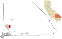
ആപ്പിൾ വാലി, കാലിഫോർണിയ
ആപ്പിൾ വാലി, കാലിഫോർണിയ | ||
|---|---|---|
| ||
| Nickname(s): "Apple of the Desert" | ||
| Motto(s): "A Better Way of Life!" | ||
 Location of Apple Valley in California | ||
| Coordinates: 34°30′03″N 117°11′09″W / 34.50083°N 117.18583°W[1] | ||
| Country | ||
| State | ||
| County | ||
| Incorporated | November 28, 1988[2] | |
| • City council[3] | Mayor Larry Cusack, Mayor Pro Tem Barb Stanton, Art Bishop, Curt Emick, and Scott Nassif | |
| • ആകെ | 73.523 ച മൈ (190.426 ച.കി.മീ.) | |
| • ഭൂമി | 73.193 ച മൈ (189.570 ച.കി.മീ.) | |
| • ജലം | 0.330 ച മൈ (0.856 ച.കി.മീ.) 0.45% | |
| ഉയരം | 2,946 അടി (898 മീ) | |
| • ആകെ | 69,135 | |
| • കണക്ക് (2013)[5] | 70,924 | |
| • ജനസാന്ദ്രത | 940/ച മൈ (360/ച.കി.മീ.) | |
| സമയമേഖല | UTC-8 (Pacific Time Zone) | |
| • Summer (DST) | UTC-7 (PDT) | |
| ZIP codes | 92307, 92308 [6] | |
| Area code | 442/760[7] | |
| FIPS code | 06-02364 | |
| GNIS feature IDs | 1660259, 2412372 | |
| വെബ്സൈറ്റ് | www | |
ആപ്പിൾ വാലി പട്ടണം, അമേരിക്കൻ ഐക്യനാടുകളിലെ കാലിഫോർണിയ സംസ്ഥാനത്തെ സാൻ ബർണാർഡിനോ കൗണ്ടിയിലെ വിക്ടർ താഴ്വരയിലാണ് സ്ഥിതി ചെയ്യുന്നത്. 1988 നവംബർ 14 നാണ് ഇത് സംയോജിപ്പിച്ചത്. കാലിഫോർണിയയിലെ ഇരുപത്തിരണ്ട് സംയോജിപ്പിക്കപ്പെട്ട മുനിസിപ്പാലിറ്റികളിലൊന്നായ ഇത് "നഗരം" എന്നതിനുപകരം "ടൗൺ" എന്നാണ് ഉപയോഗിക്കുന്നത്. വിക്ടർവില്ലെ, ഹെസ്പെരിയ തുടങ്ങിയ അയൽ പട്ടണങ്ങളുമായി കിഴക്കുഭാഗത്ത് ഈ പട്ടണം സന്ധിക്കുന്നു. അതുപോലെ കജോൻ ചുരം വഴി ബർസ്റ്റോയ്ക്ക് 37 മൈൽ (60 കിലോമീറ്റർ) തെക്കായും സാൻ ബെർനാർഡിനോയ്ക്ക് 46 മൈൽ (74 കിലോമീറ്റർ)വടക്കായുമാണ് ഇതിൻറ സ്ഥാനം. 2010 ലെ സെൻസസിൽ ഈ പട്ടണത്തിലെ ആകെ ജനസംഖ്യ 69,135 ആയിരുന്നു. ആപ്പിൾ വാലിയുടെ ഭരണം നിയന്ത്രിക്കുന്നത് ഒരു ടൌൺ കൗൺസിലാണ്.
1967 ൽ ആപ്പിൾ വാലിയിൽ, റോയ് റോജേഴ്സ്, ഡെയ്ൽ ഇവാൻസ് എന്നിവർചേർന്ന് ആദ്യമായി ഒരു മ്യൂസിയം സ്ഥാപിച്ചുവെങ്കിലും പിന്നീട് 1976 ൽ വിക്ടർവില്ലെയിലേയ്ക്കു മാറ്റി സ്ഥാപിക്കപ്പെട്ടു. 2003 മുതൽ മിസ്സോറിയിലെ ബ്രാൻസണിലാണ് മ്യൂസിയം പ്രവർത്തിച്ചിരുന്നത്. കൂടുതൽ ആരാധകരെ[8] എത്തിക്കാനുള്ള പ്രതീക്ഷയിലാണ് ഈ നീക്കം നടന്നതെങ്കിലും 2009 ഡിസംബർ 12 ന് മ്യൂസിയം സാമ്പത്തിക കാരണങ്ങളാൽ അടച്ചുപൂട്ടപ്പെട്ടു.[9]
ഭൂമിശാസ്ത്രം[തിരുത്തുക]
ആപ്പിൾവാലി സ്ഥിതിചെയ്യുന്ന അക്ഷാംശരേഖാംശങ്ങൾ 34°31′N 117°13′W / 34.517°N 117.217°W (34.5115, -117.2120) ആണ്.[10] ഈ ടൌൺ, മോജാവെ മരുഭൂമിയുടെ തെക്കെ അറ്റത്തായി സ്ഥിതി ചെയ്യുന്നു.
അവലംബം[തിരുത്തുക]
- ↑ 1.0 1.1 "Apple Valley". Geographic Names Information System. United States Geological Survey. Retrieved November 12, 2014.
- ↑ "California Cities by Incorporation Date". California Association of Local Agency Formation Commissions. Archived from the original (Word) on November 3, 2014. Retrieved August 25, 2014.
- ↑ "Town Council". Town of Apple Valley. Archived from the original on 2015-02-03. Retrieved January 14, 2015.
- ↑ "2010 Census U.S. Gazetteer Files – Places – California". United States Census Bureau.
- ↑ 5.0 5.1 "Apple Valley (town) QuickFacts". United States Census Bureau. Archived from the original on 2012-08-16. Retrieved February 26, 2015.
- ↑ "USPS - ZIP Code Lookup - Find a ZIP+ 4 Code By City Results". Retrieved 2007-02-20.
- ↑ "Number Administration System - NPA and City/Town Search Results". Archived from the original on 2007-09-26. Retrieved 2007-02-20.
- ↑ Victor Valley Daily Press. February 14, 2009 http://www.vvdailypress.com/news/museum_10892___article.html/roy_rogers.html?orderby=TimeStampDescending&oncommentsPage=2&showRecommendedOnly=0#slComments Archived 2013-02-05 at Archive.is[പ്രവർത്തിക്കാത്ത കണ്ണി]
- ↑ Special Announcement from Roy Rogers Jr. http://www.royrogers.com/announcement.html Archived 2016-11-07 at the Wayback Machine.
- ↑ "US Gazetteer files: 2010, 2000, and 1990". United States Census Bureau. 2011-02-12. Retrieved 2011-04-23.


