
ബറാടങ് ദ്വീപ്
| Geography | |
|---|---|
| Location | Bay of Bengal |
| Coordinates | 12°11′N 92°48′E / 12.18°N 92.80°E |
| Archipelago | Andaman Islands |
| Area | 242.6 km2 (93.7 sq mi) |
| Length | 27.8 km (17.27 mi) |
| Width | 14 km (8.7 mi) |
| Coastline | 117 km (72.7 mi) |
| Highest elevation | 76 m (249 ft) |
| Administration | |
| Demographics | |
| Population | 5691 |
| Additional information | |
| Official website | www |
ആന്തമാൻ ദ്വീപുസമൂഹത്തിലെ ഒരു ദ്വീപാണ് ബറാടങ് ദ്വീപ് (Baratang Island). ഇന്ത്യയുടെ കേന്ദ്രഭരണപ്രദേശമായ ആൻഡമാൻ നിക്കോബാർ ദ്വീപുകളുടെ ഉത്തര-മദ്ധ്യ ആൻഡമാൻ ഭരണജില്ലയുടെ ഭാഗങ്ങളിലുൾപ്പെടുന്നതാണ് ബറാടങ് ദ്വീപ്.[2]
പോർട്ട് ബ്ലെയറിൽ 150 കിലോമീറ്റർ വടക്കുമാറിയാണ് ഈ ദ്വീപ് സ്ഥിതിചെയ്യുന്നത്.
ചരിത്രം[തിരുത്തുക]
1985 ൽ ഒരു വിളക്കുമാടം നിർമ്മാണം പൂർത്തിയാക്കിയിട്ടുണ്ട്. [3]
ഭരണം[തിരുത്തുക]
ഭരണപരമായി ബറാടങ് ദ്വീപ് റംഗത്ത് താലൂക്കിന്റെ ഭാഗമാണ്[4]
ചിത്രശാല[തിരുത്തുക]
-
 Location of Baratang
 -
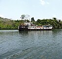 Ferry at Middle Strait jetty, Baratang
 -
 Baratang Island Middle Strait jetty
 -
 Baratang Island Middle Strait jetty
 -
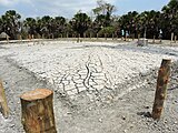 Mud Volcano of Baratang Island
 -
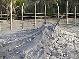 Mud Volcano of Baratang Island


അവലംബം[തിരുത്തുക]
- ↑ Registration Plate Numbers added to ISO Code
- ↑ "Village Code Directory: Andaman & Nicobar Islands" (PDF). Census of India. Retrieved 2011-01-16.
- ↑ "Government of India, Directorate General of Lighthouses and Lightships". www.dgll.nic.in. Retrieved 2016-10-18.
- ↑ "DEMOGRAPHIC – A&N ISLANDS" (PDF). andssw1.and.nic.in. Retrieved 2016-09-23.
- Geological Survey of India Archived 2005-07-28 at the Wayback Machine.