
പ്രമാണം:US Secession map 1863 (BlankMap derived).png

ഈ പ്രിവ്യൂവിന്റെ വലിപ്പം: 800 × 488 പിക്സലുകൾ. മറ്റ് റെസലൂഷനുകൾ: 320 × 195 പിക്സലുകൾ | 640 × 390 പിക്സലുകൾ | 841 × 513 പിക്സലുകൾ.
പൂർണ്ണ വലിപ്പം (841 × 513 പിക്സൽ, പ്രമാണത്തിന്റെ വലിപ്പം: 24 കെ.ബി., മൈം തരം: image/png)
| ഈ പ്രമാണം വിക്കിമീഡിയ കോമൺസിൽ നിന്നുള്ളതാണ്. പ്രമാണത്തെക്കുറിച്ചുള്ള വിവരണം താഴെ കൊടുത്തിരിക്കുന്നു.
|
.png?uselang=ml)

|
ഈ locator map ചിത്രം വെക്റ്റർ ഗ്രാഫിക്സ് ഉപയോഗിച്ച് എസ്.വി.ജി. പ്രമാണമായി പുനർനിർമ്മിക്കേണ്ടതാണ്. അങ്ങനെ ചെയ്യുന്നതുകൊണ്ട് പല ഗുണങ്ങളുമുണ്ട്; കൂടുതൽ വിവരങ്ങൾക്ക് മെച്ചപ്പെടുത്തുവാനുള്ള മീഡിയകൾ കാണുക. ഈ ചിത്രത്തിന്റെ എസ്.വി.ജി. പതിപ്പ് കൈവശമുണ്ടെങ്കിൽ ദയവായി അപ്ലോഡ് ചെയ്യുക. അപ്ലോഡ് ചെയ്ത ശേഷം ഈ ഫലകം {{vector version available|പുതിയ ചിത്രത്തിന്റെ പേര്.svg}} എന്ന് മാറ്റിച്ചേർക്കുക.
|
ചുരുക്കം
| വിവരണം |
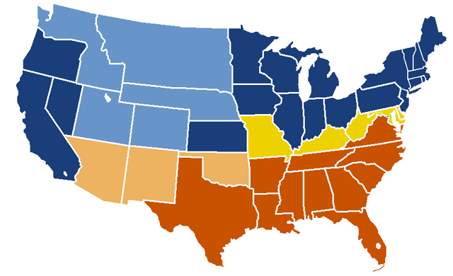
English: United States map of 1863, show affiliation of states and territories regarding the Secession War (Civil War.) Legend:
Union states Union territories not permitting slavery Border Union states, permitting slavery Confederate states Union territories permitting slavery (claimed by Confederacy) |
| തീയതി | യഥാർത്ഥ അപ്ലോഡ് തീയതി: 19:04, 24 February 2007 |
| സ്രോതസ്സ് |
|
| സ്രഷ്ടാവ് | w:en:Porsche997SBS (സംവാദം | സംഭാവനകൾ) |
അനുമതി
ഈ ഭൂപടം അമേരിക്കൻ ഐക്യനാടുകളിലെ ദേശീയ അറ്റ്ലസിന്റെ ഒരു പതിപ്പിൽ നിന്നും എടുത്തിട്ടുള്ളതാണ്. അമേരിക്കൻ ഐക്യനാടുകളിലെ ഭരണകൂടത്തിന്റെ മിക്കവാറും എല്ലാ സൃഷ്ടികളേയും പോലെ, ദേശീയ അറ്റ്ലസിന്റെ സൃഷ്ടികളും പൊതുസഞ്ചയത്തിൽ പെടുന്നു.
ഓൺലൈൻ ലഭ്യത: NationalAtlas.gov | അച്ചടി രൂപം 1970: ലൈബ്രറി ഓഫ് കോൺഗ്രസ്, പെറി-കസ്താൻഡ ഗ്രന്ഥശാല
|
യഥാർത്ഥ അപ്ലോഡ് രേഖ
| date/time | username | resolution | size | edit summary |
|---|---|---|---|---|
| 19:04, 24 February 2007 | w:en:User:Porsche997SBS | 841×513 | 24 KB | trimming blankness |
| 18:59, 24 February 2007 | w:en:User:Porsche997SBS | 841×580 | 25 KB | don't need that |
| 18:55, 24 February 2007 | w:en:User:Porsche997SBS | 841×580 | 29 KB | format based on [http://en.wikipedia.org/wiki/Image:BlankMap-USA-states.PNG this image]; information from [http://en.wikipedia.org/wiki/Image:US_Secession_map_1865.svg this image]; see description pages there |
Image description page history
| link | date/time | username | edit summary |
|---|---|---|---|
| http://en.wikipedia.org/w/index.php?title=Image:US_Secession_map_1865_(BlankMap_derived).PNG&redirect=no&oldid=110635613 | 07:40, 10 September 2007 | w:en:User:Dmcdevit | |
| http://en.wikipedia.org/w/index.php?title=Image:US_Secession_map_1865_(BlankMap_derived).PNG&redirect=no&oldid=110635613 | 19:02, 24 February 2007 | w:en:User:Porsche997SBS | |
| http://en.wikipedia.org/w/index.php?title=Image:US_Secession_map_1865_(BlankMap_derived).PNG&redirect=no&oldid=110634272 | 18:55, 24 February 2007 | w:en:User:Porsche997SBS | (format based on [http://en.wikipedia.org/wiki/Image:BlankMap-USA-states.PNG this image]; information from [http://en.wikipedia.org/wiki/Image:US_Secession_map_1865.svg this image]; see description pages there) |
.PNG&redirect=no&oldid=110635613)
.PNG&redirect=no&oldid=110634272)
പ്രമാണ നാൾവഴി
ഏതെങ്കിലും തീയതി/സമയ കണ്ണിയിൽ ഞെക്കിയാൽ പ്രസ്തുതസമയത്ത് ഈ പ്രമാണം എങ്ങനെയായിരുന്നു എന്നു കാണാം.
| തീയതി/സമയം | ലഘുചിത്രം | അളവുകൾ | ഉപയോക്താവ് | അഭിപ്രായം | |
|---|---|---|---|---|---|
| നിലവിലുള്ളത് | 21:08, 14 ജനുവരി 2010 | | 841 × 513 (24 കെ.ബി.) | Porsche997SBS | Reverted to version as of 09:03, 14 January 2010--so frustrating |
| 21:07, 14 ജനുവരി 2010 |  | 841 × 513 (12 കെ.ബി.) | Porsche997SBS | let's try again | |
| 09:03, 14 ജനുവരി 2010 |  | 841 × 513 (24 കെ.ബി.) | Porsche997SBS | upload error? | |
| 08:52, 14 ജനുവരി 2010 |  | 841 × 513 (24 കെ.ബി.) | Porsche997SBS | fixing Nebraska, Dakota, and Washington territories and the border between Nevada and Utah | |
| 07:56, 14 ജനുവരി 2010 |  | 841 × 513 (24 കെ.ബി.) | Porsche997SBS | gray to blue | |
| 08:32, 29 ഡിസംബർ 2007 |  | 841 × 513 (24 കെ.ബി.) | Porsche997SBS | updating red to grey | |
| 16:45, 13 സെപ്റ്റംബർ 2007 |  | 841 × 513 (24 കെ.ബി.) | BetacommandBot | Transwiki approved by: w:en:User:Dmcdevit This image was copied from wikipedia:en. The original description was: format based on [http://en.wikipedia.org/wiki/Image:BlankMap-USA-states.PNG this image]; information from [http://en.wikipedia.org/wiki/ |
പ്രമാണത്തിന്റെ ഉപയോഗം
താഴെ കാണുന്ന താളിൽ ഈ ചിത്രം ഉപയോഗിക്കുന്നു:
പ്രമാണത്തിന്റെ ആഗോള ഉപയോഗം
താഴെ കൊടുത്തിരിക്കുന്ന മറ്റ് വിക്കികൾ ഈ പ്രമാണം ഉപയോഗിക്കുന്നു:
- anp.wikipedia.org സംരംഭത്തിലെ ഉപയോഗം
- ar.wikipedia.org സംരംഭത്തിലെ ഉപയോഗം
- azb.wikipedia.org സംരംഭത്തിലെ ഉപയോഗം
- cs.wikipedia.org സംരംഭത്തിലെ ഉപയോഗം
- eml.wikipedia.org സംരംഭത്തിലെ ഉപയോഗം
- en.wikipedia.org സംരംഭത്തിലെ ഉപയോഗം
- eo.wikipedia.org സംരംഭത്തിലെ ഉപയോഗം
- he.wikipedia.org സംരംഭത്തിലെ ഉപയോഗം
- hi.wikipedia.org സംരംഭത്തിലെ ഉപയോഗം
- hu.wikipedia.org സംരംഭത്തിലെ ഉപയോഗം
- hy.wikipedia.org സംരംഭത്തിലെ ഉപയോഗം
- ja.wikipedia.org സംരംഭത്തിലെ ഉപയോഗം
- kk.wikipedia.org സംരംഭത്തിലെ ഉപയോഗം
- kn.wikipedia.org സംരംഭത്തിലെ ഉപയോഗം
- ko.wikipedia.org സംരംഭത്തിലെ ഉപയോഗം
- la.wikipedia.org സംരംഭത്തിലെ ഉപയോഗം
- lt.wikipedia.org സംരംഭത്തിലെ ഉപയോഗം
- pt.wikipedia.org സംരംഭത്തിലെ ഉപയോഗം
- ru.wikipedia.org സംരംഭത്തിലെ ഉപയോഗം
- si.wikipedia.org സംരംഭത്തിലെ ഉപയോഗം
- sk.wikipedia.org സംരംഭത്തിലെ ഉപയോഗം
- th.wikipedia.org സംരംഭത്തിലെ ഉപയോഗം
- vi.wikipedia.org സംരംഭത്തിലെ ഉപയോഗം
.png)