
പ്രമാണം:Northern Mariana Islands map.gif
കൂടുതൽ വ്യക്തതയുള്ള ചിത്രം ലഭ്യമല്ല.
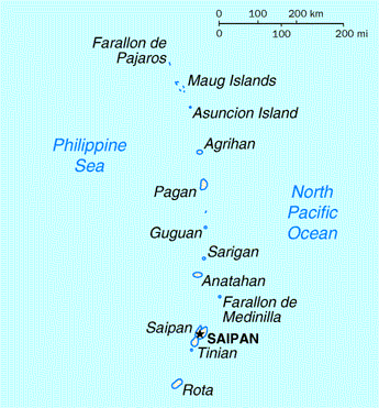
Northern_Mariana_Islands_map.gif (345 × 371 പിക്സൽ, പ്രമാണത്തിന്റെ വലിപ്പം: 24 കെ.ബി., മൈം തരം: image/gif)
| ഈ പ്രമാണം വിക്കിമീഡിയ കോമൺസിൽ നിന്നുള്ളതാണ്. പ്രമാണത്തെക്കുറിച്ചുള്ള വിവരണം താഴെ കൊടുത്തിരിക്കുന്നു.
|
ചുരുക്കം
| വിവരണം | Map of the Northern Mariana Islands |
| സ്രോതസ്സ് | http://www.doi.gov/oia/Islandpages/cnmipage.htm |
| സ്രഷ്ടാവ് | United States Department of the Interior |
അനുമതി
| This image or media file contains material based on a work of a United States Department of the Interior employee, created as part of that person's official duties. As a work of the U.S. federal government, such work is in the public domain in the United States. See the Department of the Interior copyright policy for more information. |  |
പ്രമാണ നാൾവഴി
ഏതെങ്കിലും തീയതി/സമയ കണ്ണിയിൽ ഞെക്കിയാൽ പ്രസ്തുതസമയത്ത് ഈ പ്രമാണം എങ്ങനെയായിരുന്നു എന്നു കാണാം.
| തീയതി/സമയം | ലഘുചിത്രം | അളവുകൾ | ഉപയോക്താവ് | അഭിപ്രായം | |
|---|---|---|---|---|---|
| നിലവിലുള്ളത് | 03:17, 18 ഓഗസ്റ്റ് 2010 | | 345 × 371 (24 കെ.ബി.) | Ras67 | cropped |
| 00:24, 17 മേയ് 2008 |  | 351 × 377 (25 കെ.ബി.) | Scanlan | {{Information |Description=Map of the Northern Mariana Islands |Source=http://www.doi.gov/oia/Islandpages/cnmipage.htm |Date= |Author=United States Department of the Interior |Permission= |other_versions= }} [[Category:Maps of the Northern Marian |
പ്രമാണത്തിന്റെ ഉപയോഗം
താഴെ കാണുന്ന താളിൽ ഈ ചിത്രം ഉപയോഗിക്കുന്നു:
പ്രമാണത്തിന്റെ ആഗോള ഉപയോഗം
താഴെ കൊടുത്തിരിക്കുന്ന മറ്റ് വിക്കികൾ ഈ പ്രമാണം ഉപയോഗിക്കുന്നു:
- af.wikipedia.org സംരംഭത്തിലെ ഉപയോഗം
- ar.wikipedia.org സംരംഭത്തിലെ ഉപയോഗം
- ast.wikipedia.org സംരംഭത്തിലെ ഉപയോഗം
- be-tarask.wikipedia.org സംരംഭത്തിലെ ഉപയോഗം
- bn.wikipedia.org സംരംഭത്തിലെ ഉപയോഗം
- ch.wikipedia.org സംരംഭത്തിലെ ഉപയോഗം
- cs.wikipedia.org സംരംഭത്തിലെ ഉപയോഗം
- cy.wikipedia.org സംരംഭത്തിലെ ഉപയോഗം
- da.wikipedia.org സംരംഭത്തിലെ ഉപയോഗം
- en.wikipedia.org സംരംഭത്തിലെ ഉപയോഗം
- es.wikipedia.org സംരംഭത്തിലെ ഉപയോഗം
- fa.wikipedia.org സംരംഭത്തിലെ ഉപയോഗം
- fr.wikipedia.org സംരംഭത്തിലെ ഉപയോഗം
- he.wikipedia.org സംരംഭത്തിലെ ഉപയോഗം
- id.wikipedia.org സംരംഭത്തിലെ ഉപയോഗം
- incubator.wikimedia.org സംരംഭത്തിലെ ഉപയോഗം
- io.wikipedia.org സംരംഭത്തിലെ ഉപയോഗം
- ja.wikipedia.org സംരംഭത്തിലെ ഉപയോഗം
- ka.wikipedia.org സംരംഭത്തിലെ ഉപയോഗം
- mr.wikipedia.org സംരംഭത്തിലെ ഉപയോഗം
- pt.wikipedia.org സംരംഭത്തിലെ ഉപയോഗം
- ru.wikipedia.org സംരംഭത്തിലെ ഉപയോഗം
- ta.wikipedia.org സംരംഭത്തിലെ ഉപയോഗം
- to.wikipedia.org സംരംഭത്തിലെ ഉപയോഗം
- tr.wiktionary.org സംരംഭത്തിലെ ഉപയോഗം
- tt.wikipedia.org സംരംഭത്തിലെ ഉപയോഗം
- uk.wikipedia.org സംരംഭത്തിലെ ഉപയോഗം