
പ്രമാണം:IrishSeaReliefMap.jpg
ഈ പ്രിവ്യൂവിന്റെ വലിപ്പം: 415 × 600 പിക്സലുകൾ. മറ്റ് റെസലൂഷനുകൾ: 166 × 240 പിക്സലുകൾ | 332 × 480 പിക്സലുകൾ | 531 × 768 പിക്സലുകൾ | 1,043 × 1,507 പിക്സലുകൾ.
പൂർണ്ണ വലിപ്പം (1,043 × 1,507 പിക്സൽ, പ്രമാണത്തിന്റെ വലിപ്പം: 2.15 എം.ബി., മൈം തരം: image/jpeg)
| ഈ പ്രമാണം വിക്കിമീഡിയ കോമൺസിൽ നിന്നുള്ളതാണ്. പ്രമാണത്തെക്കുറിച്ചുള്ള വിവരണം താഴെ കൊടുത്തിരിക്കുന്നു.
|
ചുരുക്കം
| വിവരണം |
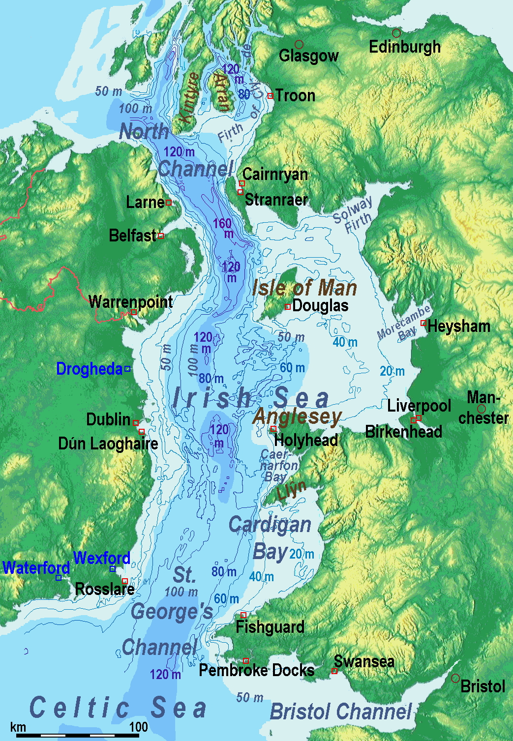
A map of the en:Irish Sea. Major ports shown with red marks. freight-only ports in blue. |
| തീയതി | old map 2005-08-03; new map 2014-05-11 |
| സ്രോതസ്സ് | old map: http://www.vindaloo.uklinux.net/jjg/code/tmutils.html-> new map: Maps for Free and സ്വന്തം സൃഷ്ടി |
| സ്രഷ്ടാവ് | old one Users SFC9394, Seabhcan on en.wikipedia, new one Ulamm (talk) 01:37, 11 May 2014 (UTC) |
| അനുമതി (ഈ പ്രമാണത്തിന്റെ പുനരുപയോഗം) |
old map: from http://www.vindaloo.uklinux.net/jjg/code/tmutils.html. Released to public domain by creator. |
| മറ്റു പതിപ്പുകൾ |
History of the od map
Old map riginally from en.wikipedia; description page is (was) here
- 14:22, 20 March 2006 SFC9394 461×561 (85,860 bytes) (Corrected locations for Cairnryan & Stranraer)
- 10:56, 25 November 2005 Seabhcan 461×561 (73,292 bytes) (Removed the ports of Heysham and Fleetwood, to which en:User:Robdurbar took offence. )
- 16:23, 3 August 2005 Seabhcan 461×561 (95,162 bytes) (Added channel names)
- 15:50, 3 August 2005 Seabhcan 461×561 (93,219 bytes) (A map of the en:Irish Sea Major ports shown in red. freight only ports in blue. from [1]. Released to public domain by creator.)
Sources of information for the new map
- internal report Nr. 174 of the National Oceanography Centre (Liverpool)
- http://www.dcenr.gov.ie (Department of Communications, Energy and Natural Resources) -> IOSEA4Annex–Master–r02–Fiinal.pdf (Fourth Strategic Environmental Assessment for Oil and Gas ACtivity in Irelands Offshore Waters) -> figures 2.1 & 2.2a
അനുമതി
ഈ സൃഷ്ടിയുടെ പകർപ്പവകാശ ഉടമയായ ഞാൻ, താഴെ പറയുന്ന അനുമതിയിൽ ഈ സൃഷ്ടി ഇതിനാൽ പ്രസിദ്ധീകരിക്കുന്നു:
ഈ പ്രമാണത്തിന് അനുമതി നൽകപ്പെട്ടിരിക്കുന്നത് ക്രിയേറ്റീവ് കോമൺസ് ആട്രിബ്യൂഷൻ-ഷെയർ എലൈക് 3.0 അൺപോർട്ടഡ് അനുവാദപത്ര പ്രകാരമാണ്.
- താങ്കൾക്കുള്ള സ്വാതന്ത്ര്യങ്ങൾ:
- പങ്ക് വെയ്ക്കൽ – കൃതി പകർത്താനും, വിതരണം ചെയ്യാനും, പ്രസരിപ്പിക്കാനും
- പുനഃമിശ്രണം ചെയ്യൽ – കൃതി അനുയുക്തമാക്കാൻ
- താഴെ പറയുന്ന ഉപാധികൾ പാലിക്കുക:
- കടപ്പാട് – രചയിതാവോ അനുമതിയുള്ളയാളോ വ്യക്തമാക്കിയിട്ടുള്ള വിധത്തിൽ കൃതിയ്ക്കുള്ള കടപ്പാട് താങ്കൾ നൽകിയിരിക്കണം. താങ്കൾക്കിത് ഏത് വിധത്തിൽ വേണമെങ്കിലും ചെയ്യാവുന്നതാണ്, പക്ഷേ അത് അവർ താങ്കളേയോ താങ്കളുടെ ഉപയോഗത്തേയോ അടിച്ചേൽപ്പിച്ചതു പോലെയാവരുത്.
- ഇതു പോലെ പങ്ക് വെയ്ക്കുക – ഈ സൃഷ്ടിയെ പുനഃമിശ്രണം ചെയ്തോ രൂപാന്തരപ്പെടുത്തിയോ അടിസ്ഥാനപ്പെടുത്തിയോ ഉണ്ടാക്കുന്നവ; താങ്കളുടെ സംഭാവനയടക്കമുള്ള സൃഷ്ടി യഥാർത്ഥ സൃഷ്ടിയുടെ അതേ അല്ലെങ്കിൽ അനുരൂപമായ ഉപയോഗാനുമതിയിൽ മാത്രമേ താങ്കൾ വിതരണം ചെയ്യാവൂ.
(Uploaded using CommonsHelper or PushForCommons)
പ്രമാണ നാൾവഴി
ഏതെങ്കിലും തീയതി/സമയ കണ്ണിയിൽ ഞെക്കിയാൽ പ്രസ്തുതസമയത്ത് ഈ പ്രമാണം എങ്ങനെയായിരുന്നു എന്നു കാണാം.
| തീയതി/സമയം | ലഘുചിത്രം | അളവുകൾ | ഉപയോക്താവ് | അഭിപ്രായം | |
|---|---|---|---|---|---|
| നിലവിലുള്ളത് | 11:42, 13 മേയ് 2014 | | 1,043 × 1,507 (2.15 എം.ബി.) | Ulamm | optimized colour scale |
| 14:17, 12 മേയ് 2014 |  | 1,043 × 1,507 (1.87 എം.ബി.) | Ulamm | more names, smaller letters | |
| 12:25, 11 മേയ് 2014 |  | 1,043 × 1,449 (1.73 എം.ബി.) | Ulamm | depths and names of bays and inlets | |
| 10:56, 11 മേയ് 2014 |  | 1,043 × 1,449 (1.71 എം.ബി.) | Ulamm | land colours lightened | |
| 02:22, 11 മേയ് 2014 |  | 1,043 × 1,449 (1.7 എം.ബി.) | Ulamm | more ports | |
| 01:50, 11 മേയ് 2014 |  | 1,043 × 1,449 (1.69 എം.ബി.) | Ulamm | completion outside the Irish Sea | |
| 01:39, 11 മേയ് 2014 |  | 1,043 × 1,449 (1.68 എം.ബി.) | Ulamm | completely new map | |
| 09:01, 1 നവംബർ 2006 |  | 461 × 561 (84 കെ.ബി.) | Korrigan | {{Information| |Description= A map of the en:Irish Sea Major ports shown in red. freight only ports in blue. |Source= |Date= |Author=Users SFC9394, Seabhcan on [http://en.wikipedia.org en.wikipedia] |Permiss |
പ്രമാണത്തിന്റെ ഉപയോഗം
താഴെ കാണുന്ന താളിൽ ഈ ചിത്രം ഉപയോഗിക്കുന്നു:
പ്രമാണത്തിന്റെ ആഗോള ഉപയോഗം
താഴെ കൊടുത്തിരിക്കുന്ന മറ്റ് വിക്കികൾ ഈ പ്രമാണം ഉപയോഗിക്കുന്നു:
- af.wikipedia.org സംരംഭത്തിലെ ഉപയോഗം
- an.wikipedia.org സംരംഭത്തിലെ ഉപയോഗം
- ast.wikipedia.org സംരംഭത്തിലെ ഉപയോഗം
- ba.wikipedia.org സംരംഭത്തിലെ ഉപയോഗം
- be.wikipedia.org സംരംഭത്തിലെ ഉപയോഗം
- bg.wikipedia.org സംരംഭത്തിലെ ഉപയോഗം
- bn.wikipedia.org സംരംഭത്തിലെ ഉപയോഗം
- br.wikipedia.org സംരംഭത്തിലെ ഉപയോഗം
- ca.wikipedia.org സംരംഭത്തിലെ ഉപയോഗം
- cs.wikipedia.org സംരംഭത്തിലെ ഉപയോഗം
- cv.wikipedia.org സംരംഭത്തിലെ ഉപയോഗം
- cy.wikipedia.org സംരംഭത്തിലെ ഉപയോഗം
- da.wikipedia.org സംരംഭത്തിലെ ഉപയോഗം
- el.wikipedia.org സംരംഭത്തിലെ ഉപയോഗം
- eo.wikipedia.org സംരംഭത്തിലെ ഉപയോഗം
- es.wikipedia.org സംരംഭത്തിലെ ഉപയോഗം
- eu.wikipedia.org സംരംഭത്തിലെ ഉപയോഗം
- fa.wikipedia.org സംരംഭത്തിലെ ഉപയോഗം
- fy.wikipedia.org സംരംഭത്തിലെ ഉപയോഗം
- gl.wikipedia.org സംരംഭത്തിലെ ഉപയോഗം
- gv.wikipedia.org സംരംഭത്തിലെ ഉപയോഗം
- he.wikipedia.org സംരംഭത്തിലെ ഉപയോഗം
- hu.wikipedia.org സംരംഭത്തിലെ ഉപയോഗം
- hu.wiktionary.org സംരംഭത്തിലെ ഉപയോഗം
- id.wikipedia.org സംരംഭത്തിലെ ഉപയോഗം
- is.wikipedia.org സംരംഭത്തിലെ ഉപയോഗം
- ka.wikipedia.org സംരംഭത്തിലെ ഉപയോഗം
- kk.wikipedia.org സംരംഭത്തിലെ ഉപയോഗം
- ko.wikipedia.org സംരംഭത്തിലെ ഉപയോഗം
- ku.wikipedia.org സംരംഭത്തിലെ ഉപയോഗം
- lmo.wikipedia.org സംരംഭത്തിലെ ഉപയോഗം
ഈ പ്രമാണത്തിന്റെ കൂടുതൽ ആഗോള ഉപയോഗം കാണുക.