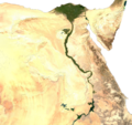
പ്രമാണം:Egypt sat.png

ഈ പ്രിവ്യൂവിന്റെ വലിപ്പം: 647 × 600 പിക്സലുകൾ. മറ്റ് റെസലൂഷനുകൾ: 259 × 240 പിക്സലുകൾ | 518 × 480 പിക്സലുകൾ | 828 × 768 പിക്സലുകൾ | 1,265 × 1,173 പിക്സലുകൾ.
പൂർണ്ണ വലിപ്പം (1,265 × 1,173 പിക്സൽ, പ്രമാണത്തിന്റെ വലിപ്പം: 2.58 എം.ബി., മൈം തരം: image/png)
പ്രമാണ നാൾവഴി
ഏതെങ്കിലും തീയതി/സമയ കണ്ണിയിൽ ഞെക്കിയാൽ പ്രസ്തുതസമയത്ത് ഈ പ്രമാണം എങ്ങനെയായിരുന്നു എന്നു കാണാം.
| തീയതി/സമയം | ലഘുചിത്രം | അളവുകൾ | ഉപയോക്താവ് | അഭിപ്രായം | |
|---|---|---|---|---|---|
| നിലവിലുള്ളത് | 14:39, 16 ജൂലൈ 2023 |  | 1,265 × 1,173 (2.58 എം.ബി.) | Mododge16 | Removed Israel/Palestine to isolate Egypt |
| 00:20, 26 ജനുവരി 2020 |  | 1,265 × 1,196 (2.65 എം.ബി.) | User-duck | Cropped white border using CropTool with precise mode. | |
| 07:58, 27 ഒക്ടോബർ 2016 |  | 1,382 × 1,241 (2.7 എം.ബി.) | Milei.vencel | Reverted to version as of 22:18, 22 November 2013 (UTC) | |
| 02:42, 16 ഓഗസ്റ്റ് 2014 |  | 1,334 × 1,192 (2.44 എം.ബി.) | Uishaki | clean up | |
| 22:18, 22 നവംബർ 2013 |  | 1,382 × 1,241 (2.7 എം.ബി.) | Amrtarek | (Halaib Triangle) | |
| 01:01, 14 ജൂലൈ 2006 |  | 1,334 × 1,192 (2.44 എം.ബി.) | Unquietwiki | ECW to TIFF to PNG (compression level 9). {{PD-MapLibrary}} |
പ്രമാണത്തിന്റെ ഉപയോഗം
താഴെ കാണുന്ന താളിൽ ഈ ചിത്രം ഉപയോഗിക്കുന്നു:
പ്രമാണത്തിന്റെ ആഗോള ഉപയോഗം
താഴെ കൊടുത്തിരിക്കുന്ന മറ്റ് വിക്കികൾ ഈ പ്രമാണം ഉപയോഗിക്കുന്നു:
- af.wikipedia.org സംരംഭത്തിലെ ഉപയോഗം
- af.wiktionary.org സംരംഭത്തിലെ ഉപയോഗം
- an.wikipedia.org സംരംഭത്തിലെ ഉപയോഗം
- ar.wikipedia.org സംരംഭത്തിലെ ഉപയോഗം
- arz.wikipedia.org സംരംഭത്തിലെ ഉപയോഗം
- ba.wikipedia.org സംരംഭത്തിലെ ഉപയോഗം
- be-tarask.wikipedia.org സംരംഭത്തിലെ ഉപയോഗം
- be.wikipedia.org സംരംഭത്തിലെ ഉപയോഗം
- bg.wikipedia.org സംരംഭത്തിലെ ഉപയോഗം
- cs.wikipedia.org സംരംഭത്തിലെ ഉപയോഗം
- de.wikipedia.org സംരംഭത്തിലെ ഉപയോഗം
- en.wikipedia.org സംരംഭത്തിലെ ഉപയോഗം
- en.wikibooks.org സംരംഭത്തിലെ ഉപയോഗം
- es.wikipedia.org സംരംഭത്തിലെ ഉപയോഗം
- fa.wikipedia.org സംരംഭത്തിലെ ഉപയോഗം
- fr.wiktionary.org സംരംഭത്തിലെ ഉപയോഗം
- hsb.wikipedia.org സംരംഭത്തിലെ ഉപയോഗം
- hu.wikipedia.org സംരംഭത്തിലെ ഉപയോഗം
- hy.wikipedia.org സംരംഭത്തിലെ ഉപയോഗം
- incubator.wikimedia.org സംരംഭത്തിലെ ഉപയോഗം
- it.wikipedia.org സംരംഭത്തിലെ ഉപയോഗം
- ko.wikipedia.org സംരംഭത്തിലെ ഉപയോഗം
- lfn.wikipedia.org സംരംഭത്തിലെ ഉപയോഗം
- lt.wikipedia.org സംരംഭത്തിലെ ഉപയോഗം
- nl.wikipedia.org സംരംഭത്തിലെ ഉപയോഗം
- pt.wikipedia.org സംരംഭത്തിലെ ഉപയോഗം
- pt.wikibooks.org സംരംഭത്തിലെ ഉപയോഗം
- ro.wikipedia.org സംരംഭത്തിലെ ഉപയോഗം
- si.wikipedia.org സംരംഭത്തിലെ ഉപയോഗം
- sl.wikipedia.org സംരംഭത്തിലെ ഉപയോഗം
- ta.wikipedia.org സംരംഭത്തിലെ ഉപയോഗം
- te.wikipedia.org സംരംഭത്തിലെ ഉപയോഗം
- tr.wikipedia.org സംരംഭത്തിലെ ഉപയോഗം
- tum.wikipedia.org സംരംഭത്തിലെ ഉപയോഗം
- uk.wikipedia.org സംരംഭത്തിലെ ഉപയോഗം
ഈ പ്രമാണത്തിന്റെ കൂടുതൽ ആഗോള ഉപയോഗം കാണുക.

