
പ്രമാണം:Breakwater break1 new(USGS).jpg

പൂർണ്ണ വലിപ്പം (1,493 × 984 പിക്സൽ, പ്രമാണത്തിന്റെ വലിപ്പം: 812 കെ.ബി., മൈം തരം: image/jpeg)
| ഈ പ്രമാണം വിക്കിമീഡിയ കോമൺസിൽ നിന്നുള്ളതാണ്. പ്രമാണത്തെക്കുറിച്ചുള്ള വിവരണം താഴെ കൊടുത്തിരിക്കുന്നു.
|
.jpg?uselang=ml)
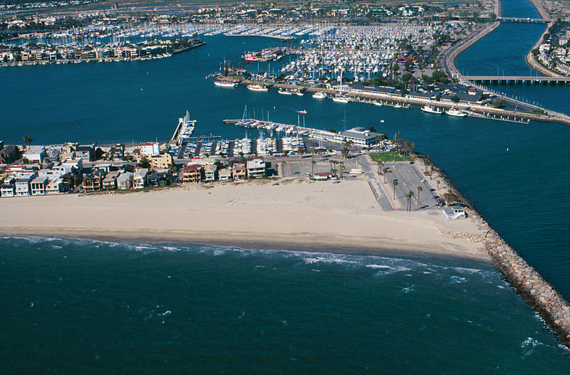
Breakwater.
Breakwaters create safe harbors but can also trap sediment moving along the coast. Long Beach Harbor, April, 1998
From: USGS
A more accurate description: The sand buildup shown is on the southeast end of the Long Beach Peninsula, with the jetty blocking the southward movement of sand being the west side of the entrance to Alamitos Bay. In the background, to the right of the center, is the Alamitos Bay Landing commercial area of the Long Beach Marina. To the far right in the back is the w:San Gabriel River. In the back top left is the sotheast end of w:Naples, a residential island in Alamitos Bay. The ocean shown in the foreground is the very southeast end of the Long Beach Outer Harbor.
ഈ സൃഷ്ടി അമേരിക്കൻ ഐക്യനാടുകളിൽ പൊതുസഞ്ചയത്തിൽ ഉള്ളതാണ്, യു.എസ്. കോഡിലെ തലക്കെട്ട് 17, ആദ്ധ്യായം 1, ഭാഗം 105 പ്രകാരം അമേരിക്കൻ ഐക്യനാടുകളിലെ ഫെഡറൽ ഭരണകൂടത്തിന്റെ സൃഷ്ടി ആയതാണ് കാരണം. പകർപ്പവകാശം കാണുക.
ശ്രദ്ധിക്കുക: ഫെഡറൽ ഭരണകൂടത്തിന്റെ സൃഷ്ടികൾക്കു മാത്രമേ ഇതു ബാധകമായിരിക്കുകയുള്ളൂ, അമേരിക്കയിലെ സംസ്ഥാനങ്ങൾ, ടെറിട്ടറി, കോമൺവെൽത്ത്, കൗണ്ടി, മുനിസിപ്പാലിറ്റി, തുടങ്ങിയ ഉപവിഭജനങ്ങളുടെ സൃഷ്ടികൾക്ക് ഇത് ബാധകമായിരിക്കില്ല. അമേരിക്കൻ ഐക്യനാടുകളിലെ തപാൽ സേവനത്തിനായി 1978-നു ശേഷം പുറത്തിറക്കിയ തപാൽ സ്റ്റാമ്പ് രൂപകല്പനകൾക്കും ഈ ഫലകം ബാധകമാക്കരുത്. (206.02(b) കോംപെൻഡിയം II: പകർപ്പവകാശ മര്യാദകൾ കാണുക). അമേരിക്കൻ ഐക്യനാടുകളിലെ ചില നാണയങ്ങൾക്കും ഇതു ബാധകമല്ല, അമേരിക്കൻ ഐക്യനാടുകളിലെ കമ്മട്ടം, ഉപയോഗനിബന്ധനകൾ. കാണുക
|
 | |
| ഈ പ്രമാണം, പകർപ്പവകാശ നിയമത്തിന്റെ അറിയപ്പെടുന്ന എല്ലാ പരിമിതപ്പെടുത്തലുകളിൽ നിന്നും, ബന്ധപ്പെട്ടതും സമീപസ്ഥവുമായ എല്ലാ അവകാശങ്ങളുമടക്കം, സ്വതന്ത്രമാണെന്ന് കണ്ടെത്തിയിരിക്കുന്നു. | ||
പ്രമാണ നാൾവഴി
ഏതെങ്കിലും തീയതി/സമയ കണ്ണിയിൽ ഞെക്കിയാൽ പ്രസ്തുതസമയത്ത് ഈ പ്രമാണം എങ്ങനെയായിരുന്നു എന്നു കാണാം.
| തീയതി/സമയം | ലഘുചിത്രം | അളവുകൾ | ഉപയോക്താവ് | അഭിപ്രായം | |
|---|---|---|---|---|---|
| നിലവിലുള്ളത് | 09:31, 10 ജൂൺ 2010 | | 1,493 × 984 (812 കെ.ബി.) | Quibik | cropped away 3 px from right edge and cloned the bottom edge a bit to remove black background |
| 09:28, 10 ജൂൺ 2010 |  | 1,496 × 984 (814 കെ.ബി.) | Quibik | removed the timestamp | |
| 18:05, 11 ഡിസംബർ 2009 |  | 1,496 × 984 (841 കെ.ബി.) | Foobaz | Larger version from http://coastal.er.usgs.gov/cgi-bin/response.pl?site=sc&loc=25 . | |
| 09:02, 21 ഏപ്രിൽ 2005 |  | 295 × 193 (9 കെ.ബി.) | Feydey | Breakwater. Breakwaters create safe harbors but can also trap sediment moving along the coast. Long Beach Harbor, April, 1998 From: [http://walrus.wr.usgs.gov/cabrillo/playa/breakwater.html USGS] {{PD-USGov}} |
പ്രമാണത്തിന്റെ ഉപയോഗം
താഴെ കാണുന്ന താളിൽ ഈ ചിത്രം ഉപയോഗിക്കുന്നു:
പ്രമാണത്തിന്റെ ആഗോള ഉപയോഗം
താഴെ കൊടുത്തിരിക്കുന്ന മറ്റ് വിക്കികൾ ഈ പ്രമാണം ഉപയോഗിക്കുന്നു:
- az.wikipedia.org സംരംഭത്തിലെ ഉപയോഗം
- da.wikipedia.org സംരംഭത്തിലെ ഉപയോഗം
- el.wikipedia.org സംരംഭത്തിലെ ഉപയോഗം
- en.wikipedia.org സംരംഭത്തിലെ ഉപയോഗം
- fi.wikipedia.org സംരംഭത്തിലെ ഉപയോഗം
- he.wikipedia.org സംരംഭത്തിലെ ഉപയോഗം
- id.wikipedia.org സംരംഭത്തിലെ ഉപയോഗം
- kn.wikipedia.org സംരംഭത്തിലെ ഉപയോഗം
- sco.wikipedia.org സംരംഭത്തിലെ ഉപയോഗം
- simple.wikipedia.org സംരംഭത്തിലെ ഉപയോഗം
- vi.wikipedia.org സംരംഭത്തിലെ ഉപയോഗം
.jpg)