
പ്രമാണം:2010 Chile earthquake epicenter.png
കൂടുതൽ വ്യക്തതയുള്ള ചിത്രം ലഭ്യമല്ല.
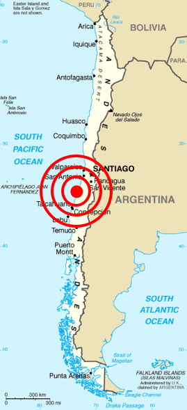
2010_Chile_earthquake_epicenter.png (269 × 589 പിക്സൽ, പ്രമാണത്തിന്റെ വലിപ്പം: 112 കെ.ബി., മൈം തരം: image/png)
| ഈ പ്രമാണം വിക്കിമീഡിയ കോമൺസിൽ നിന്നുള്ളതാണ്. പ്രമാണത്തെക്കുറിച്ചുള്ള വിവരണം താഴെ കൊടുത്തിരിക്കുന്നു.
|
| വിവരണം |
Deutsch: Karte von Chile aus dem CIA World Factbook mit dem Epizentrum des Erdbebens 2010 Chile
Español: Mapa de Chile de la CIA World Factbook, con el epicentro del terremoto de Chile 2010
Français : Carte du Chili de la CIA World Factbook avec l'épicentre du tremblement de terre du Chili 2010
Português: Mapa do Chile da CIA World Factbook, com o epicentro do terremoto do Chile em 2010 |
| തീയതി | (original); 2010-02-27 (This image) |
| സ്രോതസ്സ് | Originally from Central Intelligence Agency's World Factbook. Location of epicenter from BBC |
| സ്രഷ്ടാവ് | Central Intelligence Agency's World Factbook |
| അനുമതി (ഈ പ്രമാണത്തിന്റെ പുനരുപയോഗം) |
PD-USGOV-CIA-WF. |
അനുമതി
ഈ ചിത്രം, അമേരിക്കൻ ഐക്യനാടുകളിലെ സെൻട്രൽ ഇന്റലിജൻസ് ഏജൻസിയുടെ വേൾഡ് ഫാക്റ്റ്ബുക്കിൽ നിന്നുള്ള വിവരങ്ങൾ ഉൾക്കൊള്ളുന്നതിനാൽ പൊതുസഞ്ചയത്തിൽ വരുന്നു.
|
 |
| Annotations | This image is annotated: View the annotations at Commons |
പ്രമാണ നാൾവഴി
ഏതെങ്കിലും തീയതി/സമയ കണ്ണിയിൽ ഞെക്കിയാൽ പ്രസ്തുതസമയത്ത് ഈ പ്രമാണം എങ്ങനെയായിരുന്നു എന്നു കാണാം.
| തീയതി/സമയം | ലഘുചിത്രം | അളവുകൾ | ഉപയോക്താവ് | അഭിപ്രായം | |
|---|---|---|---|---|---|
| നിലവിലുള്ളത് | 13:45, 27 ഫെബ്രുവരി 2010 | | 269 × 589 (112 കെ.ബി.) | Cargoking | {{Information |Description=Map of en:Chile from [http://www.lib.utexas.edu/maps/cia02/chile_sm02.gif CIA World Factbook] with the epicenter of 2010 Chile earthquake marked. |Source=Originally from Central Intelligence Agen |
പ്രമാണത്തിന്റെ ഉപയോഗം
താഴെ കാണുന്ന താളിൽ ഈ ചിത്രം ഉപയോഗിക്കുന്നു:
പ്രമാണത്തിന്റെ ആഗോള ഉപയോഗം
താഴെ കൊടുത്തിരിക്കുന്ന മറ്റ് വിക്കികൾ ഈ പ്രമാണം ഉപയോഗിക്കുന്നു:
- be.wikipedia.org സംരംഭത്തിലെ ഉപയോഗം
- bg.wikipedia.org സംരംഭത്തിലെ ഉപയോഗം
- ckb.wikipedia.org സംരംഭത്തിലെ ഉപയോഗം
- cy.wikipedia.org സംരംഭത്തിലെ ഉപയോഗം
- da.wikipedia.org സംരംഭത്തിലെ ഉപയോഗം
- en.wikipedia.org സംരംഭത്തിലെ ഉപയോഗം
- en.wikinews.org സംരംഭത്തിലെ ഉപയോഗം
- eo.wikipedia.org സംരംഭത്തിലെ ഉപയോഗം
- es.wikinews.org സംരംഭത്തിലെ ഉപയോഗം
- et.wikipedia.org സംരംഭത്തിലെ ഉപയോഗം
- fa.wikipedia.org സംരംഭത്തിലെ ഉപയോഗം
- fi.wikipedia.org സംരംഭത്തിലെ ഉപയോഗം
- fr.wikinews.org സംരംഭത്തിലെ ഉപയോഗം
- ja.wikipedia.org സംരംഭത്തിലെ ഉപയോഗം
- ka.wikipedia.org സംരംഭത്തിലെ ഉപയോഗം
- lt.wikipedia.org സംരംഭത്തിലെ ഉപയോഗം
- ms.wikipedia.org സംരംഭത്തിലെ ഉപയോഗം
- no.wikinews.org സംരംഭത്തിലെ ഉപയോഗം
- pt.wikinews.org സംരംഭത്തിലെ ഉപയോഗം
- ro.wikipedia.org സംരംഭത്തിലെ ഉപയോഗം
- ro.wikinews.org സംരംഭത്തിലെ ഉപയോഗം
- ru.wikipedia.org സംരംഭത്തിലെ ഉപയോഗം
- ru.wikinews.org സംരംഭത്തിലെ ഉപയോഗം
- sh.wikipedia.org സംരംഭത്തിലെ ഉപയോഗം
- simple.wikipedia.org സംരംഭത്തിലെ ഉപയോഗം
- sq.wikipedia.org സംരംഭത്തിലെ ഉപയോഗം
- sr.wikipedia.org സംരംഭത്തിലെ ഉപയോഗം
- sv.wikipedia.org സംരംഭത്തിലെ ഉപയോഗം
- ta.wikinews.org സംരംഭത്തിലെ ഉപയോഗം
- th.wikipedia.org സംരംഭത്തിലെ ഉപയോഗം
- tr.wikipedia.org സംരംഭത്തിലെ ഉപയോഗം
- uk.wikinews.org സംരംഭത്തിലെ ഉപയോഗം
- vi.wikipedia.org സംരംഭത്തിലെ ഉപയോഗം
- www.wikidata.org സംരംഭത്തിലെ ഉപയോഗം
- zh.wikipedia.org സംരംഭത്തിലെ ഉപയോഗം